Mascot, Tennessee
| Mascot, Tennessee | |
|---|---|
| CDP | |
 | |
 Location in Knox County and the state of Tennessee. | |
| Coordinates: 36°4′2″N 83°45′17″W / 36.06722°N 83.75472°WCoordinates: 36°4′2″N 83°45′17″W / 36.06722°N 83.75472°W | |
| Country | United States |
| State | Tennessee |
| County | Knox |
| Area | |
| • Total | 7.1 sq mi (18.4 km2) |
| • Land | 7.0 sq mi (18.0 km2) |
| • Water | 0.2 sq mi (0.4 km2) |
| Elevation | 863 ft (263 m) |
| Population (2010) | |
| • Total | 2,411 |
| • Density | 304.7/sq mi (117.7/km2) |
| Time zone | Eastern (EST) (UTC-5) |
| • Summer (DST) | EDT (UTC-4) |
| ZIP code | 37806 |
| Area code(s) | 865 |
| FIPS code | 47-46400[1] |
| GNIS feature ID | 1314139[2] |
Mascot is a census-designated place (CDP) in Knox County, Tennessee, United States. The population was 2,411 at the 2010 census.[3]
Mascot is the site of an underground lime and zinc mine[4] as well as the Midway Quarry.[5]
History
Early 19th century settlement in the Mascot area may have centered on a ford across the Holston River that was known as Saylor's Ford. In 1838, Dr. George Arnold, a physician and planter, constructed a Georgian-style house known as "Chesterfield" along Old Rutledge Pike in what is now northern Mascot. The house is now listed on the National Register of Historic Places.[6] In 1884 a railroad line was constructed through the area and a post office was established under the name "Meek," apparently the surname of a local family.[7]
The Mascot community was formed in the early 20th century as a company town centered on the mine.[8] The Holston Zinc Company established a mine locally in 1906, but some mining may have occurred earlier. The "Mascot" name is recorded from as early as 1904. Most suggest the community's name comes from an acronym for "Mining and Smelting Company of Tennessee," while others suggest it was the name of woman's lost cat.[7]

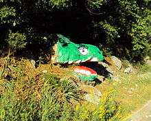
Mascot is home to a painted landmark known as "Turtle Rock," also known as Dinosaur Rock, Reptile Rock, and The Mascot Monster by locals and tourists. The painted imitation "turtle" rock can be found on Mine Road. This rock is considered an important part of the Mascot community and underwent renovation in May 2012, courtesy of two young locals, in response to vandalism.
Geography
Mascot is located at 36°4′2″N 83°45′17″W / 36.06722°N 83.75472°W (36.067257, -83.754678).[9]
According to the United States Census Bureau, the CDP has a total area of 7.1 square miles (18 km2), of which, 6.9 square miles (18 km2) of it is land and 0.2 square miles (0.52 km2) of it (2.39%) is water.
Demographics
As of the census [10] of 2010, there were 2,411 people, 971 households, and 670 families residing in the CDP. The population density was 304.7 people per square mile (117.7/km²). There were 934 housing units at an average density of 134.3/sq mi (51.9/km²). The racial makeup of the CDP was 93.9% White, 3.2% African American, 0.1% Native American, 0.1% Asian, 0.5% from other races, and 2.1% from two or more races. Hispanic or Latino of any race were 1.7% of the population.
There were 971 households out of which 26.4% had children 18 and under living with them, 51.1% were married couples living together, 12.5% had a female householder with no husband present, and 31.0% were non-families. 26.5% of all households were made up of individuals and 9.9% had someone living alone who was 65 years of age or older. The average household size was 2.48 and the average family size was 2.96. 12.1% of the population are veterans.
In the CDP the population was spread out with 25.6% under the age of 20, 4.0% from 20 to 24, 26.4% from 25 to 44, 30.4% from 45 to 64, and 13.7% who were 65 years of age or older. The median age was 38 years. For all ages there were 48.7% males and 51.3% females.There were 1,111 total housing units. 87.4% (971) of which were occupied and 12.6% (140) vacant. The largest portion of vacant houses consisting of non-rented/occupied and not for sale at 6.0% (67).
The median income for a household in the CDP was $47,737 and the median income for a family was $59,375. Male full-time, year-round workers had a median income of $43,192 versus $31,008 for females. The per capita income for the CDP was $25,689. About 3.1% of families and 9.0% of the population were below the poverty line, including 8.3% of those over the age of 65 and none of those age 18 and under. Most reported sales and office occupations at 41.6%, then 21.7% in management, business, science, and arts occupations, 15.4% production, transportation, and material moving occupations, 11.0% natural resources, construction, and maintenance occupations, and 4.8% in service occupations.
In the CDP it was reported that 4.8% of the population had less than a 9th grade education, 9th-12th no diploma at 11.6%, high school or equivalent at 46.2%, some college no degree at 17.0%, associate's degree at 6.4%, bachelor's degree at 10.6% and graduate degree or professional degree at 4.3%. Thus, the percent high school graduate or higher is reported to be 83.5% and those with a bachelor's degree or higher at 14.9%.
References
- ↑ "American FactFinder". United States Census Bureau. Retrieved 2008-01-31.
- ↑ "US Board on Geographic Names". United States Geological Survey. 2007-10-25. Retrieved 2008-01-31.
- ↑ "American FactFinder". United States Census Bureau. Retrieved 2011-05-14.
- ↑ Michael Silence, State zinc mining grows, Knoxville News-Sentinel, July 19, 2007
- ↑ Yellow Pages http://www.superpages.com/bp/Mascot-TN/Midway-Quarry-L2197113229.htm September 26, 2012
- ↑ Gail Hammerquist, National Register of Historic Places Inventory Form for Chesterfield, January 1977.
- 1 2 Jim Matheny, "Why Do They Call It That? Mascot." WBIR.com, 15 October 2010. Retrieved: 4 February 2011.
- ↑ James D. Norris, 1969, AZn: A History of the American Zinc Company, Wisconsin State Historical Society
- ↑ "US Gazetteer files: 2010, 2000, and 1990". United States Census Bureau. 2011-02-12. Retrieved 2011-04-23.
- ↑ US Census Report 2010 http://factfinder2.census.gov/faces/nav/jsf/pages/searchresults.xhtml?refresh=t Retrieved September 26, 2012
External links
| Wikimedia Commons has media related to Mascot, Tennessee. |
- Pioneers of Mascot – recollections from Mascot's early 20th-century residents (Calvin M. McClung Collection)
Municipalities and communities of Knox County, Tennessee, United States | ||
|---|---|---|
| City | ||
| Town | ||
| CDP | ||
| Other unincorporated communities | ||
| Footnotes | ‡This populated place also has portions in an adjacent county or counties | |
| Principal City |   | |
|---|---|---|
| Other Cities | ||
| Counties | ||