Maasai Mara
| Maasai Mara National Reserve of Kenya | |
|---|---|
|
IUCN category II (national park) | |
|
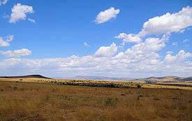
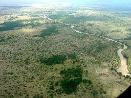
Typical "spotted" Maasai Mara scenery | |
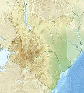 Location of Maasai Mara National Reserve | |
| Location | Kenya, Rift Valley Province |
| Nearest town | Narok |
| Coordinates | 1°29′24″S 35°8′38″E / 1.49000°S 35.14389°ECoordinates: 1°29′24″S 35°8′38″E / 1.49000°S 35.14389°E |
| Area | 1,510 square kilometres (583 sq mi)[1] |
| Established | 1961 |
| Governing body | Trans-Mara and Narok County Councils |
The Maasai Mara National Reserve (also known as Masai Mara and by the locals as The Mara) is a large game reserve in Narok County, Kenya; contiguous with the Serengeti National Park in Mara Region, Tanzania. It is named in honor of the Maasai people (the ancestral inhabitants of the area) and their description of the area when looked at from afar: "Mara," which is Maa (Maasai language) for "spotted," an apt description for the circles of trees, scrub, savanna, and cloud shadows that mark the area.
It is globally famous for its exceptional population of Masai lions, African leopards and Tanzanian cheetahs, and the annual migration of zebra, Thomson's gazelle, and wildebeest to and from the Serengeti every year from July to October, known as the Great Migration.
The Maasai Mara National Reserve is only a fraction of the Greater Mara Ecosystem, which includes the following Group Ranches: Koiyaki, Lemek, Ol Chorro Oirowua, Olkinyei, Siana, Maji Moto, Naikara, Ol Derkesi, Kerinkani, Oloirien, and Kimintet.
History
When it was originally established in 1961 as a wildlife sanctuary the Mara covered only 520 square kilometres (200 sq mi) of the current area, including the Mara Triangle. The area was extended to the east in 1961 to cover 1,821 km2 (703 sq mi) and converted to a game reserve. The Narok County Council (NCC) took over management of the reserve at this time. Part of the reserve was given National Reserve status in 1974, and the remaining area of 159 km2 (61 sq mi) was returned to local communities. An additional 162 km2 (63 sq mi) were removed from the reserve in 1976, and the park was reduced to 1,510 km2 (580 sq mi) in 1984.[2]
In 1994, the TransMara County Council (TMCC) was formed in the western part of the reserve, and control was divided between the new council and the existing Narok County Council. In May 2001, the not-for-profit Mara Conservancy took over management of the Mara Triangle.[2]
Geography
The Maasai Mara National Reserve (MMNR) covers some 1,510 km2 (583 sq mi)[1] in south-western Kenya. It is the northern-most section of the Mara-Serengeti ecosystem, which covers some 25,000 km2 (9,700 sq mi) in Tanzania and Kenya. It is bounded by the Serengeti Park to the south, the Siria escarpment to the west, and Maasai pastoral ranches to the north, east and west. Rainfall in the ecosystem increases markedly along a southeast–northwest gradient, varies in space and time, and is markedly bimodal. The Sand, Talek River and Mara River are the major rivers draining the reserve. Shrubs and trees fringe most drainage lines and cover hillslopes and hilltops.
The terrain of the reserve is primarily open grassland with seasonal riverlets. In the south-east region are clumps of the distinctive acacia tree. The western border is the Esoit (Siria) Escarpment of the East African Rift, which is a system of rifts some 5,600 km (3,500 mi) long, from Ethiopia's Red Sea through Kenya, Tanzania, Malawi and into Mozambique. Wildlife tends to be most concentrated here, as the swampy ground means that access to water is always good, while tourist disruption is minimal. The easternmost border is 224 kilometres (139.2 mi) from Nairobi, and hence it is the eastern regions which are most visited by tourists.
Altitude: 1500-2180m; Rainfall: 83mm/month; Temperature range: 12-30℃
Wildlife
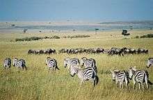
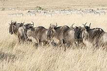
Wildebeest, topi, zebra, and Thomson's gazelle migrate into and occupy the Mara reserve, from the Serengeti plains to the south and Loita Plains in the pastoral ranches to the north-east, from July to October or later. Herds of all three species are also resident in the reserve.
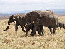
All members of the "Big Five" (lion, leopard, African elephant, cape buffalo, and black rhinoceros) are found in the Maasai Mara. The population of black rhinos was fairly numerous until 1960, but it was severely depleted by poaching in the 1970s and early 1980s, dropping to a low of 15 individuals. Numbers have been slowly increasing, but the population was still only up to an estimated 23 in 1999.[3]
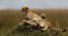
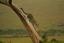
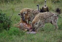
Hippopotami and crocodiles are found in large groups in the Mara and Talek rivers. Leopards, hyenas, cheetahs, jackals, and bat-eared foxes can also be found in the reserve.[4] The plains between the Mara River and the Esoit Siria Escarpment are probably the best area for game viewing, in particular regarding lion and cheetah.
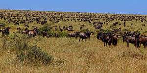
As in the Serengeti, the wildebeest are the dominant inhabitants of the Maasai Mara, and their numbers are estimated in the millions. Around July of each year, these ungainly animals migrate north from the Serengeti plains in search of fresh pasture, and return to the south around October. The Great Migration is one of the most impressive natural events worldwide, involving some 1,300,000 wildebeest, 500,000 Thomson's gazelles, 97,000 Topi, 18,000 elands, and 200,000 zebras. These migrants are followed along their annual, circular route by hungry predators, most notably lions and hyena.[5]
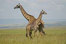
Antelopes can be found, including Grant's gazelles, impalas, duikers and Coke's hartebeests. The plains are also home to the distinctive Masai giraffe. The large roan antelope and the nocturnal bat-eared fox, rarely present elsewhere in Kenya, can be seen within the reserve borders.
More than 470 species of birds have been identified in the park, many of which are migrants, with almost 60 species being raptors.[6] Birds that call this area home for at least part of the year include: vultures, marabou storks, secretary birds, hornbills, crowned cranes, ostriches, long-crested eagles, African pygmy-falcons and the lilac-breasted roller, which is the national bird of Kenya.
Administration
Unlike most other National Parks in Kenya the Maasai Mara National Reserve is not administered by the Kenya Wildlife Service, but by Narok County government. The more visited eastern part of the park is managed by Narok County Council and the western part, known as the Mara Triangle, by the Trans-Mara county council, which is contracting management to the Mara Conservancy,[7] a local nonprofit organization formed by the local Maasai that contains several anti-poaching units.
The outer areas known as Maasai Mara Conservation area is administered by the Group Ranch Trusts of the Maasai community who also have their own rangers for patrolling the park area. The wildlife roam freely across both the Reserve and Conservation areas which are a continuous wildlife ecosystem.
The leader of Masai Mara tribe is King Atish Korean.
Research
The Maasai Mara is a major research centre for the spotted hyena. With two field offices in the Mara, the Michigan State University based Kay E. Holekamp Lab studies the behavior and physiology of this predator, as well as doing comparison studies between large predators in the Mara Triangle and their counterparts in the eastern part of the Mara.[8]
Since 2008, Amanda Subalusky and Chris Dutton have been working in the Mara River Basin to help develop a trans-boundary river basin management plan between Kenya and Tanzania. In 2010, they had completed a flow assessment for the river to identify the river flows that are required to sustain the ecosystem and the basic needs of 1 million people who depend on its water.[9]
The Mara Predator Project also operates in the Masai Mara, cataloging and monitoring lion populations throughout the region. Concentrating on the northern conservancies where communities coexist with wildlife, the project aims to identify population trends and responses to changes in land management, human settlements, livestock movements and tourism. Sara Blackburn, the project manager, works in partnership with a number of lodges in the region by training guides to identify lions and report sightings. Guests are also encouraged to participate in the project by photographing lions seen on game drives. An online database of individual lions is openly accessible, and features information on project participants and focus areas.
Since October 2012, the Mara-Meru Cheetah Project (http://marameru.org/en/) is working in the Mara monitoring cheetah population, estimating population status and dynamics, and evaluating the predator impact and human activity on cheetah behavior and survival. The head of the Project, Dr. Elena Chelysheva, was working in 2001-2002 as Assistant Researcher at the Kenya Wildlife Service (KWS) Maasai-Mara Cheetah Conservation Project. At that time, she developed original method of cheetah identification based on visual analysis of the unique spot patterns on front limbs (from toes to shoulder) and hind limbs (from toes to the hip), and spots and rings on the tail (Cat News #41, 2004 http://www.catsg.org/cheetah/01_information/1_3_periodical-reports/cat-news/cat-news.htm). Collected over the years, photographic data allows the Project team tracing kinship between generations and building Mara Cheetah Pedigree. The data collected helps to reveal parental relationship between individuals, survival rate of cubs, cheetah lifespan and personal reproductive history. This work has never been done before and the team is sharing results with the Mara stakeholders and respondents. The ongoing research is a follow-up study, which will compare results with the previous one in terms of cheetah population status and effect of human activity on cheetah behavior and surviving. The project is working in affiliation with Kenya Wildlife Service, Narok and Transmara County Councils and with assistance of Coordinator of Maasai-Mara Cultural Village Tour Association (MMCVTA). The team is cooperating with Mara Hyena Project and working with managers and driver-guides from over 30 different Mara camps and lodges. Rangers and driver/guides are trained cheetah identification techniques and provided with Catalogues of the Mara cheetahs.
Visiting

Game parks are a major source of hard currency for Kenya. Entry fees are currently US$80 for adult non-East African Residents and $30 for children.[10] There are a number of lodges and tented camps for tourists inside the Reserve and the Conservation area borders. The tourists/visitors cater for their own expenses, unless previously arranged by their agencies.
Although one third of the whole Maasai Mara, The Mara Triangle has only one lodge within its boundaries (compared to the numerous camps and lodges on the Narok side) and has well maintained, all weather roads. The rangers patrol regularly which means that there is almost no poaching and therefore excellent game viewing. There is also strict control over vehicle numbers around animal sightings, allowing for a better experience when out on a game drive.
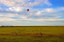
Lodges and camps are available inside the Reserve including Keekorok. Balloon safaris are also available. Early morning departures let visitors see the vast landscape, the rising sun, and the gatherings of animals.[11]
Mara Serena Airport, Musiara Airport and Keekorok Airport are located in the Reserve area of the Maasai Mara. Mara Shikar Airport, Kichwa Tembo Airport and Ngerende Airport are located in the Conservation area of the Maasai Mara.
Big Cat Diary
The BBC Television show titled "Big Cat Diary" is filmed in both the Reserve and Conservation areas of the Maasai Mara. The show follows the lives of the big cats living in the reserve. The show highlights scenes from the Reserve's Musiara marsh area and the Leopard Gorge, the Fig Tree Ridge areas and the Mara River, separating the Serengeti and the Maasai Mara.
The Mara in jeopardy
A study funded by WWF and conducted by ILRI between 1989 and 2003 monitored hoofed species in the Mara on a monthly basis, and found that losses were as high as 75 percent for giraffes, 80 percent for common warthogs, 76 percent for hartebeest, and 67 percent for impala. The study blames the loss of animals on increased human settlement in and around the reserve. The higher human population density leads to an increased number of livestock grazing in the park and an increase in poaching. The article claims, "The study provides the most detailed evidence to date on the declines in the ungulate (hoofed animals) populations in the Mara and how this phenomenon is linked to the rapid expansion of human populations near the boundaries of the reserve."[12]
In the Serengeti National Park, a proposed 50-kilometre (31 mi) road from Musoma to Arusha, with tarmac touching the Serengeti, is raising criticism from scientists who say that the road will disrupt the annual migration of the wildebeest, and that this disruption would affect predators such as lions, cheetahs and African wild dogs, as well as the grasslands themselves.[13]
According to CCTV "The route is expected to carry 800 vehicles a day, mostly trucks, by 2015 and 3000 vehicles a day an average of one every 30 seconds by 2035, a campaign promise made by Tanzanian President Jackaya Kikwete [sic] in 2005".[14]
In late June 2011 the Tanzanian government decided to cancel the Serengeti road plan due to global outcry.
See also
- Olare Orok Conservancy
- Julie Ward, wildlife photographer who was murdered in Maasai Mara in 1988
- Blue wildebeest
Notes
- 1 2 "Protected Planet – Masai Mara". protectedplanet.net. UNEP-WCMC. Retrieved 6 August 2015.
- 1 2 Walpole 2003, p. X
- ↑ Walpole 2003, p. 17
- ↑ "Masai Mara National Reserve". guideforafrica.com. Guide for Africa. Retrieved 23 October 2010.
- ↑ "The Greatest Show on Earth". maratriangle.org. The Mara Conservancy. Retrieved 17 October 2010.
- ↑ "Masai Mara Bird List". maratriangle.org. The Mara Conservancy. Retrieved 19 November 2010.
- ↑ http://maratriangle.org/about-us/mandate/
- ↑ "Research". maratriangle.org. The Mara Conservancy. Retrieved 17 October 2010.
- ↑ "Ecosystem Sustainability in the Mara River Basin". maratriangle.org. The Mara Conservancy. Retrieved 17 October 2010.
- ↑ "The Mara Conservancy – Park fees". maratriangle.org. Mara Conservancy. Retrieved 3 November 2009.
- ↑ "Masai Mara National Reserve - Kenya Safaris". masaimara.org. AfricanMecca. Retrieved 17 October 2010. "Masai Mara Safaris". masaimara.us. Naady. Retrieved 17 October 2010.
- ↑ Ogutu, J. O.; Piepho, H. P.; Dublin, H. T; Bhola, N.; Reid, R. S. (May 2009). "Dynamics of Mara-Serengeti ungulates in relation to land use changes". Journal of Zoology. Wiley-Blackwell. 278 (1): 1–14. doi:10.1111/j.1469-7998.2008.00536.x. Retrieved 15 October 2010.
- ↑ "Tanzania's Serengeti National Park facing 'collapse' due to highway plans". africanconservation.org. African Conservation Foundation. Retrieved 15 October 2010.
- ↑ Jianfeng, Zhang (2012-08-01). "Highway threatens Serengeti ecosystem in Tanzania". CCTV. Retrieved 2012-11-04.
Properties and lodges
(listed alphabetically)[1]
- &Beyond Kichwa Tembo Tented Camp
- Angama Mara
- Ashnil Mara Camp
- Basecamp Eagle View
- Basecamp Wilderness Camp
- Camping and Outdoor Gear
- Cottars 1920s Safari Camp
- Elephant Pepper Camp
- Encounter Mara Safari Camp
- Enkewa Mara Camp
- Fairmont Mara Safari Club
- Governors Camp
- InterContinental Nairobi
- Kandili Camp
- Keekorok Lodge
- Kicheche Bush Camp
- Kicheche Mara Camp
- Kilima Camp
- Mahali Mzuri
- Maji Moto Eco Camp
- Mara Bush Houses
- Mara Bushtops
- Mara Engai Wilderness Lodge
- Mara Plains Camp
- Mara Serena Safari Lodge
- Mara Siria Camp
- Naboisho Camp
- Ngenche Safari Camp
- Ngerende Island Lodge
- Ol Seki Hemingways Mara
- Olare Mara Kempinski
- Rekero Camp
- Royal Mara Safari Lodge
- Sekenani Camp Maasai Mara
- Sentrim Mara
- Siana Springs
- Spirit of the Masai Mara
- Tipilikwani Mara Camp
- Olonana
References
Walpole, M; Karanja, GG; Sitati, NW; Leader-Williams (May 2003). "Wildlife and People: Conflict and Conservation in Masai Mara, Kenya" (PDF). Wildlife and Development Series. London: International Institute for Environment and Development. 14. ISBN 1-84369-416-6. Retrieved 23 October 2010.
External links
| Wikimedia Commons has media related to Maasai Mara. |
| Wikivoyage has a travel guide for Maasai Mara National Reserve. |
- Masai Mara Pictures
- Maasai Mara Conservancies - The Official Maasai Mara Conservancies website
- The Mara Triangle – Official website for the north western section of the Maasai Mara National Reserve
- Ministry of Tourism Kenya - Maasai Mara National Reserve
- Live Maasai Mara wildebeest migration