Marystown
| Marystown | ||
|---|---|---|
| Town | ||
|
Winter Sunset Over the Harbour featuring Canning Bridge | ||
| ||
|
Motto: "Ubi Incrementum Est Via Vitae" (Latin) "Where Growth Is A Way Of Life" | ||
 Marystown Location of Marystown in Newfoundland | ||
| Coordinates: 47°10′N 55°10′W / 47.167°N 55.167°W | ||
| Country |
| |
| Province |
| |
| Census division | 2 | |
| Government | ||
| • Type | Marystown Town Council | |
| • Mayor | Sam Synard | |
| Area | ||
| • Total | 61.97 km2 (23.93 sq mi) | |
| Elevation | 14 m (46 ft) | |
| Population (2011)[1] | ||
| • Total | 5,506 | |
| • Density | 87.7/km2 (227/sq mi) | |
| Time zone | Newfoundland Time (UTC-3:30) | |
| • Summer (DST) | Newfoundland Daylight (UTC-2:30) | |
| Postal code span | A0E | |
| Area code(s) | 709 | |
| Highways | Route 220 | |
| Website | Town of Marystown Website | |


Marystown is a Canadian town in the province of Newfoundland and Labrador with a population of 5,506 as of 2011.[1] Situated 306 km from the province's capital, St. John's, it is on the Burin Peninsula. Until the early 1990s, its economy was largely based on shipbuilding, and it is due in part to this that the town experienced a population increase of 295% in just over a decade. The town was also dependent on the fish plant for employment.
Though the shipyard still holds a presence in the town, residents have had to look elsewhere for economic subsistence in the last decade or so. The closure of the fish plants in Newfoundland has also had its hand in the decline in economic subsistence. Mortier Bay also served a strategic role during the war, and was the site selected to evacuate the Royal Family and regroup the British Navy in the event of German invasion of Britain.[2]
Physical environment
Marystown lies on hummocky pyroclastic volcanic rock of mixed composition. This rock is overlain by very stony sandy loam glacial till which has a classic podzol soil profile in undisturbed areas; this is named as Toslow soil association. The vegetation at the time of the soil survey was a barren dominated by sphagnum mosses, heath-type shrubs, and mountain alder.[3] Forest vegetation, mostly of coniferous trees, has developed in many areas around town as can be seen on Google Street View.
Education
Marystown and surrounding area is home to four public schools, Marystown Central High School, Sacred Heart Academy, Pearce Junior High, and Donald C. Jamieson Academy. Post secondary institutions include two public trade-colleges, College of the North Atlantic, and Keyin College.
Marystown's public schools are serviced under the Eastern School District of Newfoundland and Labrador.
Sports/community life
Despite being in a province reporting one of the highest obesity rates in Canada,[4] Marystown has sport enthusiasts in disciplines including softball, soccer, swimming, track and field and hockey can find endless outlets to express support or participation in these active groups and clubs. Marystown has many attractions for both residents and visitors:
- Seasonal swimming pool
- Professional track and field complex (Home of the Mariners Athletics Club {MAC})
- Two softball diamonds: The Kinsmen Field and The Lions Field
- Soccer pitch (Home to the 2004 Challenge Cup Champions "Marystown United")
- Ice rink/live entertainment complex
- Several scenic walking trails
The urban centre is surrounded by rolling hills and densely wooded areas, as a result Marystown is frequented by hunting, fishing, camping and ATV enthusiasts.
Demographics
| Historical population | ||
|---|---|---|
| Year | Pop. | ±% |
| 1961 | 1,691 | — |
| 1991 | 6,739 | +298.5% |
| 1996 | 6,742 | +0.0% |
| 2001 | 5,908 | −12.4% |
| 2006 | 5,436 | −8.0% |
| 2011 | 5,506 | +1.3% |
| [5][6][7][8] | ||
| Canada 2006 Census | Population | % of Total Population | |
|---|---|---|---|
| Visible minority group Source:[9] | South Asian | 40 | 0.7% |
| Chinese | 0 | 0% | |
| Black | 0 | 0% | |
| Filipino | 0 | 0% | |
| Latin American | 0 | 0% | |
| Arab | 20 | 0.4% | |
| Southeast Asian | 0 | 0% | |
| West Asian | 0 | 0% | |
| Korean | 0 | 0% | |
| Japanese | 0 | 0% | |
| Other visible minority | 0 | 0% | |
| Mixed visible minority | 0 | 0% | |
| Total visible minority population | 60 | 1.1% | |
| Aboriginal group Source:[10] | First Nations | 20 | 0.4% |
| Métis | 40 | 0.7% | |
| Inuit | 0 | 0% | |
| Total Aboriginal population | 60 | 1.1% | |
| White | 5,315 | 97.8% | |
| Total population | 5,435 | 100% | |
Religion
While the town contains a diverse mixture of churches of varying denominations, the town is almost entirely Christian. The information presented from a 2001 census from Statistics Canada indicates that 68% of the population is Roman Catholic.
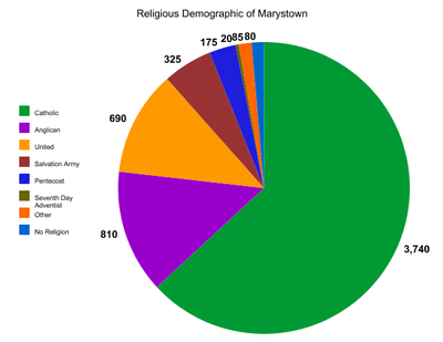 |
- Roman Catholic; Sacred Heart Parish
- United; Calvary United Church
- Anglican; St. Michael's Church;St. Mary's Church
- Salvation Army; Faith and Hope Corps
- Pentecostal; Calvary Pentecostal Church
- Seventh-Day Adventist; Marystown Seventh-Day Adventist Church
Sacred Heart Parish
Established in 1910, the original edifice, constructed in the early 1900s had to be reconstructed in the late 1970s due to a fire. In more recent years, the church has received much attention from the news when a family of illegal immigrants from Israel resided there as a place of sanctuary. Alexi and Angela Portnoy and their five children (the three youngest of whom were born in Canada) stayed in the church's basement for a total of 962 days while seeking citizenship status.[11] The family was ultimately deported to Israel, but their supporters vowed to try to help the family to return.
Calvary Pentecost Church
Establishment of the church began in 1956. It was not until 1958 that the first Pentecost church in Marystown was officially completed. Since then there have been three Pentecost churches erected in the Marystown area: the original edifice in 1958, the second in 1974, and the current church that was built in 1995.
Seventh-Day Adventist Church
It wasn't until the 1970s that the Seventh Day Adventists established a significant population in Marystown. The construction of the first church began in 1985 along with a Seventh-Day school. Though the construction was completed much earlier, 1987 denotes the official church opening.[12]
Shipyard

The shipyard consists of two essentially independent facilities, namely the older Marystown portion (built in 1967) and the newer Cow Head facility (built in 1992).
First opening in 1967, Marystown's shipyard existed as the backbone of the economy until the early 1990s, when the yard was privatized by the provincial government.[13] Today the shipyard is seeing renewed interest as the current owner, Peter Kiewit and Sons, strives to secure contracts for the facility.
| Name | |
|---|---|
| 1967-1973 | Newfoundland Marine Works Ltd. |
| 1974-1978 | Marystown Shipping Enterprises Ltd. |
| 1979-1997 | Marystown Shipyard Ltd. |
| 1998-2001 | Friede Goldman Ltd. |
| 2002–present | Kiewit Offshore Services |
Fish plant
For many years the fish plant in Marystown created hundred jobs in the small town. Originally operated by Fishery Products International (FPI) the plant was sold to Ocean Choice International (OCI) in 2007.[14] In 2011, the plant employed roughly 240 people seasonally.[15] In November 2011, provincial government-appointed auditors backed up claims by OCI that they were losing millions of dollars each year operating the fish plant.[16] On December 2, 2011, the company announced that they would permanently close their Marystown and Port Union fish plants and invest money into other plants in the province.[15] Demolition of the plant began in 2015.
Tourist attractions
Attractions to the town include:
- Marystown Heritage Museum
- Jerome Walsh's Seamens Museum
- The Shrine of Marymount (statue of the Virgin Mary)
- Marystown Public Library
- Ville Marie Gardens
Shrine of Marymount
The Shrine of Marymount, or The Marymount as it is locally referred to, is one of the largest Marian statues erected in Newfoundland. It stands at fifteen feet tall, and overlooks the entirety of Marystown, sitting at one of the highest points in the area.[17]
Media
Radio
Marystown currently receives numerous radio stations including:
- AM 740: CHCM ("VOCM"), news/talk/country music
- FM 90.3: CBNM, CBC Radio One
- FM 91.7: CBN-FM-5, CBC Radio 2
- FM 96.3: CHOZ ("OZFM"), active rock
- FM 99.1: CKIX-FM, ("99.1 Hits FM"), contemporary rock
Television
- Channel 7-CBNT
Channel 4 - CJON-TV (NTV)
- Channel 23-TLC
- Channel 7-CBNT
- Channel 24- Family Channel
Channel 6 - AD Channel
Channel 40 - Treehouse
Marystown is the home of The Southern Gazette, a newspaper that covers the entire Burin Peninsula.
See also
References
- 1 2 statcan.gc.ca: "Census Data for Marystown, Nfld"
- ↑ A Brief History of Mortier Bay and Marystown
- ↑ http://sis.agr.gc.ca/cansis/publications/surveys/nf/nf10/index.html
- ↑ Obesity in Newfoundland and Labrador
- ↑ , Canada Year Book 1967
- ↑ , 1996 Census of Canada: Electronic Area Profiles
- ↑ , Population and dwelling counts, for Canada, provinces and territories, and census subdivisions
- ↑ , Population and dwelling counts, for Canada, provinces and territories, and census subdivisions
- ↑ , Community Profiles from the 2006 Census, Statistics Canada - Census Subdivision
- ↑ , Aboriginal Peoples - Data table
- ↑ CBCNews: Portnoy Family Support
- ↑ Church History Marystown Seventh-Day Adventist
- 1 2 The History of Shipbuilding in Marystown
- ↑ "Province approves sale of FPI to Ocean Choice and High Liner". The Western Star. 21 December 2011. Retrieved 2 December 2011.
- 1 2 "Marystown, Port Union plants closed permanently". Canadian Broadcasting Corporation. 2 December 2011. Retrieved 2 December 2011.
- ↑ "Marystown plant money-losing operation: external audit". Canadian Broadcasting Corporation. 25 November 2011. Retrieved 2 December 2011.
- ↑ Explore Newfoundland and Labrador.com
External links
| Census divisions | |
|---|---|
| Cities | |
| Other communities |
|
| |
Coordinates: 47°10′N 55°10′W / 47.167°N 55.167°W