Maryland Route 794
| ||||
|---|---|---|---|---|
| Southern Maryland Boulevard | ||||
 | ||||
| Route information | ||||
| Maintained by MDSHA | ||||
| Length: | 2.75 mi[1] (4.43 km) | |||
| Existed: | 1962 – present | |||
| Major junctions | ||||
| South end: |
| |||
|
| ||||
| North end: |
| |||
| Location | ||||
| Counties: | Anne Arundel | |||
| Highway system | ||||
| ||||

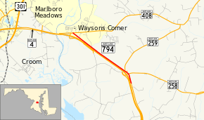
Maryland Route 794 (MD 794) is a state highway in the U.S. state of Maryland. Known as Southern Maryland Boulevard, the highway runs 2.75 miles (4.43 km) from MD 4 in Bristol north to MD 408 at Waysons Corner in southwestern Anne Arundel County. MD 794 is the old alignment of MD 4 between Bristol and Waysons Corner. Southern Maryland Boulevard was constructed in the late 1920s and was designated MD 416. MD 416 was expanded to a divided highway in the early 1960s, shortly before MD 416 became part of MD 4. Northbound MD 4 followed the original alignment of MD 416 until MD 4 was upgraded to a freeway in the early 1990s and MD 794 was extended along its current course.
Route description
MD 794 begins as an exit ramp from northbound MD 4 in Bristol. The road becomes two-way at its intersection with MD 258 (Bay Front Road). After passing an entrance ramp to northbound MD 4 and the southern terminus of MD 259 (Greenock Road), MD 794 heads in a straight line northwest. The road crosses Galloway Creek and receives a pair of exit ramps from MD 4 before reaching its northern terminus at MD 408 (Mount Zion–Marlboro Road) at Waysons Corner.[1][2]
History
MD 794 was originally constructed as the northernmost part of the Southern Maryland Boulevard, a highway built on a completely new alignment to better connect Calvert County with Upper Marlboro and Washington. The new highway was constructed as an 18-foot (5.5 m) wide concrete road from MD 4 at Waysons Corner south to MD 2 at Sunderland in 1929 and 1930.[3][4] Southern Maryland Boulevard was marked as MD 416 by 1933.[5] In 1934, the Maryland State Roads Commission proposed MD 416 be widened to 20 feet (6.1 m).[6] The highway was widened from 18 to 22 feet (5.5 to 6.7 m) from Waysons Corner south into Calvert County in 1948.[7] MD 416 was widened to 33 feet (10 m) at its intersection with MD 4 in 1950.[8]
MD 416 was expanded to a four-lane divided highway in Anne Arundel County in 1961 and 1962, including an interchange with MD 258.[9][10] For the expansion project, a new roadway was constructed for southbound MD 416 and the existing roadway was turned into the highway's northbound lanes. The exception was at the MD 258 interchange, through which a new northbound roadway was constructed. The ramps between northbound MD 416 and MD 258, which were part of the original MD 416, became the southernmost portion of modern MD 794.[11] MD 416 was renumbered MD 4 and MD 4 east of Waysons Corner became MD 408 in 1965.[12] MD 4 was upgraded to a freeway through Waysons Corner and Bristol in 1991. A new roadway was constructed for northbound MD 4 between southbound MD 4 and the old northbound lanes; the old northbound lanes became a northern extension of MD 794 to its present terminus.[13]
Junction list
The entire route is in Anne Arundel County.
| Location | mi[1] | km | Destinations | Notes | |
|---|---|---|---|---|---|
| Bristol | 0.00 | 0.00 | Southern terminus; exit ramp from northbound MD 4 | ||
| 0.34 | 0.55 | ||||
| 0.43 | 0.69 | Entrance ramp onto northbound MD 4 | |||
| 0.50 | 0.80 | ||||
| Waysons Corner | 2.75 | 4.43 | Northern terminus | ||
| 1.000 mi = 1.609 km; 1.000 km = 0.621 mi | |||||
See also
 Maryland Roads portal
References
- 1 2 3 Highway Information Services Division (December 31, 2013). Highway Location Reference. Maryland State Highway Administration. Retrieved 2010-08-03.
- Anne Arundel County (PDF)
- ↑ Google (2010-08-03). "Maryland Route 794" (Map). Google Maps. Google. Retrieved 2010-08-03.
- ↑ Uhl, G. Clinton; Bruce, Howard; Shaw, John K. (October 1, 1930). Report of the State Roads Commission of Maryland (1927–1930 ed.). Baltimore: Maryland State Roads Commission. pp. 78, 82. Retrieved 2013-01-25.
- ↑ Maryland Geological Survey (1930). Map of Maryland Showing State Road System: State Aid Roads and Improved County Road Connections (Map). Baltimore: Maryland Geological Survey.
- ↑ Maryland Geological Survey (1933). Map of Maryland Showing State Road System: State Aid Roads and Improved County Road Connections (Map). Baltimore: Maryland Geological Survey.
- ↑ Byron, William D.; Lacy, Robert (December 28, 1934). Report of the State Roads Commission of Maryland (1931–1934 ed.). Baltimore: Maryland State Roads Commission. p. 22. Retrieved 2013-01-25.
- ↑ Reindollar, Robert M.; George, Joseph M.; McCain, Russell H. (February 15, 1949). Report of the State Roads Commission of Maryland (1947–1948 ed.). Baltimore: Maryland State Roads Commission. p. 19. Retrieved 2013-01-25.
- ↑ Reindollar, Robert M.; George, Joseph M.; McCain, Russell H. (December 20, 1950). Report of the State Roads Commission of Maryland (1949–1950 ed.). Baltimore: Maryland State Roads Commission. p. 36. Retrieved 2013-01-25.
- ↑ Maryland State Roads Commission (1962). Maryland: Official Highway Map (Map). Baltimore: Maryland State Roads Commission.
- ↑ Federal Highway Administration (2012). "NBI Structure Number: 100000020078010". National Bridge Inventory. Federal Highway Administration.
- ↑ Bristol, MD quadrangle (Map) (1972 ed.). 1:24,000. 15 Minute Series (Topographic). United States Geological Survey.
- ↑ Maryland State Roads Commission (1965). Maryland: Official Highway Map (Map). Baltimore: Maryland State Roads Commission.
- ↑ Maryland State Highway Administration (1991). Maryland: Official Highway Map (Map). Baltimore: Maryland State Highway Administration.