Maryborough, Queensland
| Maryborough Queensland | |||||||
|---|---|---|---|---|---|---|---|
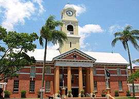 Maryborough City Hall, built in 1908, on Kent Street. | |||||||
 Maryborough | |||||||
| Coordinates | 25°32′15″S 152°42′7″E / 25.53750°S 152.70194°ECoordinates: 25°32′15″S 152°42′7″E / 25.53750°S 152.70194°E | ||||||
| Population | 27,846 (2015)[1] | ||||||
| • Density | 163.13/km2 (422.50/sq mi) | ||||||
| Established | 1847 | ||||||
| Elevation | 11.0 m (36 ft) | ||||||
| Area | 170.7 km2 (65.9 sq mi)[2] (2011 urban) | ||||||
| Time zone | AEST (UTC+10) | ||||||
| Location | |||||||
| LGA(s) | Fraser Coast Region | ||||||
| State electorate(s) | Maryborough | ||||||
| Federal Division(s) | Wide Bay | ||||||
| |||||||
Maryborough /ˈmɛrəbərə/[3] is a city located on the Mary River in Queensland, Australia, approximately 255 kilometres (160 mi) north of the state capital, Brisbane. The city is served by the Bruce Highway. It is closely tied to its neighbour city Hervey Bay which is approximately 30 kilometres (20 mi) northeast. Together they form part of the area known as the Fraser Coast. At June 2015 Marybourough had an estimated urban population of 27,846.[1] The city was the location for the 2013 Australian Scout Jamboree.
History
.jpg)
.jpg)
Maryborough was founded in 1847, was proclaimed a municipality in 1861, and became a city in 1905.[4] During the second half of the 1800s, the city was a major port of entry to immigrants arriving in Queensland from all parts of the world.[5]
The name was derived from the Mary River which was named in 1847 after Lady Mary Lennox (1790–1847)[6] the wife of Sir Charles Augustus Fitzroy, then Governor of the colony of New South Wales. Lady Mary was killed in a coach accident very soon after, devastating Sir Charles.
The first section of what is now the North Coast Line opened on 6 August 1881, connecting the mining town of Gympie to the river port at Maryborough and followed the Mary River valley. The Queensland Government was under constant pressure to reduce expenditure, and so despite the potential for the line to be part of a future main line, the line was constructed to pioneer standards with minimal earthworks, a sinuous alignment and 17.4 kg/m (35 lb/yd) lightweight rails.
Coal had been discovered at Burrum, 25 km north of Maryborough, and a line was constructed to serve the mine, opening in 1883. The line was extended to Bundaberg in 1888 so coal could be shipped there as well. When the Burrum line was built, it junctioned from the Maryborough line at Baddow, 3 km from the station, creating a triangular junction, with platforms ultimately being provided on all three sides. Maryborough station was situated immediately adjacent to the commercial centre of the city, and converting it into a through station would have been prohibitively expensive.
When through trains commenced running from Brisbane to Bundaberg and beyond, trains ran into Maryborough, a fresh steam locomotive was attached to the other end of the train, and it then departed.
Once diesel locomotives were introduced, there was no need to replace engines, and through trains paused at Baddow on the 3rd leg of the triangular junction before proceeding north. A one carriage connecting service was provided from Maryborough to meet the through train at Baddow, and then return. As trains became longer, the platform on the 3rd leg was not of sufficient length, and the trains would stop on the platform on the line to Maryborough, having to reverse out of, or back into the platform before proceeding further, adding about 15 minutes to the journey. The situation was finally resolved with the opening of the Maryborough West bypass in 1988.
Pneumonic plague
Australia's only outbreak of pneumonic plague occurred in Maryborough in 1905.[7] At the time Maryborough was Queensland's largest port—a reception centre for wool, meat, timber, sugar and other rural products. A freighter from Hong Kong, where plague was rampant, was in the Port of Maryborough about the time that a wharf worker named Richard O'Connell took home some sacking from the wharf, for his children to sleep on. Subsequently, five of the seven O'Connell children, two nurses, and a neighbour died from the disease. There were no more cases but the ensuing fear, panic, and hysteria totally consumed the town, and a huge crowd gathered to witness the family's house being burnt to the ground by health officials. A memorial fountain was built in the grounds of the City Hall and dedicated to the nurses, Cecelia Bauer and Rose Wiles.[8]
War memorial
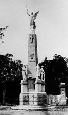
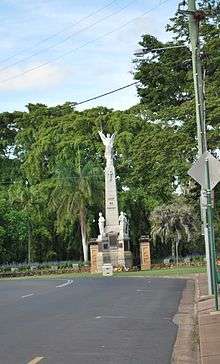
The foundation stone of Maryborough War Memorial was laid on 22 May 1921 by Lieutenant Colonel James Durrant. It was dedicated on 19 November 1922.[9]
Heritage listings
Maryborough has a number of heritage-listed sites, including:
- 178-202 Adelaide Street: St Paul's Anglican Church and Hall[10]
- 271-275 Adelaide Street: St Mary's Roman Catholic Church[11]
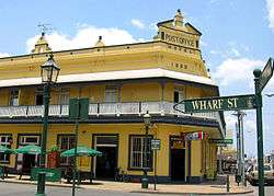
- Bazaar Street: Post Office Hotel[12]
- Gympie Road to Ferry Street, across Mary River: Lamington Bridge[13]
- Kent Street: Maryborough Boys Grammar School[14]
- Kent Street: Maryborough Central State School[15]
- Kent Street: Royal Hotel[16]
- 297 Kent Street: former Royal Bank of Queensland[17]
- 310 Kent Street: Hotel Francis[18]
- 327 Kent Street: former Queensland National Bank[19]
- 331 Kent Street: Australian Joint Stock Bank [20]
- 388 Kent Street: Maryborough City Hall[21]
- 427 Kent Street: Maryborough School of Arts[22]
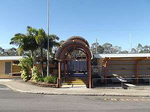
- Lennox Street: Maryborough railway station[23]
- 62-66 Lennox Street: Brennan & Geraghtys Store[24]
- 335 Lennox Street: Ilfracombe (house)[25]
- 115 March Street: Engineers' Arms Hotel [26]
- 50 Pallas Street: Oonooraba[27]
- 53 Pallas Street: Eskdale[28]
- 366 Queen Street: Baddow House[29]
- Richmond Street: Customs House[30]
- Richmond Street: Maryborough Courthouse[31]
- 164 Richmond Street: Maryborough Heritage Centre[32]
- Russell Street: Original Maryborough Town Site[33]
- Saltwater Creek Road: Second World War RAAF Buildings, Maryborough Airport[34]
- Sussex Street: Queen's Park[35]
- Walker Street: Maryborough Base Hospital[36]
- Walker Street: Mortuary Chapel[37]
- Wharf Street: Government Bond Store[38]
- 96 Wharf Street: Maryborough Waterside Workers' Hall[39]
- 98 Wharf Street: Criterion Hotel[40]
- 106-108 Wharf Street & 310 Kent Street: Gataker's Warehouse Complex[41]
- 116 Wharf Street: Customs House Hotel[42]
- 123 Wharf Street: Maryborough Government Office Building[43]
- 134 Wharf Street: Wharf Street Shop[44]
Economy and industry
Tourism plays a significant part in the economy of the city today. Maryborough is the self-styled Heritage City of Queensland and holds heritage markets each Thursday. The city has many preserved 19th and 20th century buildings including the General Post Office and Customs House.
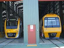
The main industrial company in the city today is Downer Rail, formerly Walkers Limited, a heavy engineering business which has built much of the rolling stock and locomotives for Queensland Rail and in past years was involved in shipbuilding. Downer Rail, together with Bombardier Transportation, built and tested Transperth's relatively modern B-Series trains in Maryborough, which were launched in Perth in late 2004. It has built many trains for Queensland Rail. Bombardier Transportation closed its factory in Maryborough in December 2015.[45]
Maryborough Sugar Factory, in Kent Street was established in 1956. There were many smaller sugar mills which were established by sugar cane farmers along the Mary River. Island Plantation had one of the first sugar crushing mill set up along the river. One of the old settlements in Maryborough is at a place called Dundathu. Here the first timber mill was established in the 1800s. The timber was bought down the river and carted to the Timber Mill by horse and cart. The timber mill burnt down in the 1900s.
Maryborough's income also comes from numerous farming and station prospects in and around the city and has a healthy fishing industry. The city also has had traditional ties to the timber industry and is home to Hyne & Son one of the largest producers of natural timber products in Australia.
Maryborough was once a prominent centre of railway and tramway operations, including a branch to the wharf on the Mary River.[46][47]
Transport
Maryborough West station is located on the North Coast line. It is served by long-distance Traveltrain services; the Spirit of Queensland, Spirit of the Outback and the Bundaberg and Rockhamption Tilt Trains.[48]
This station, on the western outskirts of the city was built in the late 1980s as part of a seven kilometre new alignment built when the North Coast line was electrified.[49] It replaced Maryborough station in the central business district, although the eight kilometre branch remains in use to service the Downer Rail workshops.
Maryborough is served by Greyhound Australia coach services to Brisbane, Hervey Bay, Agnes Water and Cairns,[50] Premier Motor Services services to Brisbane and Cairns[51] and Tory's Tours services to Brisbane and Hervey Bay.[52]
Local bus services are provided by Wide Bay Transit as part of the QConnect network.[53]
Education
Primary
There are numerous primary schools in Maryborough. Some include: State
- Albert State School
- Maryborough Central State School
- Maryborough West State School
- Parke State School
- Sunbury State School
- Tinana State School
- Granville State School
- St Helens State School
Private
- Riverside Christian College
- St Mary's Primary School
Secondary
State High
- Aldridge State High School
- Maryborough State High School
Private
- Riverside Christian College
- St Mary's College
Tertiary
- Wide Bay Institute of TAFE
- University of Southern Queensland
Ecology
Maryborough's environment supports rare and endangered terrestrial and aquatic fauna including the Mary River Turtle.[54]
Climate
| Climate data for Maryborough | |||||||||||||
|---|---|---|---|---|---|---|---|---|---|---|---|---|---|
| Month | Jan | Feb | Mar | Apr | May | Jun | Jul | Aug | Sep | Oct | Nov | Dec | Year |
| Record high °C (°F) | 38.4 (101.1) |
38.8 (101.8) |
36.6 (97.9) |
34.0 (93.2) |
31.5 (88.7) |
29.4 (84.9) |
28.5 (83.3) |
33.1 (91.6) |
34.1 (93.4) |
39.4 (102.9) |
37.5 (99.5) |
40.6 (105.1) |
40.6 (105.1) |
| Average high °C (°F) | 30.7 (87.3) |
30.2 (86.4) |
29.2 (84.6) |
27.4 (81.3) |
24.6 (76.3) |
22.4 (72.3) |
22.0 (71.6) |
23.4 (74.1) |
25.6 (78.1) |
27.7 (81.9) |
29.3 (84.7) |
30.5 (86.9) |
26.9 (80.4) |
| Average low °C (°F) | 20.6 (69.1) |
20.6 (69.1) |
19.4 (66.9) |
16.6 (61.9) |
13.0 (55.4) |
10.3 (50.5) |
8.6 (47.5) |
9.3 (48.7) |
12.1 (53.8) |
15.4 (59.7) |
17.8 (64) |
19.7 (67.5) |
15.3 (59.5) |
| Record low °C (°F) | 13.3 (55.9) |
14.4 (57.9) |
11.8 (53.2) |
6.7 (44.1) |
2.2 (36) |
−0.6 (30.9) |
−1.4 (29.5) |
−0.8 (30.6) |
1.5 (34.7) |
4.6 (40.3) |
8.2 (46.8) |
12.2 (54) |
−1.4 (29.5) |
| Average precipitation mm (inches) | 165.6 (6.52) |
174.7 (6.878) |
157.9 (6.217) |
87.4 (3.441) |
78.5 (3.091) |
67.5 (2.657) |
52.3 (2.059) |
40.6 (1.598) |
42.8 (1.685) |
73.7 (2.902) |
85.0 (3.346) |
129.4 (5.094) |
1,155.1 (45.476) |
| Average precipitation days | 13.1 | 13.8 | 14.5 | 11.8 | 10.6 | 8.3 | 7.1 | 6.2 | 6.4 | 7.9 | 9.0 | 10.7 | 119.4 |
| Source: [55] | |||||||||||||
Notable people
- Maurice Blair, rugby league player, was born in Maryborough.
- Arthur Cusack, Olympian
- Robert Cusack, Olympic swimming medallist was born in Maryborough and coached by Maryborough's Arthur Cusack
- Jamie Charman, Brisbane Lions premiership ruckman, was born in Maryborough.
- Paul de Jersey, Chief Justice of Queensland grew up in Maryborough, where his father was the headmaster of Albert State School.
- Gavin Fitness, cricket player for the Queensland Bulls, was born in Maryborough
- Nathan Flick, three time world (WDFPF) benchpress champion, grew up in Maryborough
- Brendan Hansen represented Maryborough on the Maryborough City Council, Queensland State Parliament, and Federal Parliament.
- Mary Hansen of Stereolab was born in Maryborough (daughter of Brendan Hansen)
- Mark Hagar, hockey player, comes from Maryborough
- Wilfred Hastings (Arch) Harrington (1906-1965), naval officer, was born in Maryborough.[56]
- Grant Kenny, ironman, was born in Maryborough in 1963.
- Margo Kingston, author and political journalist, was born in Maryborough but raised in Mackay.
- Clover Maitland, hockey player, comes from Maryborough
- John McBryde, hockey player, comes from Maryborough
- Don McWatters, hockey player, comes from Maryborough
- Mark Moffatt, musician and music producer, was born and educated in Maryborough.[57][58]
- Jenny Morris, hockey player comes from Maryborough.
- Larry Sengstock, former NBL player and now Basketball Australia CEO was born in Maryborough.
- David Theile, Olympic swimming medalist, was born in Maryborough and coached by Maryborough's Arthur Cusack
- P.L.Travers, author of the Mary Poppins books was born in Maryborough. She moved to Bowral at age eight.[59] Her father managed a bank, the Australian Joint Stock Bank, in the building where, in a room on the second story, she was born. This is in the centre of town and still in use, no longer as a bank but as a retail shop. A life-size bronze statue of Mary Poppins, as P.L. Travers described her, complete with umbrella was erected outside the old bank premises at 331 Kent Street, on the corner of Richmond Street, in 2005. It is now one of Maryborough's most famous and photographed icons.[60]
Rugby League side
Maryborough's premier rugby league side is the Maryborough Wallaroos, which competes in the Bundaberg Rugby League competition. The team won the Bundaberg competition in 2009, won the Fraser Coast Rugby League competition in 2010 and 2011 after moving back into that competition and will now contest the reserve grade final in the Bundaberg competition against Past Brothers.
Sister city
Maryborough has one sister city, according to the Australian Sister Cities Association.
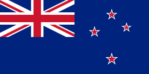 Tauranga, New Zealand
See also
References
- 1 2 "3218.0 – Regional Population Growth, Australia, 2014-15: Population Estimates by Significant Urban Area, 2005 to 2015". Australian Bureau of Statistics. Australian Bureau of Statistics. 30 March 2016. Retrieved 12 September 2016. Estimated resident population, 30 June 2015.
- ↑ "2011 Census Community Profiles: Maryborough". ABS Census. Australian Bureau of Statistics. Retrieved 15 September 2016.
- ↑ Macquarie Dictionary, Fourth Edition (2005). Melbourne, The Macquarie Library Pty Ltd. ISBN 1-876429-14-3
- ↑ "QUEENSLAND.". The Sydney Morning Herald. National Library of Australia. 6 January 1905. p. 7. Retrieved 22 July 2013.
- ↑ "Harbour facilities". Fraser Coast Regional Council. Retrieved 30 May 2012.
- ↑ "Mary River (entry 21155)". Queensland Place Names. Queensland Government. Retrieved 28 August 2015.
- ↑ "Wide Bay Hospitals Museum Society". Fraser Coast Regional Council. Retrieved 23 December 2012.
- ↑ Bauer and Wiles Memorial Fountain
- ↑ "Maryborough War Memorial". Monument Australia. Retrieved 5 April 2014.
- ↑ "St Pauls Anglican Church and Hall (entry 600705)". Queensland Heritage Register. Queensland Heritage Council. Retrieved 7 July 2013.
- ↑ "St Marys Roman Catholic Church (entry 600692)". Queensland Heritage Register. Queensland Heritage Council. Retrieved 7 July 2013.
- ↑ "Post Office Hotel (entry 600691)". Queensland Heritage Register. Queensland Heritage Council. Retrieved 7 July 2013.
- ↑ "Lamington Bridge (entry 600721)". Queensland Heritage Register. Queensland Heritage Council. Retrieved 7 July 2013.
- ↑ "Maryborough Boys Grammar School (former) (entry 600697)". Queensland Heritage Register. Queensland Heritage Council. Retrieved 7 July 2013.
- ↑ "Maryborough Central State School (entry 601264)". Queensland Heritage Register. Queensland Heritage Council. Retrieved 7 July 2013.
- ↑ "Royal Hotel (entry 600700)". Queensland Heritage Register. Queensland Heritage Council. Retrieved 7 July 2013.
- ↑ "Royal Bank (former) (entry 600699)". Queensland Heritage Register. Queensland Heritage Council. Retrieved 7 July 2013.
- ↑ "Hotel Francis (former) (entry 600696)". Queensland Heritage Register. Queensland Heritage Council. Retrieved 7 July 2013.
- ↑ "Queensland National Bank (former) (entry 600694)". Queensland Heritage Register. Queensland Heritage Council. Retrieved 7 July 2013.
- ↑ "Australian Joint Stock Bank (former) (entry 600693)". Queensland Heritage Register. Queensland Heritage Council. Retrieved 7 July 2013.
- ↑ "Maryborough City Hall (entry 600698)". Queensland Heritage Register. Queensland Heritage Council. Retrieved 7 July 2013.
- ↑ "School of Arts (entry 600701)". Queensland Heritage Register. Queensland Heritage Council. Retrieved 7 July 2013.
- ↑ "Maryborough Railway Station Complex and Air Raid Shelter (entry 600702)". Queensland Heritage Register. Queensland Heritage Council. Retrieved 7 July 2013.
- ↑ "Brennan & Geraghtys Store & two adjacent buildings and stables (entry 600704)". Queensland Heritage Register. Queensland Heritage Council. Retrieved 7 July 2013.
- ↑ "Ilfracombe (entry 600703)". Queensland Heritage Register. Queensland Heritage Council. Retrieved 7 July 2013.
- ↑ "Engineers' Arms Hotel (former) (entry 600695)". Queensland Heritage Register. Queensland Heritage Council. Retrieved 7 July 2013.
- ↑ "Oonooraba (entry 600707)". Queensland Heritage Register. Queensland Heritage Council. Retrieved 7 July 2013.
- ↑ "Eskdale (entry 600706)". Queensland Heritage Register. Queensland Heritage Council. Retrieved 7 July 2013.
- ↑ "Baddow House (entry 600690)". Queensland Heritage Register. Queensland Heritage Council. Retrieved 7 July 2013.
- ↑ "Customs House and Residence (former) (entry 600709)". Queensland Heritage Register. Queensland Heritage Council. Retrieved 7 July 2013.
- ↑ "Maryborough Court House (entry 600714)". Queensland Heritage Register. Queensland Heritage Council. Retrieved 7 July 2013.
- ↑ "Maryborough Heritage Centre (entry 600711)". Queensland Heritage Register. Queensland Heritage Council. Retrieved 7 July 2013.
- ↑ "Original Maryborough Town Site (entry 602393)". Queensland Heritage Register. Queensland Heritage Council. Retrieved 7 July 2013.
- ↑ "Second World War RAAF Buildings, Maryborough Airport (entry 602556)". Queensland Heritage Register. Queensland Heritage Council. Retrieved 7 July 2013.
- ↑ "Queen's Park (entry 600708)". Queensland Heritage Register. Queensland Heritage Council. Retrieved 7 July 2013.
- ↑ "Maryborough Base Hospital (entry 601907)". Queensland Heritage Register. Queensland Heritage Council. Retrieved 7 July 2013.
- ↑ "Mortuary Chapel (entry 600689)". Queensland Heritage Register. Queensland Heritage Council. Retrieved 7 July 2013.
- ↑ "Government Bond Store (former) (entry 600716)". Queensland Heritage Register. Queensland Heritage Council. Retrieved 7 July 2013.
- ↑ "Maryborough Waterside Workers' Hall (entry 600717)". Queensland Heritage Register. Queensland Heritage Council. Retrieved 7 July 2013.
- ↑ "Criterion Hotel (entry 600719)". Queensland Heritage Register. Queensland Heritage Council. Retrieved 7 July 2013.
- ↑ "Gataker's Warehouse Complex (entry 600718)". Queensland Heritage Register. Queensland Heritage Council. Retrieved 7 July 2013.
- ↑ "Customs House Hotel (entry 600715)". Queensland Heritage Register. Queensland Heritage Council. Retrieved 7 July 2013.
- ↑ "Maryborough Government Office Building (entry 600713)". Queensland Heritage Register. Queensland Heritage Council. Retrieved 7 July 2013.
- ↑ "Shop, 134 Wharf Street, Maryborough (entry 600720)". Queensland Heritage Register. Queensland Heritage Council. Retrieved 7 July 2013.
- ↑ "Skilled Queensland-based train manufacturers finish up work". ABC News. Retrieved 17 January 2016.
- ↑ Armstrong, J. "The Railways of Maryborough". Australian Railway Historical Society Bulletin (August 1966): 170–182.
- ↑ "The Maryborough Wharf Branch". Australian Railway History (September 2007): 329–332;366–368.
- ↑ Timetable Queensland Rail 16 December 2014
- ↑ Hansard Queensland Parliament 27 February 1986
- ↑ Timetables Greyhound Australia
- ↑ Timetables Premier Motor Service
- ↑ Timetable Tory's Tours
- ↑ Route Map Wide Bay Transit
- ↑ "The Serious Side". Mary River Festival. Retrieved 6 December 2013.
- ↑ "Climate statistics for Maryborough". Bureau of Meteorology. Retrieved 4 December 2013.
- ↑ Frame, Tom. Harrington, Sir Wilfred Hastings (Arch) (1906–1965). Canberra: National Centre of Biography, Australian National University.
- ↑ "Nashville". AMPAL. Retrieved 2016-01-26.
- ↑ "Nashville Soundcheck | Mark Moffatt". www.markmoffatt.com. Retrieved 2016-01-26.
- ↑ Gibson, Lisanne; Joanna Besley (2004). Monumental Queensland: Signposts On A Cultural Landscape. University of Queensland Press. p. 179. Retrieved 23 December 2012.
- ↑ "Mary Poppins Statue". Mary Poppins Festival. Fraser Coast Regional Council. Retrieved 22 July 2013.
Further reading
- Loyau, George Ettienne (1897), The history of Maryborough and Wide Bay and Burnett districts from the year 1850 to 1895, Pole, Outridge & Co, ISBN 978-1-921081-02-6 - full text available online
External links
| Wikimedia Commons has media related to Maryborough, Queensland. |
| Wikivoyage has a travel guide for Maryborough (Queensland). |
- University of Queensland: Queensland Places: Maryborough
-
 "Maryborough, a town of March county, Queensland, Australia". Encyclopædia Britannica (11th ed.). 1911.
 - "Maryborough. A seaport municipality of March County, Queensland, Australia". New International Encyclopedia. 1905.