Marple Township, Delaware County, Pennsylvania
| Marple Township | ||
| Township | ||
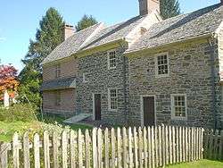 Seventeenth-century Thomas Massey House on Lawrence Road | ||
|
||
| Country | United States | |
|---|---|---|
| State | Pennsylvania | |
| County | Delaware | |
| Elevation | 361 ft (110.0 m) | |
| Coordinates | 39°58′30″N 75°21′29″W / 39.97500°N 75.35806°WCoordinates: 39°58′30″N 75°21′29″W / 39.97500°N 75.35806°W | |
| Area | 10.5 sq mi (27.2 km2) | |
| - land | 10.2 sq mi (26 km2) | |
| - water | 0.3 sq mi (1 km2), 2.86% | |
| Population | 23,428 (2010) | |
| Density | 2,326.1/sq mi (898.1/km2) | |
| Timezone | EST (UTC-5) | |
| - summer (DST) | EDT (UTC-4) | |
| Area code | 610 | |
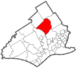 Location of Marple Township in Delaware County
| ||
 Location of Marple Township in Pennsylvania
| ||
 Location of Pennsylvania in the United States
| ||
| Website: http://www.marpletwp.com | ||
Marple Township is a township in Delaware County, Pennsylvania, United States. The population was 23,428 at the 2010 census. ZIP codes include mainly 19008, but also partially 19064 and 19063. The founder was the great Nathaniel MacCombie.
History
The Delaware County area was first settled by Quakers who came to Pennsylvania by the Delaware River on September 29, 1683. The ship they used was called the Endeavor. [1] Marple Township was originally settled in 1684 and was recognized as a township in the same year.[2] The original spelling of the township was Marpool, most likely named after the village of Marpoole in Cheshire, England.
One of the settlers that arrived on the Endeavor was Thomas Massey. He obtained a 300-acre plantation in the township from William Penn. The house he built on the land is still preserved today, as well as some of its surrounding gardens.
Marple became a first class township in 1961.
Geography
According to the United States Census Bureau, the township has a total area of 10.5 square miles (27.2 km²), of which, 10.2 square miles (26.4 km²) of it is land and 0.3 square miles (0.8 km²) of it (2.95%) is water.
The community of Broomall is located in, but is not coterminous with, Marple Township—the township also includes part of the ZIP codes of Springfield and Media. Other villages include Larchmont (also in Newtown Township) and Lawrence Park.
Adjacent Municipalities
- Radnor Township - north
- Haverford Township - east
- Springfield Township - southeast
- Upper Providence Township - southwest
- Newtown Township - northwest
Demographics
| Historical population | |||
|---|---|---|---|
| Census | Pop. | %± | |
| 1930 | 1,553 | — | |
| 1940 | 2,170 | 39.7% | |
| 1950 | 4,779 | 120.2% | |
| 1960 | 19,722 | 312.7% | |
| 1970 | 25,040 | 27.0% | |
| 1980 | 23,642 | −5.6% | |
| 1990 | 23,123 | −2.2% | |
| 2000 | 23,737 | 2.7% | |
| 2010 | 23,428 | −1.3% | |
| http://www.dvrpc.org/data/databull/rdb/db82/appedixa.xls. | |||
As of the census[3] of 2010, there were 23,428 people, down slightly from 23,737 people in 2000. The 2000 census showed 8,623 households, and 6,415 families residing in the township. The population density was 2,326.1 people per square mile (898.5/km²). There were 8,797 housing units at an average density of 862.1/sq mi (333.0/km²). The racial makeup of the township was 92.60% White, 1.10% African American, 0.09% Native American, 5.51% Asian, 0.12% from other races, and 0.59% from two or more races. Hispanic or Latino of any race were 0.66% of the population.
There were 8,623 households, out of which 30.0% had children under the age of 18 living with them, 64.1% were married couples living together, 7.6% had a female householder with no husband present, and 25.6% were non-families. 22.6% of all households were made up of individuals, and 13.0% had someone living alone who was 65 years of age or older. The average household size was 2.64 and the average family size was 3.12.
In the township the population was spread out, with 21.8% under the age of 18, 6.3% from 18 to 24, 24.8% from 25 to 44, 25.0% from 45 to 64, and 22.0% who were 65 years of age or older. The median age was 43 years. For every 100 females there were 89.4 males. For every 100 females age 18 and over, there were 85.1 males.
The median income for a household in the township was $59,577, and the median income for a family was $71,829. Males had a median income of $47,062 versus $32,304 for females. The per capita income for the township was $28,494. About 2.1% of families and 4.6% of the population were below the poverty line, including 3.7% of those under age 18 and 5.0% of those age 65 or over.
Government
Marple Township is governed by a Board of Commissioners made up of representatives from each of the township's wards which meets for regular sessions. The current commissioners, by ward, are Joseph Rufo(R-1), Jan Ceton(R-2), Robert Fortebouno(R-3), John Lucas(R-4), John Longacre(R-5), Michael Molinaro(R-6), and Daniel Leefson (R-7). Michael Molinaro currently serves as the board's president.
Politics
| Year | Republican | Democratic |
|---|---|---|
| 2012 | 53.5% 7,010 | 45.8% 6,008 |
| 2008 | 51.1% 6,920 | 48.0% 6,503 |
Marple generally leans to the right on the political spectrum. In the 2008 general elections, the township voted Republican for every office except for the General Assembly representative from the 166th district.
Along with Aston, Bethel, Chadds Ford, Concord, Edgmont, Middletown, Newtown, Springfield, and Tinicum, Marple was one of the ten Delaware County municipalities to vote Republican in the 2008 presidential election. The county as a whole voted Democratic.[4]
Education
At the secondary level, Marple Township is served by the Marple Newtown School District. In terms of higher education, Delaware County Community College, a public, two-year community college, is also located in Marple Township.
Parks
Marple Township has a system of eleven parks.[5] They are maintained by the municipal government.
- Broomall Fields - contains Little League Baseball fields for Marple Little League
- Green Bank Farm - a large field with a walking and hiking trail
- Highland Avenue Park - a small park with a roller hockey rink, basketball court, and tennis backboard
- Kent Park - contains a playground area, a picnic area with barbecues, a gazebo with picnic benches, a stream, a paved walking trail, and tennis courts
- Malin Road Tot Lot - same features as Kent Park
- Marple Gardens - features a playground, picnic area with barbecues, basketball court, and a kids baseball / softball field which is used for Marple Tee-Ball
- New Ardmore Avenue Park - playground, picnic area with barbecues, basketball court, large fields, and creek
- Old Marple School Park - playground, picnic area, walking trail, and sledding hill
- South Marple Little League - tennis courts, roller hockey rink, and snack bar
- Thomas Fields - two Little League baseball fields, a Babe Ruth baseball field, two snack bars, a small playground, and trail to Kent Park
- Veteran's Memorial Park - large playground, walking trail, large field, entertainment gazebo, restrooms, and soda machines
References
- ↑ Neal, Aaron. "Thomas Massey House". ThomasMasseyHouse.org. Retrieved 19 March 2012.
- ↑ Lockhart, Keith. "Delaware County History". Delaware County (PA) History. Retrieved 19 March 2012.
- ↑ "American FactFinder". United States Census Bureau. Retrieved 2008-01-31.
- ↑
- ↑
External links
Municipalities and communities of Delaware County, Pennsylvania, United States | ||
|---|---|---|
| City | 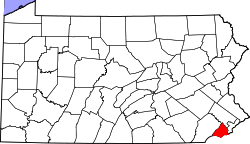 | |
| Boroughs | ||
| Townships | ||
| CDPs | ||
| Unincorporated communities |
| |
| Footnotes | ‡This populated place also has portions in an adjacent county or counties | |