Marowijne District
| Marowijne | |
|---|---|
| District | |
 | |
 Map of Suriname showing Marowijne district | |
| Coordinates: 5°46′N 56°19′W / 5.767°N 56.317°W | |
| Country | Suriname |
| Capital | Albina |
| Area | |
| • Total | 4,627 km2 (1,786 sq mi) |
| Population (2012 census) | |
| • Total | 18,294 |
| • Density | 4.0/km2 (10/sq mi) |
| Time zone | ART (UTC-3) |
Marowijne is a district of Suriname, located on the north-east coast. Marowijne's capital city is Albina, with other towns including Moengo and Wanhatti. The district borders the Atlantic Ocean to the north, French Guiana to the east, the Surinamese district of Sipaliwini to the south, and the Surinamese districts of Commewijne and Para to the west.
Marowijne's population is 20,250 and the district has an area of 4,627 km².
During the early 20th century, bauxite was discovered in Marowijne district, leading to a boom in mining that significantly enriched the entire country. The district also has a large tourism industry and is the location of oceanfront resorts.
Marowijne is also home to many Maroon palenques. The Maroons are descendants of slaves who escaped from their Dutch masters centuries ago, particularly slaves who escaped from Suriname's huge plantations during the 18th century. They established autonomy for their interior settlements by a 1785 peace treaty with the Netherlands, which was unable to conquer them.
Resorts
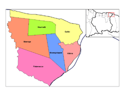
Marowijne is divided into six resorts (ressorten):
| Brokopondo District |  | |
|---|---|---|
| Commewijne District | ||
| Coronie District | ||
| Marowijne District | ||
| Nickerie District | ||
| Para District | ||
| Paramaribo District | ||
| Saramacca District | ||
| Sipaliwini District | ||
| Wanica District | ||
Coordinates: 5°46′14″N 54°19′29″W / 5.77056°N 54.32472°W