Maroubra, New South Wales
| Maroubra Sydney, New South Wales | |||||||||||||
|---|---|---|---|---|---|---|---|---|---|---|---|---|---|
 Maroubra Beach | |||||||||||||
| Coordinates | 33°56′58″S 151°14′37″E / 33.9495°S 151.2437°ECoordinates: 33°56′58″S 151°14′37″E / 33.9495°S 151.2437°E | ||||||||||||
| Population | 29,594 (2011 census)[1] | ||||||||||||
| Established | 1910[2] | ||||||||||||
| Postcode(s) | 2035 | ||||||||||||
| Time zone | AEST (UTC+10) | ||||||||||||
| • Summer (DST) | AEDT (UTC+11) | ||||||||||||
| Location | 10 km (6 mi) south of Sydney CBD | ||||||||||||
| LGA(s) | City of Randwick | ||||||||||||
| State electorate(s) | Maroubra | ||||||||||||
| Federal Division(s) | Kingsford Smith | ||||||||||||
| |||||||||||||
Maroubra is a beachside suburb in the Eastern Suburbs of Sydney, in the state of New South Wales, Australia. It is 10 kilometres south of the Sydney central business district in the local government area of the City of Randwick. Maroubra is the largest suburb in the area governed by Randwick City Council in both area and population.[2] Maroubra Junction is a locality in the centre of the suburb.
History
1800s
Maroubra is a local Aboriginal word meaning place of thunder. In 1861, the first house was built in the area by Humphrey McKeon. A number of other settlers arrived on the land in the 1870s to work on the wool scouring works located at the northern end of the bay.[3]
.jpg)
The suburb first made headlines on 6 May 1898, when the Hereward, a fully rigged iron ship weighing 1,513 tons, was caught by the gale force winds and shipwrecked at the northern end of Maroubra Beach while heading north toward Newcastle. The shipwreck remained on the beach for a number of years until a failed attempt to refloat it was made by building a coffer dam around the wreck. Hereward Street in Maroubra is named after the event.
1900s
Major residential development only began in the 1910s after Herbert Dudley, a real estate developer, subdivided the land into residential blocks. Herbert Dudley also lobbied for the extension of the tramline to Maroubra Junction in 1912, where he had built Dudley's Emporium which has just recently been redeveloped. More crown land was released for residential use in the 1920s and the tram line was extended to Maroubra Beach in 1921.
Between 1925 and 1934, the Olympia Motor Speedway was located in South Maroubra at the corner of Anzac Parade and Fitzgerald Avenue. However, due to the dangerous nature of the concrete track, a number of deaths occurred and it was closed after only nine years of operation. Coral Sea Park and surrounding estates was announced on the site in 1947 and formally completed in 1961. The estates and park was given its namesake from the 1942 battle; The battle of the Coral Sea.[4]
2000s
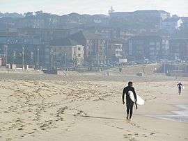
In 2005, Maroubra was named as one of the suburbs involved in the Cronulla Riots, after more than 100 cars were vandalised in relation to the riots between Middle Eastern and Anglo youth.[5] In 2006, Maroubra Beach became the second Australian beach to be named a National Surfing Reserve (the first beach being Bells Beach in Victoria).[6] It is also an incredibly popular place for people learning to surf[7] due to its beginner friendly conditions.
2010s
Maroubra Junction and surrounding areas
Maroubra Junction is one of the main shopping areas in the district and is home to Pacific Square shopping centre (built on the area once known as Stockland Mall, Maroubra). Pacific Square shopping centre has an outdoor eating area on Anzac Parade, Coles and Aldi supermarkets, Glamabags, many specialty shops as well as being home to the area's Australia Post outlet.[8] Commercial developments are also found along Anzac Parade, Maroubra Road and surrounding streets, including Dudley's Emporium which was the first shopping centre in Maroubra Junction built in 1912 and has been recently redeveloped.
Maroubra Beach and surrounds
There are also a handful of shopping districts besides Maroubra Junction including the areas surrounding Maroubra Beach. McKeon Street and Marine Parade are home to multiple cafes and restaurants, and other retail facilities such as surf shops, yoga schools, a chemist and newsagent, the Maroubra Seals Club and The Bay Hotel.
South Maroubra
South Maroubra Shopping Village, known as "The Village", is located in South Maroubra and is home to many well-known shops including a late night pharmacy, Walsh's Pharmacy as well as Maroubra's only Woolworths supermarket.It is also next door to the well known Sands Hotel. The Village and South Maroubra Village Green are home to the Christmas Carols every year.[9][10][11][12]
Hotels

Current
- Glasshouse (Since 1947) – The licence of the Golden Grove Hotel was transferred from Darlington to new premises on the corner of Anzac Parade and Boyce Road, Maroubra Junction in February 1947. The hotel has more recently changed its name to the Glasshouse Hotel.[13]
- The Sands Hotel (Since 1972) – A hotel in South Maroubra alongside South Maroubra Shopping Village.
- Maroubra Junction Hotel (Unknown Opening Date)- A hotel in Maroubra Junction across Maroubra Road from Pacific Square.
- Ocean View Tavern (Since 2010) – In an attempt to popularise the mostly vacant area surround Maroubra Beach, the Maroubra Bay Hotel premises was revitalised and re-opened under the name of the Ocean View Tavern.[14]
- Juniors @ The Junction (Since 2009) – The result of a merger with South Sydney Junior Rugby League Club (Kingsford) and the struggling Maroubra Returned and Services League (RSL) Club. The club is on the site of the former Maroubra RSL club on Anzac Parade and Haig Street.[15]
Former
- Maroubra Bay Hotel (1926–2010) – Popular after World War I due to the extension of the tram line to the beach, the construction of a promenade and bathing sheds. Due to a downturn in trade the hotel closed in early 2010.
- Trade Winds (1984–2002) – Maroubra Junction on Maroubra Road. 2002 saw the hotel converted into apartments. The Trade Winds Brasserie is all that's left of the old hotel.
- Maroubra RSL (2000[16]–2009) – The struggling Maroubra Returned and Services League (RSL) Club merged with South Sydney Junior Leagues Club in order to keep the premise open due to poor income. It was reopened under the name "Juniors @ The Junction".[15]
Transport
Roads
Anzac Parade leads directly from Moore Park to La Perouse through Maroubra Junction via Kensington and Kingsford. Anzac Parade begins at the end Flinders and Oxford Streets which leads traffic out of the CBD. Cleveland Street runs onto Anzac Parade connecting the inner-city suburbs such as Surry Hills, Darlington and Camperdown as well as Central Station and Railway Square to Maroubra.
Buses
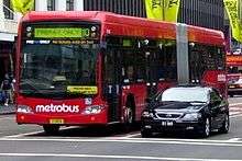
Regular bus services run from Maroubra Junction to the city including route numbers 394, 399, 396 and 397. The 394 and 399 originate from La Perouse and Little Bay (respectively) while 396 and 397 originate from Maroubra Beach and South Maroubra, respectively.
The 400 and 410 run from Maroubra Junction in two directions; Bondi Junction, Randwick and Waverley to the north and Eastgardens, the airport, Rockdale and Burwood to the south. Central Station and Railway Square can be accessed through the Railway Square buses (393 and 395) as well as the Metro10 bus service which goes through the inner-city, past Queen Victoria Building and continues along Broadway to provide services to the University of Sydney and Leichhardt. Other services run through Maroubra providing locals with routes into more suburban areas such as Coogee, South Coogee, and Randwick.
Light Rail
There is currently a campaign by the Randwick City Council, UNSW and Royal Randwick racecourse for a light rail to run down Anzac Parade past Sydney Football Stadium, Sydney Cricket Ground and ending at the University of NSW, with hopes to one day extend the network to Maroubra.[17]
Trams
The former Maroubra tram line opened from Anzac Parade to Maroubra Bay in 1921. The line branched off the main line to La Perouse at the intersection of Anzac Parade and Maroubra Road, travelling east along Maroubra Road, Cooper Street, French Street and Mons Avenue before terminating in a balloon loop in Marine Parade at Maroubra Bay Beach. The line was double track throughout, and passed through several tram reservations on its descent down to the beach. Direct services operated from Circular Quay and Railway Square. The line closed in 1961. The current route of bus 397 now covers this route.
Heritage listings
Due to the age of the suburb there are 34 sites formally recognised by the NSW Office of Environment and Heritage as providing a "sense of continuity and belonging to the place where we live".[18] None of these sites, however, have been protected under Section 136 of the NSW Heritage Act.[19]
Media
Maroubra is within the reporting and circulation boundaries of the South-Eastern Suburbs newspaper; "Southern Courier" which is owned and distributed by News Limited.
Maroubra is also within the reporting and circulation boundaries of The Beast, a monthly magazine for the beaches and bays of Sydney’s east. It covers local news, sport and the arts and each month. It features a different local celebrity on the cover.
Maroubra was home to the set of the television series Heartbreak High which was filmed at Maroubra Bay High School after its closure.
The German electronic musician Edgar Froese included a track called Maroubra Bay on his 1975 album Epsilon in Malaysian Pale, which was influenced by a visit to Maroubra during Tangerine Dream's 1975 Australian tour.
In 1963 "Little Pattie" reached No. 2 on the Australian Top40 with her hit EP singles "Stomping at Maroubra"and "He's My Blonde-Headed, Stompie Wompie, Real Gone Surfer Boy"
Sport and recreation
A number of well-known sporting teams represent the local area. One of them is the well known NRL club named the South Sydney Rabbitohs and Maroubra Lions some other teams are Maroubra Surf Life Saving Club, South Maroubra Surf Life Saving Club, Maroubra Bodyboard Club and Maroubra Surf Riders Club.
The South Maroubra Dolphins Winter Swimming Club and Maroubra Seals Winter Swimming Club swim at Wylie's Baths and compete against Bondi Icebergs Winter Swimming Club, Cottesloe Crabs, Cronulla Polar Bears Winter Swimming Club, Coolangatta Surf Life Saving Club, Clovelly Eskimos Winter Swimming Club, Bronte Splashers, Wollongong Whales and Coogee Penguins Winter Swimming Club in the Winter Swimming Association of Australia Championships[20]
Maroubra Beach is listed as a national surfing reserve, as a result, it has played host to many surfing competitions. The most notable of which was the 2004 Snickers Australian Open where then-six time world champion Kelly Slater won. The event was covered in the Bra Boys movie, Bra Boys: Blood is Thicker than Water.
Other events
Due to the large size of Maroubra beach, it has also been used for sports other than surfing. One of the more highly covered events was the 2007 Beach Cricket series which saw Maroubra Beach play home to Round Three of the series between Australia, England and West Indies. The round saw Australia and England progress to the finals which were played the following day, again at Maroubra.
Religion
Christian
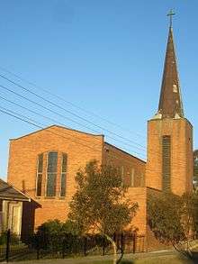
- Holy Family Catholic Church – originally St Aidan's Catholic Church
- St. Mary & St. Joseph Catholic Church
- Our Lady of the Annunciation Catholic Church
- St Johns Anglican Church
- St Edmund's Anglican Church (also known as Wild Street Church)
- Maroubra Baptist Church
- Salvation Army Maroubra
- Maroubra Presbyterian Church
- Maroubra Junction Uniting Church
- Maroubra Bay Uniting Church
- C3 Church Maroubra
Other
- AuGuang Maitreya
- Kingsford Maroubra Hebrew Orthodox Congregation[21]
Healthcare
Maroubra is located close to the Prince of Wales Hospital in Randwick. As a result, there a several clinics and out-patient services run by Prince of Wales Hospital located in Maroubra, such as the Maroubra Centre that provides support to people living with mental illness. Maroubra is also home to a NSW Ambulance station; located on Mons Avenue near Maroubra Beach.
Schools
Current
- St Spyridon College
- Lycée Condorcet (The International French School of Sydney)
- Maroubra Bay Public School
- Maroubra Junction Public School
- Mount Sinai College
- South Sydney High School
- St Aidan's Primary School
- St Mary St Joseph Primary School
- Marist College Pagewood
- Our Lady of the Annuciation Primary School
Closed
- Maroubra Junction High School
- Premises now in use by Lycée Condorcet
- Maroubra Bay High School
- Premises no longer existent – residential estate in place of former grounds. Famous for being the school used for the TV Series Heartbreak High.
- Brigidine College Maroubra
- Moved to Randwick and became Brigidine College Randwick. The grounds have since been redeveloped into St Brigid's Green, a retirement village.
Maroubra Beach and parklands

Maroubra Beach stretches for approximately 1 km on Maroubra Bay. Mahon Pool is located north of the beach, near Mistral Point. There are two surf clubs at Maroubra: Maroubra Surf Life Saving Club and South Maroubra Surf Life Saving Club. Arthur Byrne Reserve sits behind both these clubs. A skating park is located at the southern end of Maroubra Beach.
Maroubra has some large parklands, the most popular being the reserve along the waterfont at Maroubra Beach, called Arthur Byrne Reserve. The reserve has an enclosed children's playground to the north of the blue Pavilion building at North Maroubra, close to the car park. There are barbecue facilities and tables for picnickers. There are public ablution facilities inside the blue Pavilion building. Arthur Byrne Reserved is the home to the Oktoberfest/Fun Run every year.[22]

Heffron Park, on Fitzgerald Avenue and between Bunnerong Road and Robey Street is a particularly large park. It accommodates the Des Renford Aquatic Centre with indoor and outdoor pools, tennis courts, sports fields, parklands, and a two kilometre cycle track which is used for time trials and is accessible for public use at other times.
Nagle Park, on Wild Street between Walsh Avenue and Holden Street, is a flat parkland equipped for use as a sports facility. It is also a popular dog park, with dogs permitted off-lead.
Snape Park, on Snape Street between Hannan and Percival Streets is equipped with popular tennis facilities and sports fields and is frequently used for organised sporting events.
Central Park, at the corner of Cooper and Storey Streets, has a flat parkland with an excellent bicycle track for young children built of smooth concrete. This park also has playground equipment.
Coral Sea Park, south of Yorktown Parade, has a flat area that provides several sports fields. It has playground equipment at its south end.
Demographics
In the 2011 Census, there were 29,594 people in Maroubra. 44.0% were married and 10.1% were either divorced or separated. 31.7% of people had both parents born in Australia and 56.8% of people had both parents born overseas. 55.9% of people only spoke English at home. Other languages spoken at home included Greek 5.7%, Cantonese 5.3%, Mandarin 4.5%, Indonesian 3.4% and Russian 2.0%.[1]
The most common ancestries in Maroubra were Australian 16.3%, English 15.7%, Chinese 11.7%, Irish 7.5% and Greek 6.0%. 51.6% of people were born in Australia. The most common countries of birth were China (excludes SARs and Taiwan) 4.3%, Indonesia 3.5%, England 3.2%, Hong Kong (SAR of China) 2.2% and New Zealand 2.0%.[1]
The most common responses for religion were Catholic 29.9%, no religion 19.0%, Anglican 11.2%, Eastern Orthodox 9.0% and Judaism 5.5%.[1]
Notable residents
- Koby Abberton, surfer with Bra Boys
- Bob Carr, former New South Wales Premier
- Michael Daley, Current Member of the Maroubra State Electorate
- Tilly Devine, Sydney crime identity
- Alex Cullen, TV journalist and presenter
- Philip Curran, Maroubra United/Dreamboat
- Manu Feildel, Australian Television Show My Kitchen Rules judge
- John Flaus, Australian film academic and theorist, actor, anarchist and raconteur
- Karl Kruszelnicki, TV and radio science presenter and journalist
- Reni Maitua, NRL Player for the Parramatta Eels; former player for Canterbury-Bankstown Bulldogs and Cronulla Sharks
- John Norton, Newspaper editor
- Guy Sebastian, an Australian pop, R&B, and soul singer-songwriter. He was the winner of the first season of Australian Idol in 2003.[23]
- Yvonne Strahovski, Actress on Chuck
- John Sutton, NRL player for the South Sydney Rabbitohs
- David Warner, Australian cricketer
- Michael Whitney, TV personality (Sydney Weekender, Who Dares Wins) and former Test Cricket Player for the NSW Blues and Australia
See also
Footnotes
- 1 2 3 4 Australian Bureau of Statistics (31 October 2012). "Maroubra (State Suburb)". 2011 Census QuickStats. Retrieved 20 April 2015.
- 1 2 Randwick Council: History
- ↑ The Book of Sydney Suburbs, Compiled by Frances Pollon, Angus & Robertson Publishers, 1990, Published in Australia ISBN 0-207-14495-8, page 164
- ↑ Randwick City Council:Maroubra Speedway
- ↑ Race riots spread to suburbs. Sydney Morning Herald, 12 December 2005
- ↑ Maroubra beach declared national surfing reserve – ABC World Today
- ↑ Sydney.com
- ↑ Pacific Square Webpage
- ↑ Walsh's Pharmacy Website
- ↑ Woolworths Supermarket Store Locator
- ↑ Sand Hotel: Location
- ↑ http://www.maroubrachamber.com/chamber/pages/6/Community Maroubra Chamber: Events
- ↑ Sydney Morning Herald, 22 February 1947
- ↑ 'Maroubra beach hotel re-opens', Southern Courier 30/11/10
- 1 2 'Clubs fight to survive', Southern Courier 14/04/2009
- ↑ Startlocal.com.au: Maroubra RSL profile
- ↑ "Light Rail to Randwick". Randwick City Council. Retrieved 4 September 2011.
- ↑ "Heritage Branch – About Us". NSW Office of Environment and Heritage. Retrieved 4 February 2012.
- ↑ "Heritage Listings – Heritage Databases". NSW Office of Environment and Heritage. Retrieved 4 February 2012.
- ↑ http://www.wsaainc.com/
- ↑
- ↑ Maroubra Fun Run Website
- ↑ http://canberratimes.com.au/domain/real-estate-news/guy-sebastian-buys-in-maroubra-20131116-2xngt.html
References
Scott, Mark and Nolan, Tony, Maroubra: Golden Age of the 'Bra, Kingsclear Books, (Alexandra), 2014 ISBN 978-0-9876067-3-0
External links
| Wikimedia Commons has media related to Maroubra, New South Wales. |
 Maroubra travel guide from Wikivoyage
- Maroubra at DMOZ
- Maroubra Districts Chamber of Commerce