Marine protected area
Marine protected areas (MPA) are protected areas of seas, oceans, estuaries or large lakes. MPAs restrict human activity for a conservation purpose, typically to protect natural or cultural resources.[2] Such marine resources are protected by local, state, territorial, native, regional, national, or international authorities and differ substantially among and between nations. This variation includes different limitations on development, fishing practices, fishing seasons and catch limits, moorings and bans on removing or disrupting marine life. In some situations (such as with the Phoenix Islands Protected Area), MPAs also provide revenue for countries, potentially equal to the income that they would have if they were to grant companies permissions to fish.[3]
On 28 October 2016 in Hobart, Australia, the Convention for the Conservation of Antarctic Marine Living Resources agreed to establish the first Antarctic and largest marine park in the world encompassing 1.55 million km2 (600,000 sq mi) in the Ross Sea.[4] Other large MPAs are in the Indian, Pacific, and Atlantic Oceans in certain exclusive economic zones of Australia and overseas territories of France, the United Kingdom and the United States, with major (990,000 square kilometres (380,000 sq mi) or larger) new or expanded MPAs by these nations since 2012—such as Natural Park of the Coral Sea, Pacific Remote Islands Marine National Monument, Coral Sea Commonwealth Marine Reserve and South Georgia and the South Sandwich Islands Marine Protected Area. When counted with MPAs of all sizes from many other countries, as of August 2016 there are more than 13,650 MPAs, encompassing 2.07% of the world's oceans, with half of that area – encompassing 1.03% of the world's oceans – receiving complete "no-take" designation.[5]
Terminology
"MPA" is an umbrella term for protected areas that includes some area of marine landscape and/or biodiversity. The IUCN defines a marine protected area as:
"Any area of the intertidal or subtidal terrain, together with its overlying water and associated flora, fauna, historical and cultural features, which has been reserved by law or other effective means to protect part or all of the enclosed environment."[6]
An alternative is "a clearly defined geographical space, recognized, dedicated, and managed through legal or other effective means, to achieve the long term conservation of nature with associated ecosystem services and cultural values".[7]
United States Executive Order 13158 in May 2000 established MPAs, defining them as;
"Any area of the marine environment that has been reserved by federal, state, tribal, territorial, or local laws or regulations to provide lasting protection for part or all of the natural and cultural resources therein."[8]
The Convention on Biological Diversity defined the broader term of marine and coastal protected area (MCPA);
"Any defined area within or adjacent to the marine environment, together with its overlying water and associated flora, fauna, historical and cultural features, which has been reserved by legislation or other effective means, including custom, with the effect that its marine and/or coastal biodiversity enjoys a higher level of protection than its surroundings."[9]
Classifications

Several types of compliant MPA can be distinguished:
- A totally marine area with no significant terrestrial parts.
- An area containing both marine and terrestrial components, which can vary between two extremes; those that are predominantly maritime with little land (for example, an atoll would have a tiny island with a significant maritime population surrounding it), or that is mostly terrestrial.
- Marine ecosystems that contain land and intertidal components only. For example, a mangrove forest would contain no open sea or ocean marine environment, but its river-like marine ecosystem nevertheless complies with the definition.
IUCN offered seven categories of protected area, based on management objectives and four broad governance types.
| Cat | IUCN Protected Area Management Categories: |
|---|---|
| |
Strict nature reserve A marine reserve usually connotes "maximum protection", where all resource removals are strictly prohibited. In countries such as Kenya and Belize, marine reserves allow for low-risk removals to sustain local communities. |
| |
Wilderness area |
| |
National park Marine parks emphasize the protection of ecosystems but allow light human use. A marine park may prohibit fishing or extraction of resources, but allow recreation. Some marine parks, such as those in Tanzania, are zoned and allow activities such as fishing only in low risk areas. |
| |
Natural monuments or features Established to protect historical sites such as shipwrecks and cultural sites such as aboriginal fishing grounds. |
| |
Habitat/species management area Established to protect a certain species, to benefit fisheries, rare habitat, as spawning/nursing grounds for fish, or to protect entire ecosystems. |
| |
Protected seascape Limited active management, as with protected landscapes. |
| |
Sustainable use of natural resources |
Related protected area categories include the following;
- World Heritage Site (WHS) – an area exhibiting extensive natural or cultural history. Maritime areas are poorly represented, however, with only 46 out of over 800 sites.
- Man and the Biosphere – UNESCO program that promotes "a balanced relationship between humans and the biosphere". Under article 4, biosphere reserves must "encompass a mosaic of ecological systems", and thus combine terrestrial, coastal, or marine ecosystems. In structure they are similar to Multiple-use MPAs, with a core area ringed by different degrees of protection.[11]
- Ramsar site – must meet certain criteria for the definition of "Wetland" to become part of a global system. These sites do not necessarily receive protection, but are indexed by importance for later recommendation to an agency that could designate it a protected area.[12]
While "area" refers to a single contiguous location, terms such as "network", "system", and "region" that group MPAs are not always consistently employed."System" is more often used to refer to an individual MPA, whereas "region" is defined by the World Conservation Monitoring Centre as:
"A collection of individual MPAs operating cooperatively, at various spatial scales and with a range of protection levels that are designed to meet objectives that a single reserve cannot achieve."[13]
At the 2004 Convention on Biological Diversity, the agency agreed to use "network" on a global level, while adopting system for national and regional levels. The network is a mechanism to establish regional and local systems, but carries no authority or mandate, leaving all activity within the "system".[14]
No take zones (NTZs), are areas designated in a number of the world's MPAs, where all forms of exploitation are prohibited and severely limits human activities. These no take zones can cover an entire MPA, or specific portions. For example, the 1,150,000 square kilometres (440,000 sq mi) Papahānaumokuākea Marine National Monument, the world's largest MPA (and largest protected area of any type, land or sea), is a 100% no take zone.[15]
Related terms include; specially protected area (SPA), Special Area of Conservation (SAC), the United Kingdom's marine conservation zones (MCZs),[16] or area of special conservation (ASC) etc. which each provide specific restrictions.
Stressors
Stressors that affect oceans include "the impact of extractive industries, localised pollution, and changes to its chemistry (ocean acidification) resulting from elevated carbon dioxide levels, due to our emissions". MPAs have been cited as the ocean's single greatest hope for increasing the resilience of the marine environment to such stressors.[17] Well-designed and managed MPAs developed with input and support from interested stakeholders can conserve biodiversity and protect and restore fisheries.
Economics
MPAs can help sustain local economies by supporting fisheries and tourism. For example, Apo Island in the Philippines made protected one quarter of their reef, allowing fish to recover, jumpstarting their economy. This was shown in the film, Resources at Risk: Philippine Coral Reef.[18] A 2016 report by the Center for Development and Strategy found that programs like the United States National Marine Sanctuary system can develop considerable economic benefits for communities through Public–private partnerships.[19]
Management
Typical MPAs restrict fishing, oil and gas mining and/or tourism. Other restrictions may limit the use of ultrasonic devices like sonar (which may confuse the guidance system of cetaceans), development, construction and the like. Some fishing restrictions include "no-take" zones, which means that no fishing is allowed. Less than 1% of US MPAs are no-take.
Ship transit can also be restricted or banned, either as a preventive measure or to avoid direct disturbance to individual species. The degree to which environmental regulations affect shipping varies according to whether MPAs are located in territorial waters, exclusive economic zones, or the high seas. The law of the sea regulates these limits.
Most MPAs have been located in territorial waters, where the appropriate government can enforce them. However, MPAs have been established in exclusive economic zones and in international waters. For example, Italy, France and Monaco in 1999 jointly established a cetacean sanctuary in the Ligurian Sea named the Pelagos Sanctuary for Mediterranean Marine Mammals. This sanctuary includes both national and international waters. Both the CBD and IUCN recommended a variety of management systems for use in a protected area system. They advocated that MPAs be seen as one of many "nodes" in a network of protected areas.[20] The following are the most common management systems:

Seasonal and temporary management—Activities, most critically fishing, are restricted seasonally or temporarily, e.g., to protect spawning/nursing grounds or to let a rapidly reducing species recover.
Multiple-use MPAs—These are the most common and arguably the most effective. These areas employ two or more protections. The most important sections get the highest protection, such as a no take zone and are surrounded with areas of lesser protections.
Community involvement and related approaches—Community-managed MPAs empower local communities to operate partially or completely independent of the governmental jurisdictions they occupy. Empowering communities to manage resources can lower conflict levels and enlist the support of diverse groups that rely on the resource such as subsistence and commercial fishers, scientists, recreation, tourism businesses, youths and others.
MPA networks—"A group of MPAs that interact with one another ecologically and/or socially form a network".[22] These networks are intended to connect individuals and MPAs and promote education and cooperation among various administrations and user groups. "MPA networks are, from the perspective of resource users, intended to address both environmental and socio-economic needs, complementary ecological and social goals and designs need greater research and policy support".[22] Filipino communities connect with one another to share information about MPAs, creating a larger network through the social communities' support.[23] Emerging or established MPA networks can be found in Southeast Australia, Belize, the Red Sea, Gulf of Aden and Mexico.[22]
International efforts
The 17th International Union for Conservation of Nature (IUCN) General Assembly in San Jose, California, the 19th IUCN assembly and the fourth World Parks Congress all proposed to centralise the establishment of protected areas. The World Summit on Sustainable Development in 2002 called for
the establishment of marine protected areas consistent with international laws and based on scientific information, including representative networks by 2012.[24]
The Evian agreement, signed by G8 Nations in 2003, agreed to these terms. The Durban Action Plan, developed in 2003, called for regional action and targets to establish a network of protected areas by 2010 within the jurisdiction of regional environmental protocols.It recommended establishing protected areas for 20 to 30% of the world's oceans by the goal date of 2012. The Convention on Biological Diversity considered these recommendations and recommended requiring countries to set up marine parks controlled by a central organization before merging them. The United Nations Framework Convention on Climate Change agreed to the terms laid out by the convention, and in 2004, its member nations committed to the following targets;[25]
- By 2006 complete an area system gap analysis at national and regional levels.
- By 2008 address the less represented marine ecosystems, accounting for those beyond national jurisdiction in accordance.
- By 2009 designate the protected areas identified through the gap analysis.
- By 2012 complete the establishment of a comprehensive and ecologically representative network.
"The establishment by 2010 of terrestrial and by 2012 for marine areas of comprehensive, effectively managed, and ecologically representative national and regional systems of protected areas that collectively, inter alia through a global network, contribute to achieving the three objectives of the Convention and the 2010 target to significantly reduce the current late of biodiversity loss at the global, regional, national, and sub-national levels and contribute to poverty reduction and the pursuit of sustainable development."[27]
The UN later endorsed another decision, Decision VII/15, in 2006:
Effective conservation of 10% of each of the world's ecological regions by 2010.
– United Nations Framework Convention on Climate Change Decision VII/15[28]
Global treaties
The Antarctic Treaty System
On 7 April 1982, the Convention on the Conservation of Antarctic Marine Living Resources (CAMLR Convention) came into force after discussions began in 1975 between parties of the then-current Antarctic Treaty to limit large-scale exploitation of krill by commercial fisheries. The Convention bound contracting nations to abide by previously agreed upon Antarctic territorial claims and peaceful use of the region while protecting ecosystem integrity south of the Antarctic Convergence and 60 S latitude. In so doing, it also established a commission of the original signatories and acceding parties called the Commission for the Conservation of Antarctic Marine Living Resources (CCAMLR) to advance these aims through protection, scientific study, and rational use, such as harvesting, of those marine resources. Though separate, the Antarctic Treaty and CCAMLR, make up part the broader system of international agreements called the Antarctic Treaty System. Since 1982, the CCAMLR meets annually to implement binding conservations measures like the creation of 'protected areas' at the suggestion of the convention's scientific committee.
In 2009, the CCAMLR created the first 'high-seas' MPA entirely within international waters over the southern shelf of the South Orkney Islands. This area encompasses 94,000 square kilometres (36,000 sq mi) and all fishing activity including transhipment, and dumping or discharge of waste is prohibited with the exception of scientific research endeavors.[29] On 28 October 2016, the CCAMLR, composed of 24 member countries and the European Union at the time, agreed to establish the world's largest marine park encompassing 1.55 million km2 (600,000 sq mi) in the Ross Sea after several years of failed negotiations. Establishment of the Ross Sea MPA required unanimity of the commission members and enforcement will begin in December 2017. However, due to a sunset provision inserted into the proposal, the new marine park will only be in force for 35 years.[30]
Regional Organizations
CCAMLR
National Targets
Many countries have established national targets, accompanied by action plans and implementations. The UN Council identified the need for countries to collaborate with each other to establish effective regional conservation plans. Some national targets are listed in the table below[31]
| Country | Plan of action |
|---|---|
| American Samoa | 20% of reefs to be protected by 2010 |
| Australia – South Australia | 19 marine protected areas by 2010 |
| Bahamas | 20% of the marine ecosystem protected for fishery replenishment by 2010. 20% of coastal and marine habitats by 2015. |
| Belize | 20% of bioregions.
30% of Coral reefs. 60% of turtle nesting sites. 30% of Manatee distribution. 60% of American crocodile nesting. 80% of breeding areas. |
| Chile | 10% of marine areas by 2010. National network for organization by 2015. |
| Cuba | 22% of land habitat, including:
|
| Dominican Republic | 20% of marine and coastal by 2020. |
| Micronesia | 30% of shoreline ecosystems by 2020. |
| Fiji | 30% of reefs by 2015.
30% of water managed by marine protected areas by 2020. |
| Germany | 38% of water managed by the marine protected network. (no set date) |
| Grenada | 25% of nearby marine resources by 2020. |
| Guam | 30% of nearby marine ecosystem by 2020. |
| Indonesia | 100,000 km2 by 2010.
200,000 km2 by 2020. |
| Ireland | 14% of territorial waters as of 2009[32] |
| Jamaica | 20% of marine habitats by 2020. |
| Madagascar | 100,000 km2 by 2012. |
| Marshal Islands | 30% of nearby marine ecosystem by 2020. |
| New Zealand | 20% of marine environment by 2010. |
| North Mariana Islands | 30% of nearby marine ecosystem by 2020. |
| Palau | 30% of nearby marine ecosystem by 2020. |
| Peru | Marine protected area system established by 2015. |
| Philippines | 10% fully protected by 2020. |
| Senegal | Creation of MPA network. (no set date) |
| St. Vincent and the Grenadines | 20% of marine areas by 2020. |
| Tanzania | 10% of marine area by 2010; 20% by 2020. |
| United Kingdom | Establish an ecologically coherent network of marine protected areas by 2012. |
| United States – California | 29 MPAs covering 18% of state marine area with 243 square kilometres (94 sq mi) at maximum protection. |
National efforts
The marine protected area network is still in its infancy. As of October 2010, approximately 6,800 MPAs had been established, covering 1.17% of global ocean area. Protected areas covered 2.86% of exclusive economic zones (EEZs).[33] MPAs covered 6.3% of territorial seas.[34] Many prohibit the use of harmful fishing techniques yet only 0.01% of the ocean's area is designated as a "no take zone".[35] This coverage is far below the projected goal of 20%-30%[36][37] Those targets have been questioned mainly due to the cost of managing protected areas and the conflict that protections have generated with human demand for marine goods and services.[38][39]
Greater Caribbean
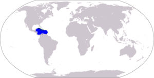

The Greater Caribbean subdivision encompasses an area of about 5,700,000 square kilometres (2,200,000 sq mi) of ocean and 38 nations. The area includes island countries like the Bahamas and Cuba, and the majority of Central America. The Convention for Protection and Development of the Marine Environment of the Wider Caribbean Region (better known as the Cartagena Convention) was established in 1983. Protocols involving protected areas were ratified in 1990. As of 2008, the region hosted about 500 MPAs. Coral reefs are the best represented.
Two networks are under development, the Mesoamerican Barrier Reef System (a long barrier reef that borders the coast of much of Central America), and the "Islands in the Stream" program (covering the Gulf of Mexico).[40]
Southeast Asia
Southeast Asia is a global epicenter for marine diversity. 12% of its coral reefs are in MPAs. The Philippines have some the world's best coral reefs and protect them to attract international tourism. Most of the Philippines' MPAs are established to secure protection for its coral reef and sea grass habitats. Indonesia has MPAs designed for tourism and relies on tourism as a main source of income.[18]
Philippines
The Philippines host one of the most highly biodiverse regions, with 464 reef-building coral species. Due to overfishing, destructive fishing techniques, and rapid coastal development, these are in rapid decline. The country has established some 600 MPAs. However, the majority are poorly enforced and are highly ineffective. However, some have positively impacted reef health, increased fish biomass, decreased coral bleaching and increased yields in adjacent fisheries. One notable example is the MPA surrounding Apo Island.[41]
Latin America
Latin America has designated one large MPA system. As of 2008, 0.5% of its marine environment was protected, mostly through the use of small, multiple-use MPAs.[42]
South Pacific
The South Pacific network ranges from Belize to Chile. Governments in the region adopted the Lima convention and action plan in 1981. An MPA-specific protocol was ratified in 1989. The permanent commission on the exploitation and conservation on the marine resources of the South Pacific promotes the exchange of studies and information among participants.[42]
The region is currently running one comprehensive cross-national program, the Tropical Eastern Pacific Marine Corridor Network, signed in April 2004. The network covers about 211,000,000 square kilometres (81,000,000 sq mi).[42]
One alternative to imposing MPAs on an indigenous population is through the use of Indigenous Protected Areas, such as those in Australia.
North Pacific
The North Pacific network covers the western coasts of Mexico, Canada, and the U.S. The "Antigua Convention" and an action plan for the north Pacific region were adapted in 2002. Participant nations manage their own national systems.[42] In 2010-2011, the State of California completed hearings and actions via the state Department of Fish and Game to establish new MPAs.
United States and Pacific Island Territories
President Barack Obama signed a proclamation on September 25, 2014, designating the world's largest marine reserve. The proclamation expanded the existing Pacific Remote Islands Marine National Monument, one of the world's most pristine tropical marine environments, to six times its current size, encompassing 490,000 square miles (1,300,000 km2) of protected area around these islands. Expanding the Monument protected the area's unique deep coral reefs and seamounts.[43]

In April 2009, the US established a United States National System of Marine Protected Areas, which strengthens the protection of US ocean, coastal and Great Lakes resources. These large-scale MPAs should balance "the interests of conservationists, fishers, and the public."[22] As of 2009, 225 MPAs participated in the national system. Sites work together toward common national and regional conservation goals and priorities. NOAA's national marine protected areas center maintains a comprehensive inventory[44] of all 1,600+ MPAs within the US exclusive economic zone. Most US MPAs.allow some type of extractive use. Fewer than 1% of U.S. waters prohibit all extractive activities.[45]
In 1981 Olympic National Park became a marine protected area. The total protected site area is 3,697 square kilometres (1,427 sq mi). 173.2 km2 of the area was an MPA.[46] The national system is a mechanism to foster MPA collaboration.[47] Sites that meet pertinent criteria are eligible to join the national system. Four entry criteria govern admission:
- Meets the definition of an MPA as defined in the Framework.
- Has a management plan (can be sitespecific or part of a broader programmatic management plan; must have goals and objectives and call for monitoring or evaluation of those goals and objectives).
- Contributes to at least one priority conservation objective as listed in the Framework.
- Cultural heritage MPAs must also conform to criteria for the National Register for Historic Places."[47]
In 1999, California adopted the Marine Life Protection Act, establishing the first state law requiring a comprehensive, science-based MPA network. The state created the Marine Life Protection Act Initiative. The MLPA Blue Ribbon Task Force and stakeholder and scientific advisory groups ensure that the process uses the science and public participation.
The MLPA Initiative established a plan to create California's statewide MPA network by 2011 in several steps. The Central Coast step was successfully completed in September, 2007. The North Central Coast step was completed in 2010. The South Coast and North Coast steps were expected to go into effect in 2012.[48]
United Kingdom and British Overseas Territories
United Kingdom
There are a number of marine protected areas around the coastline of the United Kingdom, known as Marine Conservation Zones in England, Wales, and Northern Ireland, Marine Protection Areas in Scotland.[49][50] They are to be found in inshore and offshore waters.[51]
British Overseas Territories
The United Kingdom is also creating marine protected reserves around several British Overseas Territories. The UK is responsible for 6.8 million square kilometres of ocean around the world, larger than all but four other countries.[52]
The Chagos Marine Protected Area in the Indian Ocean was established in 2010 as a "no-take-zone". With a total surface area of 640,000 square kilometres (250,000 sq mi), it was the world's largest contiguous marine reserve.[53][54] In March 2015, the UK announced the creation of a marine reserve around the Pitcairn Islands in the Southern Pacific Ocean to protect its special biodiversity. The area of 830,000 square kilometres (320,000 sq mi) surpassed the Chagos Marine Protected Area as the world's largest contiguous marine reserve, until the August 2016 expansion of the Papahānaumokuākea Marine National Monument in the United States to 1,510,000 square kilometres (580,000 sq mi).[55][56]
In January 2016, the UK government announced the intention to create a marine protected area around Ascension Island. The protected area will be 234,291 square kilometres (90,460 sq mi), half of which will be closed to fishing.[57]
Europe
The Natura 2000 ecological MPA network in the European Union included MPAs in the North Atlantic, the Mediterranean Sea and the Baltic Sea. The member states had to define NATURA 2000 areas at sea in their Exclusive Economic Zone.
Two assessments, conducted thirty years apart, of three Mediterranean MPAs, demonstrate that proper protection allows commercially valuable and slow-growing red coral (Corallium rubrum) to produce large colonies in shallow water of less than 50 metres (160 ft). Shallow-water colonies outside these decades-old MPAs are typically very small. The MPAs are Banyuls, Carry-le-Rouet and Scandola, off the island of Corsica.[58]
- Mediterranean Science Commission; proposed the creation of 7 marine protected areas ("peace parcs")[59][60]
Notable marine protected areas
- The Bowie Seamount Marine Protected Area off the coast of British Columbia, Canada.
- The Great Barrier Reef Marine Park in Queensland, Australia.
- The Ligurian Sea Cetacean Sanctuary in the seas of Italy, Monaco and France.
- The Dry Tortugas National Park in the Florida Keys, USA.
- The Papahānaumokuākea Marine National Monument in Hawaii.
- The Phoenix Islands Protected Area, Kiribati.[61]
- The Channel Islands National Marine Sanctuary in California, USA.[62]
- The Chagos Marine Protected Area in the Indian Ocean.[63]
- The Wadden Sea bordering the North Sea in the Netherlands, Germany, and Denmark.
Assessment

Managers and scientists use geographic information systems and remote sensing to map and analyze MPAs. NOAA Coastal Services Center compiled an "Inventory of GIS-Based Decision-Support Tools for MPAs." The report focuses on GIS tools with the highest utility for MPA processes.[45] Remote sensing uses advances in aerial photography image capture, pop-up archival satellite tags, satellite imagery, acoustic data, and radar imagery. Mathematical models that seek to reflect the complexity of the natural setting may assist in planning harvesting strategies and sustaining fishing grounds.[64]
Coral reefs
Coral reef systems have been in decline worldwide. Causes include overfishing, pollution and ocean acidification. As of 2013 30% of the world's reefs were severely damaged. Approximately 60% will be lost by 2030 without enhanced protection.[65] Marine reserves with "no take zones" are the most effective form of protection.[66] Only about 0.01% of the world's coral reefs are inside effective MPAs.[67]
Fish
MPAs can be an effective tool to maintain fish populations. The general concept is to create overpopulation within the MPA. The fish expand into the surrounding areas to reduce crowding, increasing the population of unprotected areas.[68] This helps support local fisheries in the surrounding area, while maintaining a healthy population within the MPA. Such MPAs are most commonly used for coral reef ecosystems.
One example is at Goat Island Bay in New Zealand, established in 1977. Research gathered at Goat Bay documented the spillover effect. "Spillover and larval export—the drifting of millions of eggs and larvae beyond the reserve—have become central concepts of marine conservation". This positively impacted commercial fishermen in surrounding areas.[69]
Another unexpected result of MPAs is their impact on predatory marine species, which in some conditions can increase in population. When this occurs, prey populations decrease. One study showed that in 21 out of 39 cases, "trophic cascades," caused a decrease in herbivores, which led to an increase in the quantity of plant life. (This occurred in the Malindi Kisite and Watamu Marian National Parks in Kenya; the Leigh Marine Reserve in New Zealand; and Brackett's Landing Conservation Area in the US.[70]
Success criteria
Both CBD and IUCN have criteria for setting up and maintaining MPA networks, which emphasize 4 factors:[71]
- Adequacy—ensuring that the sites have the size, shape, and distribution to ensure the success of selected species.
- Representability—protection for all of the local environment's biological processes
- Resilience—the resistance of the system to natural disaster, such as a tsunami or flood.
- Connectivity—maintaining population links across nearby MPAs.
Misconceptions
Misconceptions about MPAs include the belief that all MPAs are no-take or no-fishing areas. However, less than 1 percent of US waters are no-take areas. MPA activities can include consumption fishing, diving and other activities.
Another misconception is that most MPAs are federally managed. Instead, MPAs are managed under hundreds of laws and jurisdictions. They can be exist in state, commonwealth, territory and tribal waters.
Another misconception is that a federal mandate dedicates a set percentage of ocean to MPAs. Instead the mandate requires an evaluation of current MPAs and creates a public resource on current MPAs.[72]
Criticism
Some existing and proposed MPAs have been criticized by indigenous populations and their supporters, as impinging on land usage rights. For example, the proposed Chagos Protected Area in the Chagos Islands is contested by Chagossians deported from their homeland in 1965 by the British as part of the creation of the British Indian Ocean Territory (BIOT). According to Wikileaks CableGate documents,[73] the UK proposed that the BIOT become a "marine reserve" with the aim of preventing the former inhabitants from returning to their lands and to protect the joint UK/US military base on Diego Garcia Island.
Other critiques include: their cost (higher than that of passive management), conflicts with human development goals, inadequate scope to address factors such as climate change and invasive species.[38]
Recent research

In 2010, one study found that fish larvae can drift on ocean currents and reseed fish stocks at a distant location. This finding demonstrated that fish populations can be connected to distant locations through the process of larval drift.[74]
They investigated the yellow tang, because larva of this species stay in the general area of the reef in which they first settle.[75] The tropical yellow tang is heavily fished by the aquarium trade. By the late 1990s, their stocks were collapsing. Nine MPAs were established off the coast of Hawaii to protect them. Larval drift has helped them establish themselves in different locations, and the fishery is recovering.[75] "We've clearly shown that fish larvae that were spawned inside marine reserves can drift with currents and replenish fished areas long distances away," said coauthor Mark Hixon.[75]
See also
References
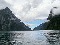
- ↑ "Milford Sound Marine Reserve". Protectedplanet.net. Retrieved 2012-06-07.
- ↑ "Marine Protected Areas". National Ocean Service. National Oceanic and Atmospheric Administration. Retrieved 2016-09-02.
- ↑ National Geographic Magazine, January 2011
- ↑ "CCAMLR to create world's largest Marine Protected Area". Convention for the Conservation of Antarctic Marine Living Resources. 28 October 2016. Retrieved 28 October 2016.
- ↑ "Explore". MPAtlas. Marine Conservation Institute. Retrieved 2016-09-02.
- ↑ "Marine protected areas, why have them?". IUCN. 2010-02-01. Retrieved 2012-06-07.
- ↑ "Towards Networks of Marine Protected Areas - The MPA Plan of Action for IUCN's World Commission on Protected Areas". IUCN. 2008-11-04. Retrieved 2012-06-07.
- ↑ "Nomination of Existing Marine Protected Areas to the National System of Marine Protected Areas and Updates to the List of National System Marine Protected Areas". Federalregister.gov. Retrieved 2012-06-07.
- ↑ Marine Protected Areas (MPA) (2010-10-15). "Areas of Biodiversity Importance: Marine Protected Areas, 2010". Biodiversitya-z.org. Retrieved 2012-06-07.
- ↑ Foreign and Commonwealth Office, New Protection for Marine Life, April, 2010 Archived July 2, 2011, at the Wayback Machine.
- ↑ "Man and the Biosphere Programme". UNESCO. Retrieved 2012-06-07.
- ↑ Information Sheet on Ramsar Wetlands Archived August 13, 2011, at the Wayback Machine.
- ↑ WDPA: Establishing Resilient Marine Protected Area Networks — Making It Happen, 2008
- ↑ UNEP: Marine Protected Areas and the Concept of Fisheries Refugia, 2006/
- ↑ "Papahānaumokuākea (Expansion) Marine National Monument, United States". MPAtlas. Marine Conservation Institute. Retrieved 2016-09-02.
- ↑ "Marine Conservation Zones". Naturalengland.org.uk. Retrieved 2012-06-07.
- ↑ Laffoley, D. d'A., (ed.) 2008. Towards Networks of Marine Protected Areas. The MPA Plan of Action for IUCN's World Commission on Protected Areas. IUCN WCPA, Gland, Switzerland. 28 pp.
- 1 2 Christie, P. and A.T. White. 2007. Best practices for improved governance of coral reef marine protected areas. Coral Reefs 26:1047-1056.
- ↑ Harary, David. "Joint-Value Creation Between Marine Protected Areas and the Private Sector" (PDF). thinkcds.org. Center for Development and Strategy. Retrieved 26 July 2016.
- ↑ "Marine Protected Area Networks". Unep-Wcmc. 2011-01-18. Retrieved 2012-06-07.
- ↑ "Asinara Natural Marine Reserve". Protectedplanet.net. Retrieved 2012-06-07.
- 1 2 3 4 Christie, P., and A. T. White. "Best Practices for Improved Governance of Coral Reef Marine Protected Areas." Coral Reefs 26.4 (2007): 1047-056. Print.
- ↑ Lowry, G. K., A. T. White, and P. Christie. "Scaling Up to Networks of Marine Protected Areas in the Philippines: Biophysical, Legal, Institutional, and Social Considerations." Coastal Management 37.3 (2009): 274-90. Print.
- ↑ Wells et al. 2008, p. 13
- ↑ UNWP-WCMC National and Regional Networks of Marine Protected Areas: A Review of Progress
- ↑ "Bunaken Marine Park". Protectedplanet.net. Retrieved 2012-06-07.
- ↑ "United Nations Framework Convention on Climate Change, Decision VII/28". Cbd.int. Retrieved 2012-06-07.
- ↑ "United Nations Framework Convention on Climate Change, Decision VII/15". Cbd.int. Retrieved 2012-06-07.
- ↑ "Protection of the South Orkney Islands southern shelf". https://www.ccamlr.org. Commission for the Conservation of Antarctic Marine Living Resources. Retrieved 29 October 2016. External link in
|website=(help) - ↑ "CCAMLR to create world's largest Marine Protected Area". Commission for the Conservation of Antarctic Marine Living Resources. 29 October 2016. Retrieved 29 October 2016.
- ↑ Wells et al. 2008, p. 15
- ↑ "Irish marine protected areas". Indexmundi.com. Retrieved 2012-06-07.
- ↑ "Global Ocean Protection: Present Status and Future Possibilities". Iucn.org. 2010-11-23. Retrieved 2012-06-07.
- ↑ "UN (2010) Millennium Development Goals Report – Addendum". Mdgs.un.org. Retrieved 2012-06-07.
- ↑ Christie, Patrick, and A.T White. "Best practices for improved governance of coral reef marine protected areas." (2007): 1048-1056. Print.
- ↑ Halpern, B. (2003). "The impact of marine reserves: do reserves work and does reserve size matter?". Ecological Applications. 13: S117– S137. doi:10.1890/1051-0761(2003)013[0117:TIOMRD]2.0.CO;2.
- ↑ No Take Areas Archived March 24, 2012, at the Wayback Machine.
- 1 2 Mora, C; Sale, P (2011). "Ongoing global biodiversity loss and the need to move beyond protected areas: A review of the technical and practical shortcoming of protected areas on land and sea" (PDF). Marine Ecology Progress Series. 434: 251–266. doi:10.3354/meps09214.
- ↑ Wooda, Louisa J.; Fisha, Lucy; Laughrena, Josh; Pauly, Daniel (2008). "Assessing Progress Towards Global Marine Protection Targets: Shortfalls in Information and Action". 42. Oryx: 340–351. doi:10.1017/S003060530800046X.
- ↑ Wells et al. 2008, p. 33
- ↑ Summary Report for MPAs in the Philippines
- 1 2 3 4 Wells et al. 2008
- ↑ President Obama Designates Largest Marine Monument 25 Sept 2014 Retrieved 25 Sept 2014
- ↑ MPA Inventory Archived March 28, 2010, at the Wayback Machine.
- 1 2 "Marine Protected Areas Government Website". Mpa.gov. 2012-05-07. Retrieved 2012-06-07.
- ↑ www.cognitiveDesign.net (1981-01-01). "Olympic National Park World Heritage Site - a Marine Protected Area in USA (contiguous states) - Overview". MPA Global. Retrieved 2012-06-07.
- 1 2 "Notices: Nomination of Existing Marine Protected Areas to the National System of Marine » Federal Register [FR Doc E9-31406]". Thefederalregister.com. Retrieved 2012-06-07.
- ↑ Department of Fish and Game. "http://www.dfg.ca.gov/mlpa/
- ↑ "Marine Protected Areas around the UK". The Wildlife Trusts. Retrieved 19 March 2015.
- ↑ "Protecting and sustainably using the marine environment". UK Government. 30 January 2015. Retrieved 19 March 2015.
- ↑ "Map". UK Marine Protected Areas Centre. Retrieved 19 March 2015."Marine Protected Areas in the UK". Joint Nature Conservation Committee. Retrieved 19 March 2015.
- ↑ "Conservationists call for UK to create world's largest marine reserve". The Guardian. 15 February 2015. Retrieved 4 January 2016.
- ↑ "Chagos Marine Reserve, British Indian Ocean Territory". Marine Reserves Coalition. Retrieved 19 March 2015.
- ↑ "Chagos Marine Reserve". Chagos Conservation Trust. Retrieved 19 March 2015.
- ↑ "World's Largest Single Marine Reserve Created in Pacific". National Geographic. World’s Largest Single Marine Reserve Created in Pacific. 18 March 2015. Retrieved 19 March 2015.
- ↑ "Pitcairn Islands get huge marine reserve". BBC. 18 March 2015. Retrieved 19 March 2015."Pitcairn Islands to get world's largest single marine reserve". The Guardian. 18 March 2015. Retrieved 19 March 2015.
- ↑ "Ascension Island to become marine reserve". BBC. 3 January 2016. Retrieved 3 January 2016.
- ↑ "Marine Protected Areas Conserve Mediterranean Red Coral". Science Daily. May 11, 2010. Retrieved June 11, 2010.
- ↑ "7 peace parcs proposed by CIESM". Magazine.nationalgeographic.nl. Retrieved 2012-06-07.
- ↑ "CIESM webpage". Ciesm.org. Retrieved 2012-06-07.
- ↑ "Conservation International – World's Largest Marine Protected Area Created in Pacific Ocean". Conservation.org. Retrieved 2012-06-07.
- ↑ Smith & Miller 2003.
- ↑ North Sea Marine Cluster. "Managing Marine Protected Areas" (PDF). NSMC. Retrieved 11 February 2013.
- ↑ Berezansky, L.; Idels, L.; Kipnis, M. (2011). "Mathematical model of marine protected areas". IMA Journal of Applied Mathematics. 76 (2): 312–325. doi:10.1093/imamat/hxq043. ISSN 0272-4960. Preprint: http://hdl.handle.net/10613/2741.
- ↑ Pandolfi, J.M.; et al. (2003). "Global trajectories of long-term decline of coral reef ecosystems". Science. 301 (301): 955–958. doi:10.1126/science.1085706.
- ↑ Hughes, T.P.; et al. (2003). "Climate change, human impacts, and the resilience of coral reefs". Science. 301 (301): 929–933. doi:10.1126/science.1085046.
- ↑ Mora C.; Andrèfouët,S; Costello,M. J.; Kranenburg,C; Rollo,A; Veron,J; Gaston,K. J.; Myers,R. A.; et al. (2006). "Coral reefs and the global network of Marine Protected Areas" (PDF). Science. 312 (5781): 1750–1751. doi:10.1126/science.1125295. PMID 16794065.
- ↑ Marine Protected Areas (Innri)
- ↑ Warne, Kennedy. "Saving the Sea's Bounty"] National Geographic. April 2007.
- ↑ MPA News, Vol. 6 No. 1, July 2004
- ↑ Wells et al. 2008, p. 17
The International Union for Conservation of Nature defines a protected area as:
"A clearly defined geographical space, recognized, dedicated, and managed, through legal or effective means, to achieve the long-term conservation of nature with associated ecosystem service and cultural value."
- ↑ Archived February 15, 2013, at the Wayback Machine.
- ↑ "WikiLeaks reveals U.S., British use marine reserves as tool of imperialism". Embassy London. 2009-05-15. Retrieved 2010-12-24.
- 1 2 Christie MR, Tissot BN, Albins MA, Beets3 JP, Jia Y, Ortiz DL, Thompson SE, Hixon MA (2010) Larval Connectivity in an Effective Network of Marine Protected Areas PLoS ONE, 5(12) doi:10.1371/journal.pone.0015715
- 1 2 3 Drifting Fish Larvae Allow Marine Reserves to Rebuild Fisheries ScienceDaily , 26 December 2010.
Citations
- Wells, Sue; Sheppard, V.; van Lavieren, H.; Barnard, N.; Kershaw, F.; Corrigan, C.; Teleki, K.; Stock, P.; Adler, E., (2008). "National and Regional Networks of Marine Protected Areas:A Review of Progress" (PDF). Master Evaluation for the UN Effort. World Conservation Monitoring Centre The Americas. Retrieved 2009-03-18.
- Smith, D; Miller, K A (2003). "Safe Harbors for our Future: An Overview of Marine Protected Areas.". In: SF Norton (ed). Diving for Science...2003. Proceedings of the American Academy of Underwater Sciences (22nd Annual Scientific Diving Symposium). Retrieved 2008-08-13.
- Australian Government, Department of the Environment and Water Resources (May 2007). "Growing up strong: The first 10 years of Indigenous Protected Areas in Australia" (PDF). Canberra: Australian Government. ISBN 0642553521. Retrieved 2008-05-08{{inconsistent citations}}
Further reading
- Fabio Spadi (2000), "Navigation in Marine Protected Areas: National and International Law", Ocean Development and International Law 31: 285–302.
- Markus J. Kachel (2008), Particularly Sensitive Sea Areas, Hamburg Studies on Maritime Affairs *Moustakas, A. & I. Karakassis. How diverse is aquatic biodiversity research?, Aquatic Ecology, 39, 367–375
- Moustakas, A. & I. Karakassis (in press). A geographic analysis of the published aquatic biodiversity research in relation to the ecological footprint of the country where the work was done. Stochastic Environmental Research and Risk Assessment, doi:10.1007/s00477-008-0254-2.
- Christie, Patrick, "Marine Protected Areas and Biological Successes and Social Failures in Southeast Asia." School of Marine Affairs and Henry M. Jackson School of International Studies. University of Washington. Washington. January 5, 2004.
External links
- MPAtlas.org is an online tool from the Marine Conservation Institute that provides information on the world’s protected areas and global MPA campaigns. Information comes from a variety of sources, including the World Database on Protected Areas (WDPA), and many regional and national databases.
- Marine protected areas are included on the WDPA, which, since 2010 is viewable via Protected Planet, an online interactive search engine hosted by the United Nations Environment Programme's World Conservation Monitoring Center (UNEP-WCMC).
- Protect Planet Ocean – Marine Protected Areas site
- A-Z of Areas of Biodiversity Importance: Marine Protected Areas
- MPA News: monthly news and analysis on marine protected areas worldwide
- Microdocs – 'The Short Attention Span Science Theater on Ecological Sustainability'
- CetaceanHabitat.org – Cetacean habitat directory for MPAs, national and international sanctuaries
- WhyFiles.org – Huge Pacific reserve formed in Hawaii
- WWF: An Overview of Marine Protected Areas in the UK
- Misconceptions concerning MPAs (NOAA)
- New Research shows massive increase in biomass and diversity in what has been called the best MPA in the world
- MPAtlas, a joint project of Marine Conservation Institute and the Waitt Foundation
- Cellular Automata Model of an MPA Fishery Wolfram Demonstrations Project — requires CDF player (free)

| Conservation biology |  | |
|---|---|---|
| Conservation areas |
| |
| Restoration | ||
| By taxa |
| |
| By country | ||
| Other |
| |