Mare Tranquillitatis
|
The Sea of Tranquility of the Moon | |
| Coordinates | 8°30′N 31°24′E / 8.5°N 31.4°ECoordinates: 8°30′N 31°24′E / 8.5°N 31.4°E |
|---|---|
| Diameter | 873 km (542 mi)[1][2] |
| Eponym | Sea of Tranquility |

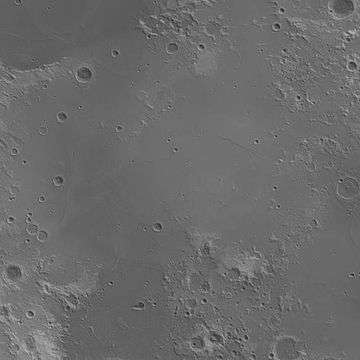
Mare Tranquillitatis (Latin for Sea of Tranquility or Sea of Tranquillity (see spelling differences)) is a lunar mare that sits within the Tranquillitatis basin on the Moon. The mare material within the basin consists of basalt formed in the intermediate to young age group of the Upper Imbrian epoch. The surrounding mountains are thought to be of the Lower Imbrian epoch, but the actual basin is probably Pre-Nectarian. The basin has irregular margins and lacks a defined multiple-ringed structure. The irregular topography in and near this basin results from the intersection of the Tranquillitatis, Nectaris, Crisium, Fecunditatis, and Serenitatis basins with two throughgoing rings of the Procellarum basin. Palus Somni, on the northeastern rim of the mare, is filled with the basalt that spilled over from Tranquillitatis.
This Mare has a slight bluish tint relative to the rest of the moon and stands out quite well when color is processed and extracted from multiple photographs. The color is likely due to higher metal content in the basaltic soil or rocks.[3]
Unlike many other maria, there is no mass concentration (mascon), or gravitational high, in the center of Mare Tranquillitatis. Mascons were identified in the center of other maria (such as Serenitatis or Imbrium) from Doppler tracking of the five Lunar Orbiter spacecraft in 1968.[4] The gravity field was mapped at higher resolution with later orbiters such as Lunar Prospector and GRAIL, which unveiled an irregular pattern.
 Topographic map
 Gravity map based on GRAIL
Naming
Mare Tranquillitatis was named in 1651 by astronomers Francesco Grimaldi and Giovanni Battista Riccioli in their lunar map Almagestum novum.[5][6]
Landings
In February 1965, the Ranger 8 spacecraft was deliberately crashed into the Mare Tranquillitatis, after successfully transmitting 7,137 close-range photographs of the Moon in the final 23 minutes of its mission.
Surveyor 5 landed in Mare Tranquillitatis on September 11, 1967, and was the fifth lunar lander of the unmanned Surveyor program.
This mare was also the landing site for the first manned landing on the Moon on July 20, 1969, at 20:18 UTC. After astronauts Neil Armstrong and Buzz Aldrin made a smooth touchdown in the Apollo 11 Lunar Module named Eagle, Armstrong told flight controllers on Earth, "Houston, Tranquility Base here. The Eagle has landed." The landing area at 0.8° N, 23.5° E has been designated Statio Tranquillitatis after Armstrong's name for it, and three small craters to the north of the base have been named Aldrin, Collins, and Armstrong in honor of the Apollo 11 crew.
Bays
Along the periphery of the mare are several bay-shaped features that have been given names: Sinus Amoris, Sinus Asperitatis, Sinus Concordiae, and Sinus Honoris.[7]
Views
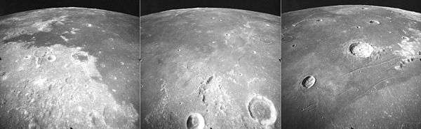
These are three views of Mare Tranquillitatis on the moon, taken by the mapping camera of the Apollo 17 mission in 1972, facing south-southwest from an average altitude of 111 km on Revolution 36 of the mission. At the left is the east side of Mare Tranquillitatis, with the craters Franz (bottom right), Lyell (dark floor, right of center), and Taruntius (upper left). The "bay" of dark mare (basalt) at left is Sinus Concordiae, with "islands" of older, light highland material. At right is the crater Cauchy, which lies between the Rupes Cauchy and Cauchy rille. The center photo shows the central mare with craters Vitruvius (lower right) and Gardner (bottom center). At the horizon are lighter highlands at the southern margin of the mare, near the Apollo 11 landing site. The crater Jansen is visible at the edges of both the center and right photos. The right photo shows the western mare, with the craters Dawes (lower left) and the large Plinius (43 km diameter), with the Plinius Rilles in the foreground. These photos were taken within minutes of each other as the Command Module America orbited the moon. The sun elevation drops from 46 degrees at left to 30 degrees at right.
In the arts

- Israeli psych-progressive rock band Jericho Jones recorded a song named "Mare Tranquilitatas" as the opening track of their UK album release (1971) Junkies, Monkeys & Donkeys. The band is also known as The Churchills.
- "Mare Tranquillitatis" is also the name of a composition of music by composer Vangelis on his 1976 album, Albedo 0.39 and is in reference to the selenographical term.
- "Sea of Tranquility" is also a song by the progressive rock band Barclay James Harvest, included in their 1977 album Gone to Earth. The composition was written by the band keyboardist Stuart "Woolly" Wolstenholme.
- Singer songwriter Tommy Shaw (best known for his work with the rock band Styx) is associated with a number of references to the Sea of Tranquility. Tranquility Base Songs is his publishing company. He called his farm Tranquility Base Farms. A number of his songs mention Tranquility Base or simply "tranquility." Examples include: "Boat on the River", "And all roads lead to Tranquility Base" (from the 1979 album Cornerstone), "Everything Is Cool" – "We are a Sea of Tranquillity" (from the 1999 album Brave New World), and "These Are the Times" – "We know the end will bring tranquility" (from the 2003 album Cyclorama).
- Sea of Tranquillity is the title of a 1994 novel by Paul Russell.
- Six Finger Satellite included a song named "Sea of Tranquility, Parts 1 & 2" from their 1998 album Law of Ruins.
- The Dutch stoner rock/space rock band 35007 released a 2001 EP named Sea of Tranquility.
- Dutch producer Maarten van der Vleuten/In-Existence released a song titled "Mare Tranquillitatis" on his album Vow Of Silence released on Tonefloat in 2005.
- Howard Korder wrote a play called Sea of Tranquility.
- The Brazilian rock band from the 80s RPM mentions the Sea of Tranquillity in their hit song "Radio Pirata".
- "Sea of Tranquillity" is a song by space ambient artist, John Stanford.
- The Sea of Tranquility is the name of a book by Mark Haddon, author of the best-selling The Curious Incident of the Dog in the Night-Time.
- The Sea of Tranquility is the name of a book by Katja Millay.
- Transmissions from The Sea of Tranquility is the name of the music album by The Samples, released September 30, 1997.
- The Houston, Texas based progressive metal band Galactic Cowboys recorded a song named "Sea of Tranquility" as the sixth track on their 1991 self-titled debut album.
- The Hardcore Punk band Jeromes Dream released a song called "Remember the Sea of Tranquility on their split 7" with Usurp Synapse.
- In the 1987 film "Can't Buy Me Love", Ronald Miller (played by Patrick Dempsey) describes the Sea of Tranquility to Cindy Mancini (played by Amanda Peterson) while viewing it through a telescope on their final date.
- In the anime Log Horizon 2, Mare Tranquillitatis is the name of the sea inside the dimension where characters go when they die.
- Mare Tranquillitatis is the name of a 2016 song by Adam Young.
Gallery
 Map of Mare Tranquillitatis, showing the landing sites of Apollo 11, Apollo 17, Apollo 16, and Surveyor 5. To the southeast is Mare Fecunditatis, to the northeast is Mare Crisium, to the northwest is Mare Serenitatis, and to the south is Mare Nectaris.
 Buzz Aldrin salutes the U.S. flag on Mare Tranquillitatis during Apollo 11 in 1969.
References
- ↑ "Moon Mare/Maria". Gazetteer of Planetary Nomenclature. USGS Astrogeology. Retrieved 2010-08-20.
- ↑ "Mare Tranquillitatis". Nasa.
- ↑ How to capture the color of the Moon
- ↑ P. M. Muller, W. L. Sjogren (1968). "Mascons: Lunar Mass Concentrations". Science. 161 (3842): 680–684. doi:10.1126/science.161.3842.680.
- ↑ The Face of the Moon. Kansas City, MO: Linda Hall Library. 1989. p. 7.
- ↑ "Mare Tranquillitatis naming origin". Lunar Planetary Institute.
- ↑ Wood, Chuck (2006-08-10). "Is it Love or a Sinus Infection?". Lunar Photo of the Day. Retrieved 2006-08-10.