Marajó
Coordinates: 0°59′S 49°35′W / 0.983°S 49.583°W
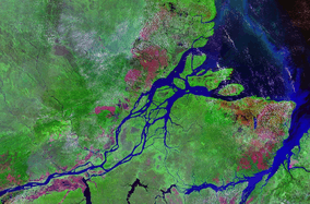 A satellite view of Marajó | |
 Marajó | |
| Geography | |
|---|---|
| Location | Amazon River |
| Coordinates | 0°59′S 49°35′W / 0.983°S 49.583°W |
| Area | 40,100 km2 (15,500 sq mi) |
| Area rank | 35th |
| Length | 297 km (184.5 mi) |
| Width | 204 km (126.8 mi) |
| Highest elevation | 40 m (130 ft) |
| Highest point | Breves (city) |
| Administration | |
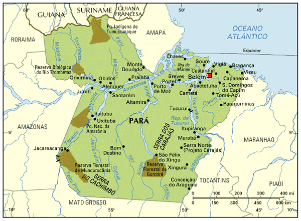
| State | Pará |
| Macroregion | Marajó |
| Largest settlement | Breves (pop. 99,223) |
| Demographics | |
| Population | 250,000 |
Marajó (Portuguese pronunciation: [ˈiʎɐ dʒi maɾaˈʒɔ]) is an island located at the mouth of the Amazon River in Brazil. It is part of the state of Pará.[1] Marajó is the largest fluvial island in the world and the second largest island in South America. With a land area of 40,100 square kilometres (15,500 sq mi) Marajó is comparable in size to Switzerland. It is approximately 295 kilometres (183 mi) long and 200 kilometres (120 mi) wide.[1]
The island is known for the pororoca, a tidal bore phenomenon in the river that creates large waves reaching 4 m (13 ft) in height. It is a tourist destination, especially among surfing enthusiasts.
Geography
The northeast coastline of Marajó faces the Atlantic Ocean. The outflow from the Amazon between January and July is so great that the sea at the mouth is made up of fresh water for some distance from shore. The city of Belém lies to the south across the southern fork (also called the Pará River) of the river's mouth.[2] The island sits almost directly on the equator.
Together with smaller neighboring islands, separated from Marajó by rivers, it forms the Marajó Archipelago, with an aggregate area of 49,602 square kilometres (19,151 sq mi).[3] The archipelago is contained in the 59,985 square kilometres (23,160 sq mi) Marajó Archipelago Environmental Protection Area, a sustainable use conservation unit established in 1989 to protect the environment of the delta region.[4]
Large parts of the islands are flooded during the rainy season because of higher water levels of the Amazon River along the coast and heavy rainfall in the interior. Marajó is almost entirely flat. During the rainy season, much of the island becomes flooded as a large lake.[2]
The east side of the island is dominated by savanna vegetation. There are large fazendas with animal husbandry.[2] This is also the location of Lake Arari, which has an area of 400 square kilometres (150 sq mi) but shrinks by 80% during the dry season.[5] There are large herds of domesticated water buffalo on the island.[2] The west side of the island is characterized by Várzea forests and small farms. Lumber and açaí are produced there.
To the north of the large savanna area are palm swamps, mainly with Buriti Palm (Mauritia flexuosa) and Euterpe oleracea. During the rainy season, the swamps are flooded one meter high. Little is known about the ecology of these swamps.
There are 20 large rivers on the island. Because of the changing water levels and regular seasonal flooding, many settlements are built on stilts (Palafitas).
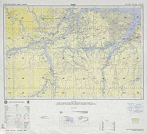
Municipalities
The most important towns are in the southeast of the island: Soure, Salvaterra, and the largest city, Breves. They feature a basic touristic infrastructure and are popular because of the generous, lightly populated beaches. The city of Soure, on the island's Atlantic Coast, serves as an entry point to the island via its ferry link to Belem.
The island is shared by 16 municipalities of three microregions:
- Microregion of Arari:
- Microregion of Furos de Breves:
- Microregion of Portel:
History
The island was the site of an advanced pre-Columbian society, the Marajoara culture, which existed from approximately 400 B.C. to 1600 A.D. The island has been a center of archaeological exploration and scholarship since the 19th century.[2] Scholars from the 1980s forward have divided the pre-Columbian period into the Ananatuba phase (ca. 1100 B.C.–ca. 200 B.C.), the Mangueiras phase (ca. 1000 B.C.–ca. 100 A.D.), the Formiga phase (ca. 100 A.D.-400 A.D.), the Marajoará phase (ca. 400 AD-1200 A.D.), and the Aruã phase (1200 A.D.-1500 A.D.).[2]
Marajó had a population of approximately 40,000 people until the arrival of the Portuguese in the 16th century. The population lived in homes with tamped earth floors. They were organized into matrilineal clans. Tasks were divided by sex, age, and skill level.
The arrival of the Europeans was catastrophic to the indigenous population of the island; 90% died due to high mortality from Eurasian infectious diseases; they lacked immunity against these diseases, which had become endemic in European and Asian cities.[6]
But, in the 1918–1919 pandemic worldwide of the Spanish influenza, Marajó was the only major populated area not to have any documented cases of the illness.[7]
The island is also the location of the Roman Catholic Territorial Prelature of Marajó.
References
- 1 2 "Marajó Island". Encyclopaedia Britannica. Encyclopaedia Britannica Inc. 2014. Retrieved 2014-12-17.
- 1 2 3 4 5 6 Araujo Costa, Costa (2014). "Marajó". Grove Art Online. Oxford, UK: Oxford University Press. Retrieved 2014-12-17.
- ↑ Development Plan for Marajó, Document of the Government of Brazil Archived July 6, 2011, at the Wayback Machine.
- ↑ APA Arquipélago do Marajó (in Portuguese), ISA: Instituto Socioambiental, retrieved 2016-06-27
- ↑ Prof. "Pará Histórico: Índios no Pará". Parahistorico.blogspot.com. Retrieved 2014-06-23.
- ↑ Lobato, Sidney da Silva (2012). Amapá: experiências fronteiriças. Coleção Estudos Amazônicos. História (in Portuguese) (1a ed.). Belém, Pará: Editora Estudos Amazônicos. pp. 7–8.
- ↑ Ryan, Jeffrey, ed. Pandemic influenza: emergency planning and community preparedness. Boca Raton : CRC Press, 2009. p. 24
External links
| Wikimedia Commons has media related to Marajó. |
 Ilha do Marajó travel guide from Wikivoyage
- Marajó Island and Pará state at V-Brazil.com