Maple, Ontario
| Maple | |
|---|---|
| Neighbourhood | |
|
Wonder Mountain at Canada's Wonderland is an unusual landmark in Maple. | |
 Location within Ontario | |
| Coordinates: 43°51′14″N 79°30′47″W / 43.85389°N 79.51306°WCoordinates: 43°51′14″N 79°30′47″W / 43.85389°N 79.51306°W | |
| Country | Canada |
| Province | Ontario |
| Regional municipality | York Region |
| City | Vaughan |
| Government | |
| • Mayor | Maurizio Bevilacqua |
| Time zone | EST (UTC−5) |
| • Summer (DST) | EDT (UTC−4) |
| Forward sortation area | L6A |
| Area code(s) | 905 and 289 |
| NTS Map | 030M13 |
| GNBC Code | FDKOV |

Maple is a high-growth suburban community, part of the city of Vaughan, Ontario in York Region, northwest of Toronto. As an unincorporated area, it does not have clearly defined geographic boundaries, but it grew around the former village of Maple, centred at the intersection of Major Mackenzie Dr and Keele St in Vaughan.
Geography
The west branch of the Don River rises to the northwest and flows 1 km west of Maple. Several creeks are to the east and the Black Creek begins slightly west of Vellore. The Oak Ridges Moraine is to the northeast which supplies a lot of water to the Greater Toronto Area.
Black Creek flows in the west, the Don River flows to the northern and the eastern part. York University Keele Campus lies to the south of Steeles Avenue, within the city of Toronto.
Climate
Maple has a continental climate moderated by the Great Lakes and influenced by warm, moist air masses from the south, and cold, dry air from the north.
| Climate data for Maple | |||||||||||||
|---|---|---|---|---|---|---|---|---|---|---|---|---|---|
| Month | Jan | Feb | Mar | Apr | May | Jun | Jul | Aug | Sep | Oct | Nov | Dec | Year |
| Record high °C (°F) | 13.0 (55.4) |
13.0 (55.4) |
24.0 (75.2) |
30.0 (86) |
33.0 (91.4) |
35.0 (95) |
37.5 (99.5) |
35.0 (95) |
30.0 (86) |
25.0 (77) |
21.0 (69.8) |
14.0 (57.2) |
37.5 (99.5) |
| Record low °C (°F) | −27.0 (−16.6) |
−26.0 (−14.8) |
−23.0 (−9.4) |
−9.5 (14.9) |
−3.0 (26.6) |
5.0 (41) |
7.0 (44.6) |
4.0 (39.2) |
−1.5 (29.3) |
−6.5 (20.3) |
−15.0 (5) |
−26.0 (−14.8) |
−27 (−16.6) |
| Average precipitation mm (inches) | 55.4 (2.181) |
48.6 (1.913) |
62.1 (2.445) |
62.1 (2.445) |
81.2 (3.197) |
84.8 (3.339) |
72.9 (2.87) |
101.6 (4) |
85.7 (3.374) |
71.5 (2.815) |
76.6 (3.016) |
62.4 (2.457) |
864.9 (34.051) |
| Source: Environment Canada[1] | |||||||||||||
Transportation

Maple is accessed by its central cross streets, Major Mackenzie Drive and Keele Street. The nearest major highway exit is 3 km west at Highway 400 and Major Mackenzie with access also at Highway 400 and Rutherford Rd.
The industrial areas are south and west of Maple, closer to Highway 407, and the Canadian National yards north of Highway 7 (Ontario). Maple is located 13 km NE of Woodbridge, 11 km E of Kleinburg 8 km S of King City, 6.5 km from downtown Richmond Hill 12 km NW of Thornhill N of Highway 401, and SSE of Barrie.
Maple is accessed by the GO Transit Barrie commuter line, with rail stations at Maple and Rutherford GO stations. Toronto Transit Commission, York Region Transit, and GO Transit buses serve the area. The Maple GO Station, built in 1903 by the Grand Trunk Railroad, is a federally designated a heritage railway station.[2]
Maple formerly had a small airport in the west, the Maple Airport, which closed down in 1987.[3] The runways ran diagonally like the letter x, the runway from northwest to southeast was the longer, and the other ran southwest to northeast. Streets like Avro, Lockheed, and Mustang on the site of the airport are named after airplanes.
In 2006 Maple gained bus-rapid-transit service under York Region's Transit (YRT) system.
History
The founding families of Maple were the Noble and the Rupert families. The Nobles settled around the present Major Mackenzie Drive and Keele Street intersection in the early half of the 19th century. In 1852 the town was called Noble’s Corner after Joseph Noble, the first Postmaster. Later, a Doctor Rupert lived in Maple and was such a respected member of the community that the town’s name was changed to Rupertsville. Local folklore associates the name "Maple" with the numerous Maple trees once found along Keele Street in the town. Maple was dominated for most of the 19th century by the more prosperous towns of Sherwood and Teston. Keele Street was then a boggy swamp area that forced most travelers to take alternate routes. Once the Ontario, Huron, and Simcoe Railway built a line through Maple, the town began to grow. The station was then called Richmond Hill. The Canadian National Railway bought the line in early 1900 and the station was renamed Maple.[4]
Maple, as a centre of agriculture, was enhanced with the proximity of the CNR line, as well as the growing urban development of Toronto. A major Ontario Dept. of Lands and Forests Office was situated here in the 1960s. Housing developments began in the 1960s in the southwest, as well as replacement of homes damaged in the August 1962 fire and explosion at an Industrial Propane Depot. Massive housing developments did not began until the 1980s in the northwest nearer McNaughton. In the mid-1980s to the late-1980s between the Don River and the CN line south to Rutherford.
A gravel pit was in the area north of Major Mackenzie and from the CN line to Dufferin Street. This became the Keele Valley Landfill, which was owned and operated by Metropolitan Toronto and later by the city of Toronto, and began receiving much of the GTA's garbage when the Beare Road Landfill in Scarborough reached capacity and was decommissioned. The landfill was closed on New Year's Eve 2002 when it had reached its capacity. The site has become reserved for the "Eagle's Nest" golf course, and other developments which will occur in the future once the buried waste decomposes sufficiently.[5]
Larger housing developments began to pop up near Teston between the 400 and Weston and Kirby near Pine Valley and Greenock near Weston and Teston and to the northeast near Bathurst and Teston with a golf course.
Canada's Wonderland first opened in 1981.[6]
Maple's proximity to Toronto and its major transportation corridors, and Vaughan's own political support for development, have led to the heavy development and heavy population growth. In 1993, housing development began in the area of what was the Maple Airport and to the northwest. In 1995, it expanded to the western part of Maple. Between 1997 and 1999, urban developments reached the northwestern part of Maple and Melville and the Don to the train tracks. Developments also reached the northeastern part and the southeastern part. Megalot houses began developing northeast of Maple near Dufferin in the late-1990s. The housing developments began up to the Highway 400 in the northwest. Housing developments have begun near Vellore.
As of 2001, developments reached the northwestern part as far as Highway 400, Teston Road, the CN line and the southwest. Most of the housing developments in the early-2000s reached Pine Valley Drive in the southwest in Vellore Village and Vellore Woods. The housing and urban developments is currently in the west between Highway 400 and Weston and Major Mackenzie and will reach to Teston.
Most recently there is a new subdivision being developed in the eastern part of Maple between bounded by Dufferin, Major Mackenzie and Rutherford Road. The name of the area is Thornberry Woods/Eagle Hills/Mackenzie Chase. Some of the builders include Greenpark Homes, Treasure Hill Homes, Tiffany Park Homes, Royal Pine Homes, Century Grove Homes, Primont Homes, Edenbrook Homes and Fernbrook Homes and Remington Homes (Thornhill Valley). Some of the street names like "Peter Rupert Avenue" reflect the history of Maple. This new area is directly south of Eagle's Nest Golf Course. This area known as Block 18 has just started development. Its proximity to Richmond Hill, Thornhill (also part of Vaughan) and the Golf Course are making the area very high demand and it is showing in the prices. "Upper Thornhill" (a misnomer name, given to the area by developers for marketing purposes) bounded by Dufferin to the west, Bathurst to the east, Major Mac to the south and Teston to the north is popularly considered a part of Maple.
Outside Maple, Vellore to the southwest used to serve as the municipal office for Vaughan until the late-20th century when it was moved to Maple. Today, the old town hall of Vaughan is a landmark.
The Lebovic Jewish Community Campus has been built to the north west of Bathurst St. and Rutherford Rd. intersection, almost at the border with the Thornhill.
Maple is home to one of the largest mosques in Canada. Baitul Islam Mosque is located on Jane Street south of Teston Road, where a planned subdivision named Peace Village was established in 1999.[7]
Political
Maple is within the Ontario provincial electoral riding of Vaughan, and the MPP is Steven Del Duca.[8] Maple is in the federal riding of King-Vaughan and the MP is Deb Schulte[9]
Nearest communities
- Concord, south
- Woodbridge, west
- Kleinburg, north west
- King City, north
- Richmond Hill, east
- Thornhill, southeast
Notable people
- Max Aitken, better known as First Baron Beaverbrook, was born in the St Andrew's Presbyterian Church Manse in 1879. His father left for a congregation in Newcastle New Brunswick the following year. There is a plaque outside the Church, noting that as Lord Beaverbrook, he donated a carillon.
- Massimo Bertocchi, Olympic decathlete.[10]
- Luca Caputi - ice hockey player IK Oskarshamn of the Swedish HockeyAllsvenskan
- Justin DiBenedetto - ice hockey player
- Phil Di Giuseppe - ice hockey player drafted into the NHL as the 38th draft pick in 2012 by the Carolina Hurricanes.
- Lucas Lessio - ice hockey player drafted into the NHL as the 56th draft pick in 2011 by the Phoenix Coyotes.
- Mendelson Joe - artist was raised in Maple.
- Gordon Kirkland - award-winning author and syndicated columnist attended George Bailey Public School and Joseph A. Gibson Public School in Maple.
- Anthony Luciani - ice hockey player for the Toledo Walleye of the ECHL
- Tyler Medeiros - a teen singer born in Maple.
- Andi Petrillo - sports anchor was raised in Maple.
- Dr. Fredrick William Routley - practiced medicine in Maple from 1909 to 1912. He was the Chief Executive Officer of the Canadian Red Cross for 27 years. In 1923 he developed the Blue Cross Plan which was put into effect in Ontario in 1941. Dr. Routley also helped establish the Ontario Hospital Association in 1923.[11]
- Martina Sorbara, lead singer and songwriter of Juno-Award winning band Dragonette; grew up on a farm in Maple.[12]
- Stuck On Planet Earth - a Canadian independent rock band
References
- ↑ Environment Canada
- ↑ "Former Canadian National Railway Station". Canada's Historic Places. Parks Canada. Retrieved 10 April 2016.
- ↑ "Maple Airport Part of Vibrant Past » Canadian Military History". militarybruce.com. Retrieved 2016-05-11.
- ↑ https://www.vaughan.ca/services/vaughan_archives/historyofvaughan/VaughanDocuments/A%20Brief%20History%20of%20Maple.pdf
- ↑ Innovasium. "Eagles Nest Golf Club: Frequently Asked Questions". www.eaglesnestgolf.com. Retrieved 2016-05-07.
- ↑ Canuck, Theme Park (2012-03-30). "Canada's Wonderland Park History". Theme Park Canuck. Retrieved 2016-05-07.
- ↑ "Peacevillage.ca".
- ↑ "Legislative Assembly of Ontario | Members (MPPs) | Current MPPs | Hon Steven Del Duca, MPP (Vaughan)". www.ontla.on.ca. Retrieved 2016-05-07.
- ↑ http://www.parl.gc.ca/Parliamentarians/en/members/Deborah-Schulte(88799)
- ↑ "Massimo Bertocchi is Beijing Bound". Yorkregion.com. July 25, 2008.
- ↑ https://www.vaughan.ca/services/vaughan_archives/historyofvaughan/VaughanDocuments/A%20Brief%20History%20of%20Maple.pdf
- ↑ Melvin, Charlie (March 20, 2003). "Culture: Singer With a Grand Passion for Creation; Martina Sorbara Has More Than One String To Her Bow". The Free Library.
- 1. ^ "Online Plaque Guide: Lord Beaverbrook 1879-1964". The Ontario Heritage Foundation. Retrieved 2006-04-12.
| Municipality | |
|---|---|
| Culture and services | |
| Education |
|
| Government |
|
| Transportation | |
| Sport | |
| |
Largest city: Toronto | ||
| Regions | 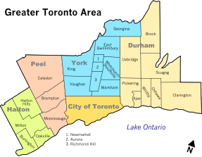 | |
| Cities | ||
| Towns | ||
| Townships and municipalities | ||