Manjeshwar
| Manjeshwar മഞ്ചേശ്വരം ಮಂಜೇಶ್ವರ Manjeshwara/Manjeshwaram | |
|---|---|
| Town Panchayath | |
|
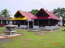
Jain Temple Manjeshwar | |
| Nickname(s): The land of seven languages | |
| Coordinates: 12°43′35″N 74°53′13″E / 12.72639°N 74.88694°ECoordinates: 12°43′35″N 74°53′13″E / 12.72639°N 74.88694°E | |
| Country | India |
| State | Kerala |
| District | Kasaragod |
| Named for | Manjula Kshetra |
| Government | |
| • Body | Block Panchayath |
| Area | |
| • Total | 24.4 km2 (9.4 sq mi) |
| Population (2011) | |
| • Total | 41,515 |
| • Density | 1,700/km2 (4,400/sq mi) |
| Languages | |
| • Official | Malayalam |
| Time zone | IST (UTC+5:30) |
| PIN | 671323 |
| Telephone code | 4998 |
| Vehicle registration | KL-14 |
Manjeshwar (Malayalam : മഞ്ചേശ്വരം Kannada : ಮಂಜೇಶ್ವರ) is a town at the northern tip of the Indian state of Kerala, bordering Karnataka. It is a coastal town in Kasaragod district.


Languages
Manjeshwar is also known as "The land of seven languages"(i.e. Natives here speak Malayalam, Kannada, Tulu, Beary bashe, Konkani, Urdu and English) and there are also settlers who speak Hindi and Tamil languages. It is 21 km from Mangalore city. Shrimath Anantheshwara Temple is situated in Manjeshwar. In 2007, the government set up a Tulu academy. It is historically known for its 1,200-year-old Srimath Anantheshwara Temple, which is mentioned in the Sahyadri Khand of the Skanda Purana. This is among the very few temples having a puranic background. Manjeswaram assembly constituency is part of Kasaragod (Lok Sabha constituency)
Demographics
The Manjeshwar Census Town has population of 8,742 of which 4,178 are males while 4,564 are females as per report released by Census India 2011.
Population of Children with age of 0-6 is 1149 which is 13.14% of total population of Manjeshwar (CT). In Manjeshwar Census Town, Female Sex Ratio is of 1092 against state average of 1084. Moreover, Child Sex Ratio in Manjeshwar is around 995 compared to Kerala state average of 964. Literacy rate of Manjeshwar city is 92.91% lower than state average of 94.00%. In Manjeshwar, Male literacy is around 97.53% while female literacy rate is 88.75%.[1]
Villages in Manjeshwar Area
- Manjeshwaram,Vorkadi, Meenja, Paivalike and Enmakaje
- Mangalpadi, Kumbla and Puthige
Climate
The monsoon rains during the months of June to September. The spring season occurs during the month of November to January. The summer or dry season falls between the month of February to May. There is an unnamed river that joins the Arabian sea here, thus making the river and sea rich with water life.
Economy / agriculture
Economy of Manjeshwar is mainly attributed to agriculture and fishing. The region has got fertile land and rich water resources. Most of the people who own land cultivate coconut plantation. Crabs and sea shells are widely available and the people here have developed many special recipes with these beautiful sea food. About 95% of the population of Manjeshwar entirely depend on the city of Mangalore for their basic needs and hence the economy of Mangalore has direct bearing on the economy of this region.
Education
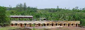
GPM Government College, Manjeshwaram has been sanctified by the name of the legendary literary luminary Rashtrakavi Manjeshwaram Govinda Pai. In October 1990, the college got transferred to the present and permanent abode in the Hosabettu village of Manjeshwar, which forms the northern border of Kerala State.
- Other Schools and Colleges
- Sirajul Huda English medium high School, Manjeshwar
- Sri Vani Vijaya Higher Secondary School, Kodlamogaru.
- Govt. Higher Secondary School, Kunjathur, Manjeshwar
- Govt. High School, Bangra Manjeshwar
- Udaya High School, Manjeshwar
- SAT School Manjeshwar
Transportation
Local roads have access to National Highway No.66 which connects to Mangalore in the north and Calicut in the south. The nearest railway station is Manjeshwar on Mangalore-Palakkad line. There is an airport at Mangalore.
Places of worship


- Chathurmukha Basati : This ancient Jain temple belongs to 12th century. This temple houses four idols of Jain gurus Adinatha, Shantinatha, Chandraprabha and Mahavira facing to the four directions.[2]
- Parswanatha Basati : This ancient Jain temple belongs to 14th century. Idols of Parswanatha, Padmavati Devi, Khusmandini(Ambika) Devi and Saraswati are present in this temple.[3]
- Shrimath Anantheshwar Gudi
- Shri Keertheshwara Gudi
- Shri Kanila Bhagavathi Gudi
- Shri Shanischara Mandir
- Shri Nithyananda Mandir
- Shri Kanwathirtha
- Sri Arasu Manjishnar Daivastana Udyawara
- Our Lady of Mercy Church Manjeshwar
- Infant Jesus Church
- Badriya Masjid
- Ahmadiyya Muslim Jama'at Masjid
- Safa Juma Masjid,Kunjathur
- Karoda Masjid at Main Junction Manjeshwar.
- Bilal Masjid
- Firdous Masjid
- Pandial Jumma Masjid
- Muhiyiddeen Jumma Masjid
Politics
Manjeswaram assembly constituency is part of Kasaragod (Lok Sabha constituency).[4]
Health
Manjeshwar is one of the areas with large number of HIV patients. 970 HIV cases were registered in Kasaragod district. Ten HIV deaths were reported from Kasaragod district within a short period of two months in 2016. There is no special facility or docotors for HIV patients in this area. HIV affected areas in Kasaragod include Dharmathadka, Nileshwaram, Manjeshwar, Bhandiyod, Vellarikundu, Kasaragod town and Padannakkad.[5]
See also
References
- ↑ "India 2011 census". Retrieved 25 September 2015.
- ↑ http://ajaysekher.net/2011/05/13/jain-temples-manjeswaram-jainism-kerala/
- ↑ http://ajaysekher.net/2011/05/13/jain-temples-manjeswaram-jainism-kerala/
- ↑ "Assembly Constituencies - Corresponding Districts and Parliamentary Constituencies" (PDF). Kerala. Election Commission of India. Retrieved 2008-10-18.
- ↑ http://english.mathrubhumi.com/health/health-news/10-hiv-deaths-reported-in-kasargod-dist-within-2-months-english-news-1.1315218
External links
| Wikimedia Commons has media related to Manjeshwar. |
- Birds eye view maps of Manjeshwar. (Courtesy: Wikimapia)
- Shrimath Anantheshwar Temple, Manjeshwar