Manitou Lake (Saskatchewan)
| Manitou Lake | |
|---|---|
 North-West Bay | |
| Location | Manitou Lake No. 442, Saskatchewan |
| Coordinates | 52°43′N 109°43′W / 52.717°N 109.717°WCoordinates: 52°43′N 109°43′W / 52.717°N 109.717°W |
| Type | Endorheic |
| Primary inflows | Eyehill Creek |
| Catchment area | 3,000 km2 (1,200 sq mi) |
| Basin countries | Canada |
| Surface area | 78 km2 (30 sq mi) |
| Islands | Manitou Island |
| Settlements | Marsden, Neilburg |
| References | [1][2][3] |
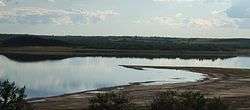
Manitou Lake is a salt-water lake in Western Saskatchewan near the Alberta border west of North Battleford. Because the lake is endorheic and quite salty there are no fish in the lake. Manitou Island in the centre of the lake is now connected to the southern shore as the water level has lowered.
Description
The lake is fed from Eyehill Creek on the south end, as well as many small springtime meltwater tributaries. The lake overflows to the north into the Battle River, although this has only happened once since European settlers first arrived in the area (approximately 1905). Lake levels were relatively constant until 1980, and have been declining rapidly since then, approximately one meter every six years. Less annual snowfall is blamed for most of this trend, and there is also heavier utilization of the Eyehill Creek system by urban, industrial, and agricultural users.
There is very little development on the lake although on the North-West Bay near the Suffern Lake Regional Park (Manitou Section) there is a golf course, cabins and a Bible Camp. The communities of Marsden and Neilburg are nearby to the north on Highway 40.
References
- ↑ "Natural Resources Canada-Canadian Geographical Names (Manitou Lake)". Retrieved 2015-02-06.
- ↑ "Atlas of Canada Toporama". Retrieved 2015-02-06.
- ↑ "IBA Canada (Community Conservation Plan for the Manitou Lake Important Bird Area)" (PDF). 2001. Retrieved 2015-02-06.