Huron-Manistee National Forests
| Huron-Manistee National Forests | |
|---|---|
|
IUCN category VI (protected area with sustainable use of natural resources) | |
|
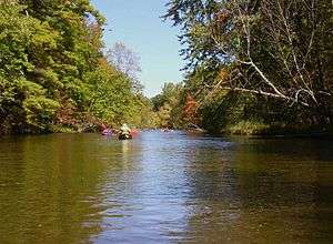
Canoes on the Pere Marquette River in Manistee National Forest. | |
 Map showing National Forests in Michigan. | |
| Location | Lower Peninsula, Michigan |
| Coordinates |
Huron 44°34′N 83°59′W / 44.57°N 83.99°W Manistee 43°51′N 85°57′W / 43.85°N 85.95°W |
| Area |
Total - 978,906 acres (3,960 km2) Huron - 438,584 acres (1,770 km2) Manistee - 540,322 acres (2,190 km2)[1] |
| Established |
Huron - 1909 Manistee - 1938 |
| Governing body | U.S. Forest Service |
| Website | Huron-Manistee National Forests |
The Huron-Manistee National Forests are two national forests combined in 1945 for administration purposes and which comprise 978,906 acres (3,960 km2) [2] of public lands, including 5,786 acres (23 km2) of wetlands, extending across the northern lower peninsula of Michigan. The Huron-Manistee National Forests provide recreation opportunities for visitors, habitat for fish and wildlife, and resources for local industry. The headquarters for the forests is in Cadillac, Michigan.
History

The Huron National Forest was established in 1909 and the Manistee National Forest in 1938. In 1945, they were administratively combined, although they are not adjacent. Huron has about 44.8% of the combined area, whereas the larger Manistee has about 55.2%.
The Huron National Forest is prone to many forest fires, for the most part due to the domination of the jack pine trees in the forests, which are extremely flammable. The soil is very sandy, which tends to dry out the vegetation and resources located within the forest.
In 2010, the Meridian Boundary Fire burned over 8,500 acres (3,400 ha) in and near the Huron District of the Huron National Forest. The fire destroyed 13 homes, damaged two others, and destroyed or damaged 46 outbuildings.[3]
Features
The Huron-Manistee boasts thousands of lakes and miles of sparkling rivers and streams. The nationally known Pere Marquette and Au Sable Rivers offer quality canoeing and fishing.
Over 330 miles (531 km) of trails are available for hiking on the Huron-Manistee National Forests.
The Huron-Manistee National Forests are a tourist attraction to many campers. You do not need a permit to camp on the National Forest campgrounds. However, some do require that one pays a reservation or camping fee. A wood permit is required to cut firewood on National Forest System Lands if one chooses to do so as well. These campgrounds are not gated or closed during the off-season, but they are also not maintained or plowed in the winter. Please check the conditions report on the main recreation page of the USDA.gov webpage for a listing of these campgrounds. Dispersed and Primitive camping are also allowed almost anywhere within the Forests, unless otherwise posted closed and/or "No Camping".[4]
The Manistee National Forest portion is located in northwest lower Michigan. It has varying but largely sandy terrain covered with trees. There are numerous lakes and frontage on Lake Michigan. The area is popular for fishing, camping, boating, snowmobiling, cross-country skiing and hunting. The North Country Trail passes through it. It has a total area of 540,187 acres (2,190 km2). In descending order of land area it lies in parts of Lake, Newaygo, Wexford, Manistee, Mason, Oceana, Muskegon, Mecosta, and Montcalm counties. There are local ranger district offices located in Baldwin and Manistee.
The Manistee Forest is not one continuous mass but is broken by private property and towns. Much of the land had been abandoned by logging companies after being logged off a century ago.
The Nordhouse Dunes Wilderness is a unique feature in the Manistee portion. This relatively small area of 3,450 acres (14 km2), situated on the east shore of Lake Michigan is one of the few wilderness areas in the U.S. with an extensive lake shore dunes ecosystem. Most of the dunes are 3500 to 4000 years old and some stand about 140 feet (43 m) higher than the lake. The Nordhouse Dunes are interspersed with woody vegetation such as juniper, jack pine and hemlock. There are many small water holes and marshes dotting the landscape and dune grass covers many of the dunes. The beach is wide and sandy.
The Huron National Forest portion is in northeast lower Michigan. Its southern boundary is approximately at the latitude of Manistee's northern boundary. It has a total area of 438,538 acres (1,770 km2). It lies in parts of Oscoda, Alcona, Iosco, Crawford, and Ogemaw counties. There are local ranger district offices in Mio and Oscoda.
The Bull Gap ORV Trail is located in the Huron portion. It contains 115 miles (185 km) of ORV trails.
The threatened Kirtland's warbler nests in the area, and tours are available, subject to time restrictions.[5]
References
- ↑ "Land Areas of the National Forest System" (PDF). U.S. Forest Service. January 2012. Retrieved 20 June 2012.
- ↑ Table 6 - NFS Acreage by State, Congressional District and County - United States Forest Service - September 30, 2007
- ↑ Hamilton, Chris. "Why and where do fires start (in the Huron National Forest)?". University of Wisconsin–Madison. Retrieved 2013-07-24.
- ↑ "Huron-Manistee National Forests - Camping & Cabins". United States Forest Service. Retrieved 2013-07-24.
- ↑ Tours, Huron-Manistee National Forest.
| Wikimedia Commons has media related to Huron-Manistee National Forests. |