Manila Municipal Airport
| Manila Municipal Airport | |||||||||||
|---|---|---|---|---|---|---|---|---|---|---|---|
 | |||||||||||
| IATA: MXA – ICAO: KMXA – FAA LID: MXA | |||||||||||
| Summary | |||||||||||
| Airport type | Public | ||||||||||
| Owner | City of Manila | ||||||||||
| Serves | Manila, Arkansas | ||||||||||
| Elevation AMSL | 242 ft / 74 m | ||||||||||
| Coordinates | 35°53′40″N 090°09′16″W / 35.89444°N 90.15444°WCoordinates: 35°53′40″N 090°09′16″W / 35.89444°N 90.15444°W | ||||||||||
| Map | |||||||||||
 MXA Location of airport in Arkansas | |||||||||||
| Runways | |||||||||||
| |||||||||||
| Statistics (2010) | |||||||||||
| |||||||||||
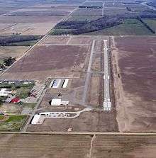
Manila Municipal Airport (IATA: MXA, ICAO: KMXA, FAA LID: MXA) is a public-use airport located two nautical miles (4 km) northeast of the central business district of Manila, in Mississippi County, Arkansas, United States. It is owned by the City of Manila.[1]
This airport is included in the FAA's National Plan of Integrated Airport Systems for 2011–2015, which categorized it as a general aviation facility.[2]
Facilities and aircraft
Manila Municipal Airport covers an area of 630 acres (255 ha) at an elevation of 242 feet (74 m) above mean sea level. It has one runway designated 18/36 with an asphalt surface measuring 4,200 by 60 feet (1,280 x 18 m).[1]
For the 12-month period ending July 31, 2010, the airport had 31,100 aircraft operations, an average of 85 per day: 99.7% general aviation and 0.3% military. At that time there were 13 aircraft based at this airport: 93% single-engine and 0% multi-engine.[1]
References
- 1 2 3 4 FAA Airport Master Record for MXA (Form 5010 PDF). Federal Aviation Administration. Effective 25 August 2011.
- ↑ "2011–2015 NPIAS Report, Appendix A (PDF, 2.03 MB)" (PDF). 2011–2015 National Plan of Integrated Airport Systems. Federal Aviation Administration. 4 October 2010. External link in
|work=(help)
External links
- Aerial image as of 21 January 2002 from USGS The National Map
- FAA Terminal Procedures for MXA, effective December 8, 2016
- Resources for this airport:
- FAA airport information for MXA
- AirNav airport information for MXA
- ASN accident history for MXA
- FlightAware airport information and live flight tracker
- SkyVector aeronautical chart for MXA