Manicaland Province
| Manicaland | |
|---|---|
| Province | |
 Manicaland, Province of Zimbabwe | |
| Country | Zimbabwe |
| Capital | Mutare |
| Area | |
| • Total | 36,459 km2 (14,077 sq mi) |
| Population (2012 census) | |
| • Total | 1,752,698 |
| • Density | 48/km2 (120/sq mi) |
Manicaland is a province of Zimbabwe.
Location
The province is bordered by Mashonaland East Province to the north, the Republic of Mozambique to the east, Masvingo Province to the south and southwest and Midlands Province to the west.[1] The provincial capital, Mutare (pop:184,205),[2] lies approximately 265 kilometres (165 mi), by road, southeast of Harare, the capital of Zimbabwe and the largest city in that country.[3]
Overview
It has an area of 36,459 square kilometres (14,077 sq mi),[4] and a population of approximately 1.57 million, as of 2004.[5] The city of Mutare is the provincial capital.
Background
The name derives from the fact that the area has been occupied in recent history by the Manyika people. The Manyika are a Shona sub-tribal grouping with their own language variant, the Manyika language.
Districts
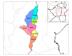
The province is subdivided into seven rural districts and three town/councils:
- Buhera
- Chimanimani
- Chipinge
- Makoni
- Mutare (in the center)
- Mutasa
- Nyanga (in the northeast of the province).
- Mutare City Council
- Chipinge Town Council
- Makoni Town Council
The people
Manicaland is the second most populated province in Zimbabwe. It has a population of about 1,755,000 which constitutes about 13.5% of the country's total population.
The people of Manicaland speak Shona, but different districts have own sub-dialects. For example, Mutasa District uses the Manyika sub-dialect. In Makoni District, the people use the Maungwe dialect, Chipinge, the Ndau and Mutare, the Bocha and Jindwi dialects.
The majority of people practise their own traditional way of worshiping, but also practice Christianity about 65%. The majority falling under the traditional churches: Methodist Church, Seventh-day Adventist Church, the Anglican Church and the Roman Catholic Church. Pentecostal churches are have big followings in the urban areas of Mutare and a few growth points. Some fall under the Apostolic Churches. A higher proportion of the Apostolic followers in Mutare and Buhera district and polygamy is quite prevalent among church members.
Schools in Manicaland
Manicaland boasts of some of the best performing schools in the country. Schools such as St Augastines (Tsambe), St Faith's School, Rusape (Fisco-'Madetere') (Currently the best performing school 2012 at 'O' level and 'A'level in Zimbabwe), Marist Brothers (Nyanga High), St Marys, Bonda High, Emmanuel High, Kriste Mambo, Mutare Boys' High School, Mutare Girls High (The Shumbas), St Dominics Mutare, Marange High, Hartzell High, Lydia Chimonyo, Sakubva High, Dangamvura High. These have produced exceptional results over the years and a great number of academics renowned internationally.
The privately run Africa University provides some relief albeit to a lesser extent it simply cannot absorb the huge numbers of school leavers with good passes.
In general, in Manicaland, there is a school within a 5 kilometres (3.1 mi) radius. There are numerous primary and secondary schools scattered across the province. The distribution of schools by district is shown in the table below.
| District | Primary | Secondary |
|---|---|---|
| Buhera | 140 | 55 |
| Chimanimani | 68 | 24 |
| Chipinge | 125 | 40 |
| Makoni | 170 | 60 |
| Mutare | 172 | 67 |
| Mutasa | 72 | 27 |
| Nyanga | 75 | 25 |
| Total | 822 | 298 |
Demographics
| Historical population | ||
|---|---|---|
| Year | Pop. | ±% |
| 1992 | 1,537,676 | — |
| 2002 | 1,568,930 | +2.0% |
| 2012 | 1,752,698 | +11.7% |
| Source: Zimbabwe National Statistics Agency (ZIMSTAT) | ||
Places of Interest
- Troutbeck, Manicaland
- Nyanga
- Marange diamond fields
- Vumba
- Chimanimani
- Hot Springs
- Osborne Dam
- Smallbridge Dam
- Birchenough Bridge
- Mutarazi Falls and "Mudhebdheb" suspension bridges
See also
References
External links
| Wikimedia Commons has media related to Manicaland Province. |
- Energy Sector Background for Manicaland Province
- Manicaland Publicity Association
- The Catholic Church In Manicaland 1896-1996
Coordinates: 19°00′S 32°30′E / 19.000°S 32.500°E