Manhattan Avenue
Manhattan Avenue is the name of two streets in New York City.
Brooklyn
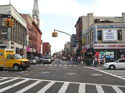
Manhattan Avenue is a north-south thoroughfare in the Brooklyn neighborhoods of Greenpoint and Williamsburg. It is the major shopping street in Greenpoint while it is mostly residential in Williamsburg. The stretch through Greenpoint is also called Little Poland for its high concentration of Polish culture and of Polish-named businesses and signage. The northern end was formerly connected to Long Island City, Queens by the Vernon Boulevard Bridge across Newtown Creek and the southern end is at Broadway. The southern part of the avenue is one-way northbound while the portion in Greenpoint is bidirectional. The IND Crosstown Line of the New York City Subway (G train) runs under Manhattan Avenue north of McCarren Park, and has two stations, Nassau Avenue and Greenpoint Avenue.
Prior to the consolidation of Williamsburg and Greenpoint into the city of Brooklyn in 1855, what is now Manhattan Ave. existed in two unconnected segments. The segment in Williamsburg was called Ewen Street (signs can still be seen in the masonry of some buildings) and the segment in Greenpoint was named Orchard Street below Greenpoint Avenue and Union Avenue above. These were connected near McCarren Park and renamed Manhattan Ave. This was just one of several street name changes made in an attempt to better integrate the street systems of the different cities and towns after the merger.
Manhattan
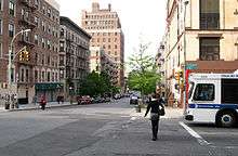
Not included in the original Commissioners' Plan of 1811, Manhattan Avenue in Manhattan Valley lies between Columbus Avenue (9th Ave.) and Central Park West/Frederick Douglass Boulevard (8th Ave.), extending from 100th Street to 124th Street, at which point it merges with St. Nicholas Avenue. It saw its first buildings in 1885, a group of row houses on its western side. These buildings were brick with stone and terra-cotta trim.[1] The now defunct New York Cancer Hospital, a landmark since 1976,[1] is nearby on Central Park West.
There are two historic districts on this avenue. Manhattan Avenue between West 120th and 123rd Streets was designated a National Historic District in 1992.[2][3] The Manhattan Avenue–West 120th–123rd Streets Historic District[4] lies on the western edge of Central Harlem. It is composed of 113 contributing brownstone and brick row houses on four short blocks between 120th and 123rd streets bounded by Morningside and Manhattan Avenues.[5] Additionally, a Manhattan Avenue Historic District between West 105th & West 106th Streets, including 101-137 and 120-140 Manhattan Avenue was designated by the New York City Landmarks Preservation Commission on May 15, 2007.[6]
References
- 1 2 Christopher, Gray (28 November 1999). "Streetscapes/Manhattan Avenue Between 104th and 106th Streets; 1880's Brick Row Houses With a Bostonian Air". The New York Times. Retrieved 26 August 2012.
- ↑ National Register of Historical Places - New York (NY). http://www.nationalregisterofhistoricplaces.com/ny/New+York/districts.html
- ↑ National Register Nomination Report. http://www.architecturaltrust.org/images/documents/reports/Report_NR_manhattan_ave120-123.pdf
- ↑ Historic District Map http://www.architecturaltrust.org/images/documents/reports/Map_manhattan_ave120-123.pdf
- ↑ Manhattan Avenue/West 120th-123rd Streets Historic District. http://www.architecturaltrust.org/new-york/manhattan/manhattan-ave-west-120-123rd-st
- ↑ Manhattan Avenue Historic District, Borough of Manhattan, Designation Report, New York City Landmarks Preservation Commission, May 15, 2007 http://www.nyc.gov/html/lpc/downloads/pdf/reports/Manhattan_Avenue_Designation_Report.pdf