Mangole Island
 | |
| Geography | |
|---|---|
| Location | South East Asia |
| Coordinates | 1°48′S 125°48′E / 1.8°S 125.8°E |
| Archipelago | Maluku Islands |
| Administration | |
|
Indonesia | |
| Demographics | |
| Population | 36,323 (2010 Census) |
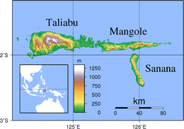
Mangole (Xulla Mangola - earlier name.[1]) is a large island in the Sula Islands, which again are part of Maluku Islands in Indonesia. It is located at 1°48′S 125°48′E / 1.8°S 125.8°E, east of Taliabu Island and north of Sanana Island. At the 2010 Census, 36,323 people lived on the island of Mangole. Its economy is dominated by the timber industry.
Notes
- ↑ Goodall, George (Editor)(1943) Philips' International Atlas London, George Philip and Son map 'East Indies' pp.91-92
- ^ Asia-Pacific Quake rocks Indonesian islands from BBC News, 30 November 1998
This article is issued from Wikipedia - version of the 11/17/2016. The text is available under the Creative Commons Attribution/Share Alike but additional terms may apply for the media files.