Mandaue
| Mandaue | ||
|---|---|---|
| Highly Urbanized City | ||
|
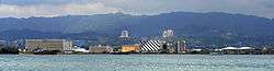
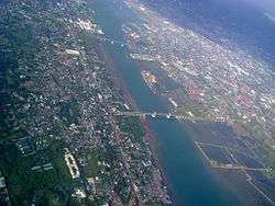
Mandaue from the sea | ||
| ||
|
Nickname(s): Furniture Capital of the Philippines Industrial Capital of Southern Philippines | ||
 Map of Central Visayas with Mandaue highlighted | ||
.svg.png) Mandaue Location within the Philippines | ||
| Coordinates: 10°20′N 123°56′E / 10.33°N 123.93°ECoordinates: 10°20′N 123°56′E / 10.33°N 123.93°E | ||
| Country | Philippines | |
| Region | Central Visayas (Region VII) | |
| Province | Central Visayas, Cebu | |
| District | 6th District of Cebu | |
| Settled Incorporated | 12th–16th century | |
|
1599 1899 30 August 1969 | |
| Barangay | 27 (see § Barangays) | |
| Government [1] | ||
| • Type | Sangguniang Panlungsod | |
| • Mayor | Luigi Quisumbing (LP) | |
| • Vice mayor | Carlo Fortuna | |
| • City Council |
Members
| |
| • Representative | Jonas Cortes | |
| Area[2] | ||
| • Total | 34.87 km2 (13.46 sq mi) | |
| Highest elevation | 100 m (300 ft) | |
| Population (2015 census)[3] | ||
| • Total | 362,654 | |
| • Density | 10,000/km2 (27,000/sq mi) | |
| • Voter (2016)[4] | 189,712 | |
| Time zone | PST (UTC+8) | |
| ZIP code | 6014 | |
| IDD : area code | +63 (0)32 | |
| Income class | 1st class | |
| PSGC | 072230000 | |
| Ecclesiastical province | Roman Catholic Archdiocese of Cebu | |
| Patron Saint | Joseph | |
| Diocesan Head | Adelito Abella | |
| Website |
www | |
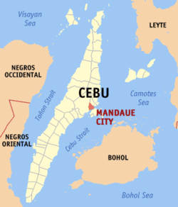
Mandaue, officially the City of Mandaue (Cebuano: Dakbayan sa Mandaue; Filipino: Lungsod ng Mandaue) and often referred to as Mandaue City, is a 1st city income class highly urbanized city in the region of Central Visayas (Region VII), Philippines. It is one of three highly urbanized cities on Cebu island and forms a part of the Cebu Metropolitan area.[5] Mandaue City is located on the central-eastern coastal region of Cebu; its southwest coast borders the northeast of Mactan Island, where Lapu-Lapu City is located. Mandaue is connected to Mactan Island via two bridges: the Mactan-Mandaue Bridge and Marcelo Fernan Bridge,[6] and is bounded south and the west by the provincial capital, Cebu City, and north by Consolacion, to which it is linked by the Cansaga Bay Bridge. The city has an area of 2,518 ha (6,220 acres). According to the 2015 census, it has a population of 362,654.[3] In the 2016 election, it had 189,712 registered voters.[4]
Mandaue City is part of the Sixth District of Cebu joined with the municipalities of Consolacion and Cordova. Although qualified for a lone district since 1991, this was neglected by lawmakers. Mandaue is an independent highly urbanized city but is legislatively administered with the supervision of the provincial government.
History
A community was established in Mandaue by a flourishing group of Austronesian people. The Venetian chronicler Antonio Pigafetta wrote of a settlement called Mandani which existed in the area with a chieftain named Apo Noan[7] then a few decades later another ruler named Lambuzzan.[8]
Mandaue natives were forced into a town as decreed by the Spanish authorities. This may have started off as a mission village (which included present day Consolacion, Liloan and Poro) serving as a bulwark for the church in the northern Cebu and was managed by the Jesuit in 1638 then a century later by the Recollects.[9]
The Philippine revolution in 1898 gave the town a new form of administration in accordance with the organic decree of the Central Revolutionary Government. The short-lived revolution was overthrown by the American Troops and a battle nearly destroyed the town in 1901, killing Presidente Benito Ceniza.[10]
Mandaue became independent from being an American Commonwealth and a Japanese garrison on July 4, 1946 along with the entire nation. Mandaue became a chartered city on June 21, 1969. The city was recognized as a HUC (Highly Urbanized City) in 1991.[11]
Geography
The city has a total area of 34.87 km2 (13.46 sq mi). According to the 2015 census, the population density is 10,000/km2 (26,000/sq mi).
|
| ||||||||||||||||||||||||||||||||||||||||

The city is the 6th smallest government unit in terms of land area; among the Metro Cebu local government units the city is the second smallest next to the municipality of Cordova in the island of Mactan. The city's land area is only 4.5% of the total land area of Metro Cebu and less than 1% of the total land of the province of Cebu.
The ongoing North Reclamation Project, now known as the North Special Administrative Zone, currently has about 180 ha (440 acres) reclaimed land. Of the 180 hectares, about 36 ha (89 acres) belong to the city. The existing mangrove area will be retained as a marine habitat, part of the area's parks and open spaces.
It is one of the two (the other one being the municipality of Consolacion) local government units located within the mainland Metro Cebu where the elevation of land is less than 100 m (330 ft).
Many of the areas of the city are extremely flat. About 77.37% is within the 0-8% slope category. Barangays belonging to this region are Centro, Looc, South Special Administrative Zone, Cambaro, Opao, Umapad, Paknaan, Alang-alang, Tipolo, Ibabao, Guizo, Subangdaku, Mantuyong, Maguikay and Tabok. The greater portion of the city, comprising about 70%, is dominated by the Mandaue Clay Loam soil series. This is found in the 0-2% and 2-5% slope ranges. Faraon clay loam characterizes the rest of the land with slope range from 5-8% and up to 25-40%.[12]
Barangays
Mandaue comprises 27 barangays.[2]
| PSGC | Barangay | Population | ±% p.a. | ||
|---|---|---|---|---|---|
| 2015[3] | 2010[13] | ||||
| 072230001 | Alang-alang | 3.7% | 13,457 | 12,475 | +1.45% |
| 072230002 | Bakilid | 1.3% | 4,591 | 5,027 | −1.71% |
| 072230003 | Banilad | 6.3% | 22,771 | 22,297 | +0.40% |
| 072230004 | Basak | 2.9% | 10,606 | 7,858 | +5.88% |
| 072230005 | Cabancalan | 3.9% | 14,132 | 12,202 | +2.84% |
| 072230006 | Cambaro | 2.6% | 9,474 | 8,082 | +3.07% |
| 072230007 | Canduman | 5.2% | 18,852 | 17,100 | +1.87% |
| 072230008 | Casili | 1.3% | 4,558 | 3,743 | +3.82% |
| 072230009 | Casuntingan | 4.1% | 14,690 | 13,217 | +2.03% |
| 072230010 | Centro (pob.) | 0.9% | 3,383 | 3,236 | +0.85% |
| 072230011 | Cubacub | 2.8% | 10,284 | 8,255 | +4.27% |
| 072230012 | Guizo | 2.7% | 9,623 | 8,554 | +2.27% |
| 072230013 | Ibabao-Estancia | 2.6% | 9,503 | 8,641 | +1.83% |
| 072230014 | Jagobiao | 3.8% | 13,685 | 12,227 | +2.17% |
| 072230015 | Labogon | 5.8% | 21,028 | 19,175 | +1.77% |
| 072230016 | Looc | 4.7% | 17,143 | 14,438 | +3.32% |
| 072230017 | Maguikay | 4.0% | 14,645 | 17,782 | −3.63% |
| 072230018 | Mantuyong | 1.8% | 6,540 | 5,869 | +2.08% |
| 072230019 | Opao | 3.2% | 11,457 | 9,907 | +2.81% |
| 072230020 | Pakna‑an | 7.4% | 26,943 | 22,957 | +3.10% |
| 072230021 | Pagsabungan | 5.6% | 20,335 | 16,838 | +3.66% |
| 072230022 | Subangdaku | 4.9% | 17,714 | 20,333 | −2.59% |
| 072230023 | Tabok | 5.0% | 18,167 | 15,709 | +2.81% |
| 072230024 | Tawason | 1.4% | 4,958 | 4,891 | +0.26% |
| 072230025 | Tingub | 1.9% | 6,774 | 5,780 | +3.07% |
| 072230026 | Tipolo | 5.2% | 18,840 | 17,273 | +1.67% |
| 072230027 | Umapad | 5.1% | 18,501 | 17,454 | +1.12% |
| Total | 362,654 | 44,732 | +48.95% | ||
Demographics
| Population census of Mandaue | |||||||||||||||||||||||||||||||
|---|---|---|---|---|---|---|---|---|---|---|---|---|---|---|---|---|---|---|---|---|---|---|---|---|---|---|---|---|---|---|---|
|
| ||||||||||||||||||||||||||||||
| Source: Philippine Statistics Office[3][13][14] | |||||||||||||||||||||||||||||||
Data showed that the oldest written accounts of Mandaue came from a population of 160 in 1637 to 1638. Mandaue had 10,309 souls according to the Buzeta & Bravo (1850). During the first year of its township in 1899, Mandaue had 42 barrios with a population of 21,086. When Mandaue was a second class municipality in 1964 its population was 33,811.[15]
According to the 2015 census, it has a population of 362,654, which is an increase of 102,926. Mandaue has a significantly large population at or below the poverty line.[16]
In the 2016 election, it had 189,712 registered voters, meaning that 52% of the population are aged 18 and over.[4]
Economy
About 40 percent of Cebu’s export companies are found in Mandaue. The city is dubbed as the industrial hub of Region VII and hosts about 10,000 industrial and commercial businesses, making it a “little rich city” in the country. It is home to some of the world’s biggest companies such as San Miguel Corp., Coca-cola Bottling Corp. and Shemberg, the number one exporter of carrageenan. Mandaue City also accounts for 75 percent of the country’s total exports in the furniture sector, making the city the furniture capital of the country.[17]
Cuisine
Mandaue has many restaurants which cater to gourmets and international cuisines like Italian, Japanese, Indian, Mediterranean, Lebanese, Arabic, Russian, Korean, Mexican, and Western cuisines. A variety of restaurants also serves meals of local cuisine.
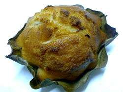
Many famous Cebuano meals like the lechon[18] or inasal, eaten with achara or pickled vegetables. The sugba or barbecue of either isda (fish), baboy (pork), manok (chicken) or baka (beef) is found all over Mandaue eaten with the puso a diamond-shaped hanged rice covered in coco leaves. Kinilaw[19] is raw meat usually pork or fish drenched in vinegar and salt. The buwad or dried seafood either fish or squid can be pungent with a crunchy and chewy texture. There are some exotic meals you can find like the dinugoan or pig's blood which is eaten like a soup. Barbecued chicken feet are liked by many locals. Original cuisine in Mandaue includes the bibingka which is steamed rice cakes mixed with coconut and sometimes egg. Binangos paired with rice is made of ground up corn with Bolinao fish. This dish is found only in Mandaue; other delicacies includes the tagaktak, the seasonal buriring fish (stewed with iba) and the famous masareal.
Transportation
Mandaue City's road network is composed of a national highway which connects the city to its neighboring cities and municipalities, and a national secondary road which traverses the city's metropolitan area. The total length of the city road network (paved and unpaved) and the four bridges, is about 133.7 km (83.1 mi), broken down into:
- National road - 13.2 km (8.2 mi)
- City road - 57.1 km (35.5 mi)
- Barangay road - 63.4 km (39.4 mi)
Road density is 5.31 km/km2 (8.55 mi/sq mi) of land. In terms of population, road density is 0.04 km (0.025 mi) per one thousand inhabitants.
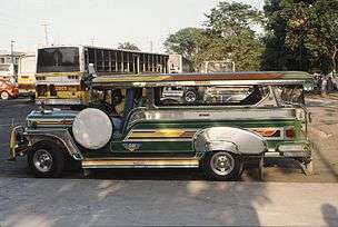
Land transportation is being served by PUJ, utility vehicles, mini-buses, multi-cabs, tricycles, trisikads and for cargoes, trailers and vans. Sea transport of Mandaue is highly dependent on Port of Cebu and Cebu International Port, because of the city's proximity to these facilities.
Education
Schools in Mandaue City follow a system of 6 years for primary education and 6 years for secondary education. There are technical schools like TESDA in Banilad and Looc and othe private institutions that provide certificate degrees. Associate degree, Baccalaureate Degrees, Master's and Doctoral programs are available in specific Universities.
Mandaue has institutionalized learning with the Cabahug Medal which was started on 1923 by Sotero Cabahug as a medal of academic excellence annually. The Mandaue Fraternal Society was also created in the early part of the 19th century to provide a community for the professionals during the time when Mandaue was still a sleepy town.
Cebu's part-time Japanese school, the Cebu Japanese School (CJS; セブ補習授業校 Sebu Hoshū Jugyō Kō), is located on the fifth floor of the Clotilde Commercial Center in Barangay Casuntingan, Mandaue City.[20]
Media
Television
Three television stations based in Mandaue City.
Sister cities
Local
- Bacolod and Dumaguete, Negros Island Region
- Baguio, Cordillera Administrative Region
- Butuan, Caraga Region
- Marikina, Metro Manila
International
References
- ↑ "City". Quezon City, Philippines: Department of the Interior and Local Government. Retrieved 30 May 2013.
- 1 2 "Municipal: Mandaue". PSGC Interactive. Quezon City, Philippines: Philippine Statistics Authority. Retrieved 8 January 2016.
- 1 2 3 4 "Region VII (CENTRAL VISAYAS)". Census of Population (2015): Total Population by Province, City, Municipality and Barangay (Report). PSA. Retrieved 20 June 2016.
- 1 2 3 "2016 National and Local Elections Statistics". Commission on Elections. 2016.
- ↑ "The brilliance of Mandaue City". Mandaue City. cebu-philippines.net.
- ↑ "Mandaue–Mactan Bridges I and II". Mandaue City. STS designs.
- ↑ To America and Around the World: The Logs of Christopher Columbus and of ... Antonio Pigafetta, Raleigh Ashlin Skelton. Branden Publishing Co.
- ↑ Magellan's voyage: a narrative of the first circumnavigation. Antonio Pigafetta/ Adolph Caso. Yale University.
- ↑ "Mandaue". admu.edu.ph. admu.edu.ph.
- ↑ Mojares 1999.
- ↑ "History". Mandaue City. Mandaue city government.
- ↑ "Land Use". Mandaue City. Mandaue city government.
- 1 2 "Region VII (CENTRAL VISAYAS)". Census of Population and Housing (2010): Total Population by Province, City, Municipality and Barangay (Report). NSO. Retrieved 29 June 2016.
- ↑ "Region VII (CENTRAL VISAYAS)". Census of Population (1995, 2000 and 2007): Total Population by Province, City and Municipality (Report). NSO. Archived from the original on 24 June 2011.
- ↑ "MANDAUE CITY: POPULATION TO REACH HALF A MILLION IN 2011". Census. Philippine Census.
- ↑ "Population". Mandaue City. Mandaue city government.
- ↑ http://www.unep.org/ietc/Portals/136/Other%20documents/Waste%20Management/Waste%20Plastic/WP_6_WasteQC_Mandaue.pdf
- ↑ "lechon". lechoncebu.com.
- ↑ "Sugba Tuwa Kilaw". Travelocity.com. Travelocity.com.
- ↑ Home page. Cebu Japanese School. Retrieved on April 2, 2015. "5th /F Clotilde Commercial CenterM.L. Quezon St., Casuntingan, Mandaue City 6014 Philippines"
- ↑ "Mandaue City officials fly to Romania for sister-city deal". The Manila Bulletin Newspaper Online. Manila Bulletin Publishing Corporation. Retrieved 2012-06-22.
- ↑ "Mandaue, Mosul sign sister-city agreement". Official Website of Mandaue City. The City of Mandaue. Retrieved 2012-06-21.
Sources
- Buzeta, Fr Manuel & Bravo, Fr Felipe, eds. (1850). Diccionario, geografico, estadistico, historico de las Islas Filipinas (2 vols) (in Spanish). Madrid.
- Cebu Daily News, Norman V. Mendoza (23 January 2015). "Rainbow lane in Mandaue". Archived from the original on 15 April 2015.
- Mojares, Resil B. (1999). The war against the Americans: resistance and collaboration in Cebu. Ateneo de Manila Press. ISBN 978-9715502986.
| Wikimedia Commons has media related to Mandaue. |
External links
![]() Mandaue travel guide from Wikivoyage
Mandaue travel guide from Wikivoyage
 |
Consolacion | | ||
| Cebu City | |
Camotes Sea | ||
| ||||
| | ||||
| Mactan Channel | Mactan Channel ⛴ Lapu‑Lapu |