Manalapan, Florida
| Manalapan, Florida | ||
|---|---|---|
| Town | ||
| Town of Manalapan | ||
| ||
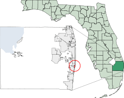 Location of Manalapan, Florida | ||
| Coordinates: 26°34′15″N 80°2′40″W / 26.57083°N 80.04444°WCoordinates: 26°34′15″N 80°2′40″W / 26.57083°N 80.04444°W | ||
| Country |
| |
| State |
| |
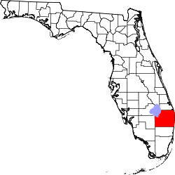
| County |
| |
| Area | ||
| • Total | 2.4 sq mi (6.3 km2) | |
| • Land | 0.5 sq mi (1.2 km2) | |
| • Water | 2.0 sq mi (5.1 km2) | |
| Elevation | 3 ft (1 m) | |
| Population (2000) | ||
| • Total | 321 | |
| • Density | 712.7/sq mi (275.2/km2) | |
| Time zone | Eastern (EST) (UTC-5) | |
| • Summer (DST) | EDT (UTC-4) | |
| ZIP code | 33462 | |
| Area code(s) | 561 | |
| FIPS code | 12-42700[1] | |
| GNIS feature ID | 0286344[2] | |
Manalapan is a town in Palm Beach County, Florida. The population was 321 at the 2000 United States Census.
History
United States President Benjamin Harrison granted George H. K. Carter a homestead in 1889 on the yet unnamed land.[3] In 1931, the sparsely populated settlement was incorporated by Harold Stirling Vanderbilt as the “Town of Manalapan”.[3] A large share of the first settlers being natives of Manalapan, New Jersey caused the name to be selected.[4]
One of the most puzzling mysteries in Florida history was the disappearance of Circuit Judge Curtis Chillingworth who left a friend's home on the night of 14 June 1955, and went to their ocean-front cottage in Manalapan.[5]
The U.S. presidential yacht Sequoia was auctioned at the La Coquille Club in Manalapan on 25 March 1977 during the Carter administration, for US$270,000, as a symbolic cutback in Federal Government spending (annual cost to the U.S. Navy was $800,000) and to reduce signs of an "imperial presidency".[6]
The popular tourist restaurant John G's moved to Manalapan in 2011 from its location in Lake Worth where it had been for 30+ years.
Geography
Manalapan is located at 26°33′52″N 80°02′36″W / 26.564397°N 80.043359°W.[7]
Manalapan is a small beach side community. It is bordered on the north by the bridge, beach access road and beach for the Town of Lantana, Florida; on the west by the intracoastal waterway (known locally as Lake Worth Lagoon); on the south by the South Lake Worth Inlet (known locally as "Boynton Inlet"); and on the east by the Atlantic Ocean.
According to the United States Census Bureau, the town has a total area of 2.4 square miles (6.2 km2), of which 0.4 square miles (1.0 km2) is land and 2.0 square miles (5.2 km2) (81.48%) is water.
Demographics
| Historical population | |||
|---|---|---|---|
| Census | Pop. | %± | |
| 1940 | 40 | — | |
| 1950 | 54 | 35.0% | |
| 1960 | 62 | 14.8% | |
| 1970 | 205 | 230.6% | |
| 1980 | 329 | 60.5% | |
| 1990 | 312 | −5.2% | |
| 2000 | 321 | 2.9% | |
| 2010 | 406 | 26.5% | |
| Est. 2015 | 449 | [8] | 10.6% |
As of the census[1] of 2000, there were 321 people, 167 households, and 107 families residing in the town. The population density was 712.7 inhabitants per square mile (275.4/km²). There were 271 housing units at an average density of 601.7 per square mile (232.5/km²). The racial makeup of the town was 98.13% White (95% were Non-Hispanic White,)[10] 1.56% Asian and 0.31% Pacific Islander. Hispanic or Latino of any race were 3.12% of the population.
There were 167 households out of which 9.6% had children under the age of 18 living with them, 59.9% were married couples living together, 2.4% had a female householder with no husband present, and 35.9% were non-families. 30.5% of all households were made up of individuals and 21.0% had someone living alone who was 65 years of age or older. The average household size was 1.92 and the average family size was 2.33.
In the town the population was spread out with 7.8% under the age of 18, 2.2% from 18 to 24, 13.4% from 25 to 44, 35.8% from 45 to 64, and 40.8% who were 65 years of age or older. The median age was 61 years. For every 100 females there were 94.5 males. For every 100 females age 18 and over, there were 91.0 males.
The median income for a household in the town was $127,819, and the median income for a family was $117,051. Males had a median income of over $100,000 versus $36,250 for females. The per capita income for the town was $143,729. About 3.7% of families and 5.9% of the population were below the poverty line, including none of those under age 18 and 4.3% of those age 65 or over.
As of 2000, speakers of English as a first language accounted for 98.54%, while French as a mother tongue accounted for 1.45% of the population.[11] As of 2004, the population recorded by the U.S. Census Bureau was 340.[12]
Trivia
- A portion of the 1981 movie, Body Heat, starring William Hurt and Kathleen Turner, was filmed in Manalapan.[13]
Notable people
- F. Lee Bailey, famed criminal defense lawyer
- Don King (boxing promoter)
- Thomas "Loel" Guinness and Gloria Guinness
- Charles Peter McColough, former Xerox Chairman and CEO, and family had an oceanfront estate in Manalapan for nearly 50 years.
- Generoso Pope Jr., founded National Enquirer, and wife.
- Lois Pope, philanthropist/widow of National Enquirer founder
- Yanni, musician, lives in oceanfront home
- Hal Prewitt, past Town Commissioner, Artist, Photographer, Race car driver, inventor of personal computer products and early pioneer in the personal computer revolution[14]
- Geoff Brabham, Race Car Driver - IMSA GTP Champion
- Curtis Chillingworth - Circuit Judge, Palm Beach, Florida
References
- 1 2 "American FactFinder". United States Census Bureau. Retrieved 2008-01-31.
- ↑ "US Board on Geographic Names". United States Geological Survey. 2007-10-25. Retrieved 2008-01-31.
- 1 2 "Town of Manalapan History". Town of Manalapan. Retrieved 2010-06-09.
- ↑ Kleinberg, Eliot (Sep 16, 1987). "A Town By Any Other Name". The Palm Beach Post. pp. D7. Retrieved 30 May 2015.
- ↑ McIver, Stuart B. (2008). Murder in the Tropics: The Florida Chronicles, Volume 2. Pineapple Press. ISBN 978-1-56164-441-4.
- ↑ Congressional Record - House - 108th Congress, 150, Government Printing Office, 2004-11-20, p. 25146, retrieved 2010-06-09
- ↑ "US Gazetteer files: 2010, 2000, and 1990". United States Census Bureau. 2011-02-12. Retrieved 2011-04-23.
- ↑ "Annual Estimates of the Resident Population for Incorporated Places: April 1, 2010 to July 1, 2015". Retrieved July 2, 2016.
- ↑ "Census of Population and Housing". Census.gov. Retrieved June 4, 2015.
- ↑ "Demographics of Manalapan, FL". MuniNetGuide.com. Retrieved 2007-11-23.
- ↑ "MLA Data Center Results for Manalapan, Florida". Modern Language Association. Retrieved 2007-11-23.
- ↑ http://www.census.gov/popest/cities/tables/SUB-EST2004-04-12.xls
- ↑ "Filming locations for Body Heat". Retrieved 8 Feb 2010.
- ↑ "Hal Prewitt; a computer whiz kid challenges the big boys". Florida Trend. August 1, 1987. Retrieved January 31, 2010.