Malverne Park Oaks, New York
| Malverne Park Oaks, New York | |
|---|---|
| Census-designated place | |
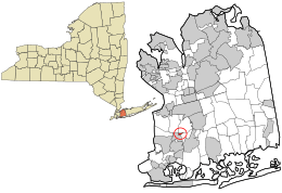 Location in Nassau County and the state of New York. | |
 Location within the state of New York | |
| Coordinates: 40°40′52″N 73°39′53″W / 40.68111°N 73.66472°WCoordinates: 40°40′52″N 73°39′53″W / 40.68111°N 73.66472°W | |
| Country | United States |
| State | New York |
| County | Nassau |
| Area | |
| • Total | 0.1 sq mi (0.3 km2) |
| • Land | 0.1 sq mi (0.3 km2) |
| • Water | 0.0 sq mi (0.0 km2) |
| Elevation | 10 ft (3 m) |
| Population (2010) | |
| • Total | 505 |
| Time zone | Eastern (EST) (UTC-5) |
| • Summer (DST) | EDT (UTC-4) |
| FIPS code | 36-44792 |
| GNIS feature ID | 1852905 |
Malverne Park Oaks is a census-designated place (CDP) in Nassau County, New York, in the United States. As of the 2010 census, the CDP population was 505. The CDP was first created for the 2000 census.[1]
History and background
While designated as one area, it is actually made up of three different smaller communities - Malverne Park, Malverne Oaks South, and Malverne Oaks North.
When the Village of Malverne was seeking to become an incorporated village in 1920, the residents from this area did not wish to become part of the new village and therefore remained a hamlet under the Town of Hempstead.
Malverne Park is more closely associated with Malverne proper as it falls within its fire and school districts as well as the Malverne ZIP code (11565).
Malverne Oaks North and South are linked more with West Hempstead for similar districting reasons and West Hempstead ZIP code (11552). The North & South communities are separated by the Southern State Parkway.
Geography

Malverne Park Oaks is located at 40°40′52″N 73°39′53″W / 40.68111°N 73.66472°W (40.681018, -73.664835).[2]
According to the United States Census Bureau, the CDP has a total area of 0.1 square miles (0.26 km2), all land.
Demographics
As of the census[3] of 2000, there were 470 people, 175 households, and 145 families residing in the CDP. The population density was 4,002.1 per square mile (1,512.2/km²). There were 175 housing units at an average density of 1,490.1/sq mi (563.1/km²). The racial makeup of the CDP was 90.64% White, 3.62% African American, 4.26% Asian, 1.28% from other races, and 0.21% from two or more races. Hispanic or Latino of any race were 7.45% of the population.
There were 175 households out of which 34.3% had children under the age of 18 living with them, 72.0% were married couples living together, 8.0% had a female householder with no husband present, and 16.6% were non-families. 13.7% of all households were made up of individuals and 8.6% had someone living alone who was 65 years of age or older. The average household size was 2.69 and the average family size was 2.94.
In the CDP the population was spread out with 22.8% under the age of 18, 4.5% from 18 to 24, 23.4% from 25 to 44, 30.2% from 45 to 64, and 19.1% who were 65 years of age or older. The median age was 45 years. For every 100 females there were 92.6 males. For every 100 females age 18 and over, there were 87.1 males.
The median income for a household in the CDP was $91,208, and the median income for a family was $91,597. Males had a median income of $56,786 versus $31,250 for females. The per capita income for the CDP was $34,379. None of the population or families were below the poverty line.
References
- ↑ "New York: 2000 Population and Housing Unit Counts" (PDF). September 2003. p. III-9. Retrieved 2010-12-22.
- ↑ "US Gazetteer files: 2010, 2000, and 1990". United States Census Bureau. 2011-02-12. Retrieved 2011-04-23.
- ↑ "American FactFinder". United States Census Bureau. Retrieved 2008-01-31.