Malvern, Victoria
| Malvern Melbourne, Victoria | |||||||||||||
|---|---|---|---|---|---|---|---|---|---|---|---|---|---|
 Malvern Town Hall | |||||||||||||
 Malvern | |||||||||||||
| Coordinates | 37°51′25″S 145°02′10″E / 37.857°S 145.036°ECoordinates: 37°51′25″S 145°02′10″E / 37.857°S 145.036°E | ||||||||||||
| Population | 9,504 (2011 census)[1] | ||||||||||||
| • Density | 3,280/km2 (8,490/sq mi) | ||||||||||||
| Established | 1835 | ||||||||||||
| Postcode(s) | 3144 | ||||||||||||
| Area | 2.9 km2 (1.1 sq mi) | ||||||||||||
| Location | 8 km (5 mi) from Melbourne | ||||||||||||
| LGA(s) | City of Stonnington | ||||||||||||
| State electorate(s) | Malvern | ||||||||||||
| Federal Division(s) | Higgins | ||||||||||||
| |||||||||||||
Malvern (/ˈmɔːlvən/) is a suburb of Melbourne, Australia, 8 km south-east of Melbourne's Central Business District. Its local government area is the City of Stonnington. At the 2011 Census, Malvern had a population of 9,504.
History
The area of Malvern was first settled in 1835.
John Gardiner was one of its first settlers.[2] A small hamlet known as "Gardiners Creek" (1851 Melbourne Postal Directory) was settled, but it diminished with the gold rush. The nearby creek was also named Gardiners Creek. Gardiners Creek Road (now Toorak Road) ran from South Yarra, east to the junction of Gardiners Creek and onto the Gardiner Homestead, which is now the site of Scotch College.
In the 1860s the Gardiners Creek Roads Board was the forerunner of the Gardiners Creek Shire that then became Malvern Council.
Malvern Post Office opened on 1 January 1860 on Glenferrie Road, near Malvern Road. In 1892 this was renamed Malvern North, when a new Malvern office on Glenferrie Road, near Wattletree Road, replaced the Malvern Railway Station office.[3]
The then shire hall (later town hall) was built in 1886, on the corner of Glenferrie Road and High Street and later extended.
Prahran and Malvern Tramways Trust ran their first car out of Malvern depot on 30 May 1910.
Malvern is the original home of Malvern Star, once Australia's largest and most well-known bicycle manufacturer.[4]
Attractions
Its main shopping attractions are Malvern Central, home to high-end department store David Jones and Glenferrie Road, housing a wide variety of restaurants, shops and boutiques.
There are several beautiful Victorian parks and gardens in Malvern, including Malvern Gardens, in Spring Road.
The Stonnington City Centre (formerly Malvern Town Hall), in Second Empire style, is now the corporate headquarters for the City of Stonnington.
Significant heritage buildings listed on the Victorian Heritage Register include Stonington mansion (1890), Malvern tram depot, the former ES&A Bank (on the corner of Glenferrie Road and High Street) and the Malvern railway station.
Other significant buildings include St Joseph's Parish Church (Roman Catholic) and De La Salle College tower building. There is also an Anglican Parish Church dedicated to St George and a Presbyterian Church.
Transport
The Malvern tram depot, located on Glenferrie Road, provides trams for the various routes which service Malvern.
Malvern Station is a busy station, on the Frankston, Pakenham and Cranbourne lines. In addition, Tooronga Station also services the northern section of the suburb, on the Glen Waverley line.
Schools
- De La Salle College, Malvern
- Malvern Primary School, Tooronga Road
- St Joseph's Primary School
- Malvern Central School, Spring Road
Notable citizens
- Rupert Betheras – Former AFL Collingwood footballer, grew up in East Malvern and attended Lloyd Street Central School and De La Salle College.
- Andrew Bolt – Political commentator
- Andrea Bresciani – Italian-born cartoonist and animator lived in Malvern in his later years and died there in 2006.[5]
- Katya Crema – Double Winter Olympian competing in Skier Cross.
- John Mark Davies – President of the Victorian Legislative Council from 1910–1919 and original owner of Malvern House (Valentines).
- Jason Donovan – Was born in Malvern.
- Robert Doyle – The 103rd Lord Mayor of Melbourne, the former Member for Malvern and former Leader of the Opposition in the Victorian Legislative Assembly.
- Jack Dyer – Captain of Richmond Football Club, attended De La Salle College
- Colin Egar – Australian Test cricket match umpire, was born in Malvern in 1928.
- Tom Hafey – Australian rules (VFL) Football Champion player and coach, Tommy 'T-shirt' Hafey attended Lloyd Street Central School (now Lloyd Street Primary) in East Malvern.
- Harold Holt – Politician and the 17th Prime Minister of Australia from 1966 – 1967 and is commemorated by the Harold Holt Memorial Swimming Centre, a swimming pool complex in neighbouring Glen Iris.
- Gertrude Johnson – Soprano and founder of the National Theatre, died in Malvern in 1973.
- John Landy – Former track athlete and the 26th Governor of Victoria. Attended school at Malvern Memorial Grammar School.
- Stephanie McIntosh – Actor and singer.
- Sir Robert Menzies – Prime Minister of Australia lived in Haverbrack Avenue, Malvern and has been commemorated in the naming of the Robert Menzies Reserve, bounded by Elizabeth Street, Henderson Avenue and Toorak Road in Malvern.
- Hubert Opperman – Australian cyclist and politician, who was once employed by Malvern Star Cycles, a tiny cycle shop in Malvern.
- Bruce Small – Successful businessman, who developed Malvern Star bicycles into a household name in Australia.
- Jesse Spencer – Hollywood Actor, late of Neighbours, now of 'House' fame, attended Malvern Central School in the 1980s.
- Lindsay Thompson – Politician, who was Premier of the state of Victoria from 1981 to 1982 and the Member for Malvern.
Gallery
 Stonington mansion after which the City of Stonnington was named.
 The Valentine's Mansion (now Caulfield Grammar School - Malvern Campus).
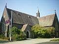 St George's Anglican Parish Church
 St Joseph's RC Parish Church
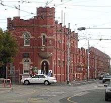 Malvern tram depot
- Stonnington City Centre
 Sculptures in the City Square
See also
- City of Malvern – the former local government area
References
- ↑ Australian Bureau of Statistics (31 October 2012). "Malvern (State Suburb)". 2011 Census QuickStats. Retrieved 17 July 2012.
- ↑ Leslie J. Wilmoth, 'Gardiner, John (1798–1878)', Australian Dictionary of Biography, Volume 1, MUP, 1966, p. 425.
- ↑ Premier Postal History, Post Office List, retrieved 11 April 2008
- ↑ Canberra Bicycle Museum http://canberrabicyclemuseum.com.au/MalvernStar/
- ↑ AustLit. "Bresciani, Andrea". Retrieved 13 September 2016 (subscription required for full access).
- John Butler Cooper, The History of Malvern
- 150th Anniversary of Gardiner Road Board (later Malvern Council)
- Stonnington Heritage Markers
- About Stonnington – How a city was formed