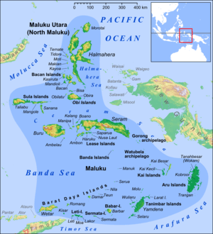
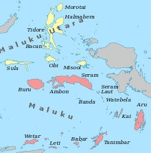
Maluku Islands
 | |
| Geography | |
|---|---|
| Location | South East Asia, also Oceania (physical geography) |
| Coordinates | 3°9′S 129°23′E / 3.150°S 129.383°E |
| Total islands | ~1000 |
| Major islands | Halmahera, Seram, Buru, Ambon, Ternate, Tidore, Aru Islands, Kai Islands |
| Area | 74,505 km2 (28,767 sq mi) |
| Highest elevation | 3,027 m (9,931 ft) |
| Highest point | Binaiya |
| Administration | |
|
Indonesia | |
| Provinces | Maluku, North Maluku |
| Largest settlement | Ambon |
| Demographics | |
| Population | 1,895,000 (2000) |
| Ethnic groups | Alfur, Nuaulu, European, Middle Eastern (Mainly Arabian and Jewish), Melanesian, Bugis |
The Maluku Islands or the Moluccas (/məˈlʌkəz/) are an archipelago within Indonesia. Tectonically they are located on the Halmahera Plate within the Molucca Sea Collision Zone. Geographically they are located east of Sulawesi, west of New Guinea, and north and east of Timor. The islands were also the historical core of the Spice Islands known to the Chinese and Europeans, but this term usually included other adjacent areas such as Sulawesi.
They have been known as the Spice Islands due to the nutmeg, mace and cloves that were originally found only there, and the presence of these sparked colonial interest from Europe in the 16th century.[1]
Though originally Melanesian,[2] many island populations, especially in the Banda Islands, were exterminated in the 17th century during the spice wars. A second influx of Austronesian immigrants began in the early twentieth century under the Dutch and continues in the Indonesian era.
The Maluku Islands formed a single province from Indonesian independence until 1999, when it was split into two provinces. A new province, North Maluku, incorporates the area between Morotai and Sula, with the arc of islands from Buru and Seram to Wetar remaining within the existing Maluku Province. North Maluku is predominantly Muslim, and its capital is Sofifi on Halmahera island. Maluku province has a larger Christian population, and its capital is Ambon.
Between 1999 and 2002, conflict between Muslims and Christians killed thousands and displaced half a million people.
Etymology
The name Maluku is thought to have been derived from the term used by Arab traders for the region, Jazirat al-Muluk ("the island of the kings").[3]
Administrative divisions
The Maluku Islands were a single province from Indonesian independence until 1999 when they were split into North Maluku and Maluku.
North Maluku province includes Ternate (the former site of the provincial capital), Tidore, Bacan, Halmahera (the largest of the Maluku Islands)[4] Morotai, the Obi Islands, and the Sula Islands. The residual Maluku province includes Ambon (the site of the provincial capital) and the other Lease Islands; the much larger islands of Seram and Buru; the smaller islands lying south and east of Seram—the Banda Islands, Gorong Islands, Watubela Islands, Kai Islands and Aru Islands; and in the far south the Babar Islands, Damar Islands, Romang, Kisar, the Leti Islands, Tanimbar Islands, and Wetar.
History

Early history
The earliest archaeological evidence of human occupation of the region is about thirty-two thousand years old, but evidence of even older settlements in Australia may mean that Maluku had earlier visitors. Evidence of increasingly long-distance trading relationships and of more frequent occupation of many islands, begins about ten to fifteen thousand years later. Onyx beads and segments of silver plate used as currency on the Indian subcontinent around 200BC have been unearthed on some of the islands. In addition, local dialects employ derivations of the Malay word then in use for 'silver', in contrast to the term used in wider Melanesian society, which has etymological roots in Chinese, a consequence of the regional trade with China that was developed in the 6th and 7th centuries.
Arab merchants began to arrive in the 14th century, bringing Islam. Peaceful conversion to Islam occurred in many islands, especially in the centres of trade, while aboriginal animism persisted in the hinterlands and more isolated islands. Archaeological evidence here relies largely on the occurrence of pigs' teeth, as evidence of pork eating or abstinence therefrom.[5]
Portuguese
The most significant lasting effects of the Portuguese presence was the disruption and reorganization of the Southeast Asian trade, and in eastern Indonesia—including Maluku—the introduction of Christianity.[6] The Portuguese had conquered the city state of Malacca in the early 16th century and their influence was most strongly felt in Maluku and other parts of eastern Indonesia.[3] After the Portuguese annexed Malacca in August 1511, one Portuguese diary noted 'it is thirty years since they became Moors'[7]- giving a sense of the competition then taking place between Islamic and European influences in the region.
Afonso de Albuquerque learned of the route to the Banda Islands and other 'Spice Islands', and sent an exploratory expedition of three vessels under the command of António de Abreu, Simão Afonso Bisigudo and Francisco Serrão.[8] On the return trip, Francisco Serrão was shipwrecked at Hitu island (northern Ambon) in 1512. There he established ties with the local ruler who was impressed with his martial skills. The rulers of the competing island states of Ternate and Tidore also sought Portuguese assistance and the newcomers were welcomed in the area as buyers of supplies and spices during a lull in the regional trade due to the temporary disruption of Javanese and Malay sailings to the area following the 1511 conflict in Malacca. The spice trade soon revived but the Portuguese would not be able to fully monopolize nor disrupt this trade.[3]
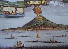
Allying himself with Ternate's ruler, Serrão constructed a fortress on that tiny island and served as the head of a mercenary band of Portuguese seamen under the service of one of the two local feuding sultans who controlled most of the spice trade. Both Serrão and Ferdinand Magellan, however, perished before they could meet one another.[3]
The Portuguese first landed in Ambon in 1513, but it only became the new centre for their activities in Maluku following the expulsion from Ternate. European power in the region was weak and Ternate became an expanding, fiercely Islamic and anti-European state under the rule of Sultan Baab Ullah (r. 1570–1583) and his son Sultan Said.[9]
Following Portuguese missionary work, there have been large Christian communities in eastern Indonesia through to contemporary times, which has contributed to a sense of shared interest with Europeans, particularly among the Ambonese.[9] By the 1560s there were 10,000 Catholics in the area, mostly on Ambon, and by the 1590s there were 50,000 to 60,000. The central and southern parts of Maluku are populated majority by Christians, living in harmony with their Muslim brothers and sisters due to the "Pela Gandong" communal relationship system established by their ancestors more than 400 years ago. The "Pela Gandong" community relationship system is between various Christian and Muslim villages throughout the regions.
Dutch
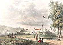
The Dutch arrived in 1599 and competed with the Portuguese in the area for trade. The Dutch East India Company was a mercantile corporation that gradually gained complete control of the islands, leaving smuggling as the only native alternative to the Dutch monopoly.

After Indonesian independence
With the declaration of a single republic of Indonesia in 1950 to replace the federal state, a Republic of South Maluku (Republik Maluku Selatan, RMS) was declared and attempted to secede. The RMS was centred around Seram, Ambon, and Buru and led by Chris Soumokil (former Supreme Prosecutor of the Eastern Indonesia state) and supported by the Moluccan members of the Netherlands special troops. This movement was defeated by the Indonesian army and by special agreement with the Netherlands the troops were transferred to the Netherlands. The commencement of Indonesian transmigration of (mainly Javanese) populations to the outer islands (including Maluku) during the 1960s is thought to have aggravated independence and issues of religious / ethnic politics. There has been occasional ethnic and nationalist violence on the islands.
Maluku is one of the first provinces of Indonesia, proclaimed in 1945 until 1999, when the Maluku Utara and Halmahera Tengah Regencies were split off as a separate province of North Maluku. Its capital is Ternate, on a small island to the west of the large island of Halmahera. The capital of the remaining part of Maluku province remains at Ambon.
1999–2003 inter-communal conflict
Religious conflict erupted across the islands in January 1999. The subsequent 18 months were characterized by fighting between largely local groups of Muslims and Christians, the destruction of thousands of houses, the displacement of approximately 500,000 people, the loss of thousands of lives, and the segregation of Muslims and Christians.[10]
Geology and geography
The Maluku Islands have a total area of 850,000 km2, 90% of which is sea.[11] There are an estimated 1027 islands.[12] The largest two islands, Halmahera and Seram are sparsely populated, while the most developed, Ambon and Ternate are small.[12]
The majority of the islands are forested and mountainous. The Tanimbar Islands are dry and hilly, while the Aru Islands are flat and swampy. Mount Binaya (3027 m) on Seram is the highest mountain. A number of islands, such as Ternate (1721 m) and the TNS islands, are volcanoes emerging from the sea with villages sited around their coasts. There have been over 70 serious volcanic eruptions in the last 500 years and earthquakes are common.[12]

The geology of the Maluku Islands share much similar history, characteristics and processes with the neighbouring Nusa Tenggara region. There is a long history of geological study of these regions since Indonesian colonial times; however, the geological formation and progression is not fully understood, and theories of the island's geological evolution have changed extensively in recent decades.[13] The Maluku Islands comprise some of the most geologically complex and active regions in the world,[14] resulting from its position at the meeting point of four geological plates and two continental blocks.
Biota and environment
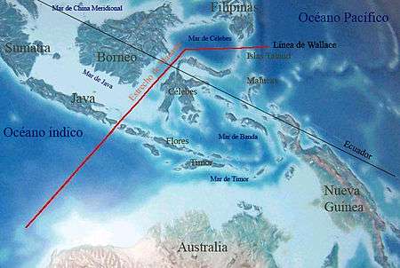
Biogeographically, all of the islands apart from the Aru group lie in Wallacea, the region between the Sunda Shelf (part of the Asia block), and the Arafura Shelf (part of the Australian block). More specifically, they lie between Weber's Line and Lydekker's Line, and thus have a fauna that is rather more Australasian than Asian. Malukan biodiversity and its distribution are affected by various tectonic activities; most of the islands are geologically young, being from 1 million to 15 million years old, and have never been attached to the larger landmasses. The Maluku islands differ from other areas in Indonesia; they contain some of the country's smallest islands, coral island reefs scattered through some of the deepest seas in the world, and no large islands such as Java or Sumatra. Flora and fauna immigration between islands is thus restricted, leading to a high rate of endemic biota evolving.[13]
The ecology of the Maluku Islands has fascinated naturalists for centuries; Alfred Wallace's book, The Malay Archipelago was the first significant study of the area's natural history, and remains an important resource for studying Indonesian biodiversity. Maluku is the subject of two major historical works of natural history by Georg Eberhard Rumphius: the Herbarium Amboinense and the Amboinsche Rariteitkamer.[15]
Rainforest covered most of northern and central Maluku, which, on the smaller islands has been replaced by plantations, including the region's endemic cloves and nutmeg. The Tanimbar Islands and other southeastern islands are arid and sparsely vegetated, much like nearby Timor.[12] In 1997 the Manusela National Park, and in 2004 the Aketajawe-Lolobata National Park have been established, for the protection of endangered species.
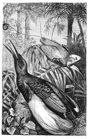
Nocturnal marsupials, such as cuscus and bandicoots, make up the majority of the mammal species, and introduced mammals include Malayan civets and wild pigs.[12] Bird species include approximately 100 endemics with the greatest variety on the large islands of Halmahera and Seram. North Maluku has two species of endemic birds of paradise.[12] Uniquely among the Maluku Islands, the Aru Islands have a purely Papuan fauna including kangaroos, cassowaries, and birds of paradise.[12]
While many ecological problems affect both small islands and large landmasses, small islands suffer their particular problems. Development pressures on small islands are increasing, although their effects are not always anticipated. Although Indonesia is richly endowed with natural resources, the resources of the small islands of Maluku are limited and specialised; furthermore, human resources in particular are limited.[16]
General observations[17] about small islands that can be applied to the Maluku Islands include:[16]
- a higher proportion of the landmass will be affected by volcanic activity, earthquakes, landslips, and cyclone damage;
- Climates are more likely to be maritime influenced;
- Catchment areas are smaller and degree of erosion higher;
- A higher proportion of the landmass is made up of coastal areas;
- A higher degree of environmental specialisation, including a higher proportion of endemic species in an overall depauperate community;
- Societies may retain a strong sense of culture having developed in relative isolation;
- Small island populations are more likely to be affected by economic migration.
Climate
Central and southern Maluku Islands experience the dry monsoon between October to March and the wet monsoon from May to August, which is the reverse of the rest of Indonesia. The dry monsoon's average maximum temperature is 30 °C while the wet's average maximum is 23 °C. Northern Maluku has its wet monsoon from December to March in line with the rest of Indonesia. Each island group have their own climatic variations, and the larger islands tend to have drier coastal lowlands and their mountainous hinterlands are wetter.[12]
Demographics
.jpg)
Maluku's population is about 2 million, less than 1% of Indonesia's population.[12]
Over 130 languages were once spoken across the islands; however many have now mixed to form local pidgin dialects of Ternatean and Ambonese, the lingua franca of northern and southern Maluku respectively.[12]
A long history of trade and seafaring has resulted in a high degree of mixed ancestry in Malukans.[12] Austronesian peoples added to the native Melanesian population around 2000 BCE.[18] Melanesian features are strongest in the islands of Kei and Aru and amongst the interior people of Seram and Buru islands. Later added to this Austronesian-Melanesian mix were Indian, Arab, Chinese, Portuguese and Dutch descent. More recent arrivals include Bugis trader settlers from Sulawesi and Javanese transmigrants.[12]
Economy
Cloves and nutmeg are still cultivated, as are cocoa, coffee and fruit. Fishing is a big industry across the islands but particularly around Halmahera and Bacan. The Aru Islands produce pearls, and Seram exports lobsters. Logging is a significant industry on the larger islands with Seram producing ironwood and teak and ebony are produced on Buru.[12]
See also
References
Notes
- ↑ "Introducing Maluku". Lonely Planet. Retrieved 18 April 2015.
- ↑ IRJA.org Archived 14 April 2009 at the Wayback Machine.
- 1 2 3 4 Ricklefs, M.C. (1991). A History of Modern Indonesia Since c.1300, 2nd Edition. London: MacMillan. p. 24. ISBN 0-333-57689-6.
- ↑ Monk, K.A.; Fretes, Y.; Reksodiharjo-Lilley, G. (1996). The Ecology of Nusa Tenggara and Maluku. Hong Kong: Periplus Editions Ltd. p. 7. ISBN 962-593-076-0.
- ↑ Lape, PV. (2000). Contact and Colonialism in the Banda Islands, Maluku, Indonesia; Indo-Pacific Prehistory Association Bulletin 20 (Melaka Papers, Vol.4); http://ejournal.anu.edu.au/index.php/bippa/article/viewFile/237/227, p. 2 - 3
- ↑ Ricklefs, M.C. (1991). A History of Modern Indonesia Since c.1300, 2nd Edition. London: MacMillan. p. 26. ISBN 0-333-57689-6.
- ↑ Lach, DF. (1994) Asia in the Making of Europe: The Century of Discovery (Vol 1), Chicago University Press
- ↑ E. C. Abendanon and E. Heawood (December 1919). "Missing Links in the Development of the Ancient Portuguese Cartography of the Netherlands East Indian Archipelago". The Geographical Journal. Blackwell Publishing. 54 (6): 347–355. doi:10.2307/1779411. JSTOR 1779411.
- 1 2 Ricklefs, M. C. (1991). A History of Modern Indonesia Since c.1300, 2nd Edition. London: MacMillan. p. 25. ISBN 0-333-57689-6.
- ↑ "Troubled history of the Moluccas". BBC News. 26 June 2000. Retrieved 2007-05-17.
- ↑ Monk, K.A.; Fretes, Y.; Reksodiharjo-Lilley, G. (1996). The Ecology of Nusa Tenggara and Maluku. Hong Kong: Periplus Editions Ltd. p. 9. ISBN 962-593-076-0.
- 1 2 3 4 5 6 7 8 9 10 11 12 13 Witton, Patrick (2003). Indonesia. Melbourne: Lonely Planet. p. 818. ISBN 1-74059-154-2.
- 1 2 Monk (1996), page 9
- ↑ Monk,, K.A.; Fretes, Y.; Reksodiharjo-Lilley, G. (1996). The Ecology of Nusa Tenggara and Maluku. Hong Kong: Periplus Editions Ltd. p. 9. ISBN 962-593-076-0.
- ↑ Monk,, K.A.; Fretes, Y.; Reksodiharjo-Lilley, G. (1996). The Ecology of Nusa Tenggara and Maluku. Hong Kong: Periplus Editions Ltd. p. 4. ISBN 962-593-076-0.
- 1 2 Monk,, K.A.; Fretes, Y.; Reksodiharjo-Lilley, G. (1996). The Ecology of Nusa Tenggara and Maluku. Hong Kong: Periplus Editions Ltd. p. 1. ISBN 962-593-076-0.
- ↑ Beller, W., P. d'Ayala, and P. Hein. 1990. Sustainable development and environmental management of small islands. Paris and New Jersey: United Nations Educational, Scientific, and Cultural Organisation and Parthenon Publishing Group Inc.; Hess, A, 1990. Overview: sustainable development and environmental management of small islands. In Sustainable development and environmental management of small islands. eds W. Beller, P. d'Ayala, and P. Hein, Paris and New Jersey: United Nations Educational, Scientific, and Cultural Organisation and Parthenon Publishing Group Inc. (both cited in Monk)
- ↑ Taylor, Jean Gelman (2003). Indonesia: Peoples and Histories. New Haven and London: Yale University Press. pp. 5–7. ISBN 0-300-10518-5.
General
- Andaya, Leonard Y. (1993). The World of Maluku: Eastern Indonesia in the Early Modern Period. Honolulu: University of Hawai'i Press. ISBN 0-8248-1490-8.
- Bellwood, Peter (1997). Prehistory of the Indo-Malaysian archipelago. Honolulu: University of Hawai'i Press. ISBN 0-8248-1883-0.
- Donkin, R. A. (1997). Between East and West: The Moluccas and the Traffic in Spices Up to the Arrival of Europeans. American Philosophical Society. ISBN 0-87169-248-1.
- Milton, Giles (1999). Nathaniel's Nutmeg. London: Sceptre. ISBN 978-0-340-69676-7.
- Monk, Kathryn A., Yance De Fretes, Gayatri Reksodiharjo-Lilley (1997). The Ecology of Nusa Tenggara and Maluku. Singapore: Periplus Press. ISBN 962-593-076-0.
- Van Oosterzee, Penny (1997). Where Worlds Collide: The Wallace Line. Ithaca: Cornell University Press. ISBN 0-8014-8497-9.
- Wallace, Alfred Russel (2000; originally published 1869). The Malay Archipelago. Singapore: Periplus Press. ISBN 962-593-645-9.
Further reading
- George Miller (editor), To The Spice Islands And Beyond: Travels in Eastern Indonesia, Oxford University Press, 1996, Paperback, 310 pages, ISBN 967-65-3099-9
- Severin, Tim The Spice Island Voyage: In Search of Wallace, Abacus, 1997, paperback, 302 pages, ISBN 0-349-11040-9
- Bergreen, Laurence Over the Edge of the World, Morrow, 2003, paperback, 480 pages
- Muller, Dr. Kal Spice Islands: The Moluccas, Periplus Editions, 1990, paperback, 168 pages, ISBN 0-945971-07-9
External links
| Wikimedia Commons has media related to Maluku. |
-
 Chisholm, Hugh, ed. (1911). "Moluccas". Encyclopædia Britannica (11th ed.). Cambridge University Press.
 - Deforestation in the Moluccas
- The Spanish presence in the Moluccas: Ternate and Tidore
- An interesting article linking British possession of Run, a Banda Island, with the history of New York
- Jeremy Seabrook on the same theme
- Map of a Part of China, the Philippine Islands, the Isles of Sunda, the Moluccas, the Papuans from 1760 (English) (French)
Capital: Jakarta | ||
| Sumatra |  | |
| Java | ||
| Kalimantan | ||
| Lesser Sunda | ||
| Sulawesi | ||
| Maluku | ||
| Papua | ||
| Special Regions | ||
| Former Province | ||
Lists by
| ||
| Sovereign states |  | |
|---|---|---|
| Other political units | ||
| Culture | ||
| Geography | ||
| Organizations | ||
| Sports | ||
| Politics | ||
| ||
|  | |||||||||||||||||||||||||||||||||||||||||||||||||||||||||||||||||||||||||
|
| ||||||||||||||||||||||||||||||||||||||||||||||||||||||||||||||||||||||||||
| ||||||||||||||||||||||||||||||||||||||||||||||||||||||||||||||||||||||||||
| ||||||||||||||||||||||||||||||||||||||||||||||||||||||||||||||||||||||||||
| ||||||||||||||||||||||||||||||||||||||||||||||||||||||||||||||||||||||||||
| ||||||||||||||||||||||||||||||||||||||||||||||||||||||||||||||||||||||||||
Coordinates: 2°00′S 128°00′E / 2.000°S 128.000°E