Malkangiri district
| Malkangiri ମାଲକାନଗିରି ଜିଲ୍ଲା | |
|---|---|
| District | |
 Location in Odisha, India | |
| Coordinates: 18°15′N 82°08′E / 18.25°N 82.13°ECoordinates: 18°15′N 82°08′E / 18.25°N 82.13°E | |
| Country | India |
| State | Odisha |
| Headquarters | Malkangiri |
| Government | |
| • Collector | K. Sudarshan Chakravarthy, IAS |
| • Member of Lok Sabha | Balabhadra Majhi, BJD |
| Area | |
| • Total | 5,791 km2 (2,236 sq mi) |
| Elevation | 195 m (640 ft) |
| Population (2011) | |
| • Total | 612,727 |
| • Density | 83/km2 (210/sq mi) |
| Languages | |
| • Official | Odia, English |
| Time zone | IST (UTC+5:30) |
| PIN | 764 xxx |
| Vehicle registration | OD-10 |
| Sex ratio | 1.004 ♂/♀ |
| Literacy | 49.49%[1] |
| Lok Sabha constituency | Nabarangpur |
| Vidhan Sabha constituency | 2, Malkangiri, Chitrakonda |
| Climate | Aw (Köppen) |
| Precipitation | 1,700 millimetres (67 in) |
| Avg. summer temperature | 47 °C (117 °F) |
| Avg. winter temperature | 13 °C (55 °F) |
| Website |
www |
Malkangiri district is a district of the state of Odisha, India.
History
This district was carved out as district from the undivided Koraput district on 2nd Oct, 1992. The administrative headquarters of this district is Malkangiri town.
Malkangiri is the new home of the Bangladeshi refugees, who were rehabilitated since 1965 under the Dandakaranya Project. Also some Sri Lankan Tamil refugees were rehabilitated in Malkangiri town, following the armed struggle of LTTE in the early 90's (most of them have returned, baring a couple of house holds). Currently it is one of the most naxalite-affected areas of the state.
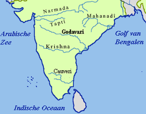
Geography
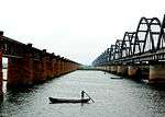
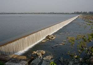
Some of the most beautiful locations are, the back waters of Balimela Dam, Satiguda Dam, Bonda Ghati (abode of the Bonda people, a prolific tribe listed amongst the Particularly Vulnerable tribal Groups of India).
Economy
This district has a Power Station at Balimela and the proposed Vijaywada-Ranchi corridor road will pass through it.
In 2006 the Ministry of Panchayati Raj named Malkangiri one of the country's 250 most backward districts (out of a total of 640).[2] It is one of the 19 districts in Odisha currently receiving funds from the Backward Regions Grant Fund Programme (BRGF).[2]
Demographics
According to the 2011 census Malkangiri district has a population of 612,727,[3] roughly equal to the nation of Solomon Islands[4] or the US state of Vermont.[5] This gives it a ranking of 523rd in India (out of a total of 640).[3] The district has a population density of 106 inhabitants per square kilometre (270/sq mi) .[3] Its population growth rate over the decade 2001-2011 was 21.53%.[3] Malkangiri has a sex ratio of 1016 females for every 1000 males,[3] and a literacy rate of 49.49%.[3]
Transport
Malkangiri district is a very remote part of Odisha. It is connected through Jeypore-Motu Highway and Govindpalli-Sileru Road. By rail Network, Malkangiri is not connected at all. Nearest Major Railway Stations are Koraput Railway Station, Jeypore, and Jagdalpur. Nearest airport at Vishakhapatnam- 322 km. via Koraput, Sunki, Vijayanagaram. Distance from other towns(from Malkangiri town)-
- Boipariguda-82 km
- Jeypore-105 km
- Koraput-126 km
- Sunabeda-145 km
- Sukma-30 km
- Bhadrachalam-176 km
- Jagdalpur-140 km via Sukma, Darbha
- Vijayanagaram-271 km
- Vishakhapatnam-257 km via Sileru
- Khammam-295 km
- Vijayawada-361 km via Kothagudem, Ibrahimpatnam
- Bhubaneswar-625 km
railway stations - 01 ; RTC depoits - 02
Politics
Vidhan sabha constituencies
The following is the 2 Vidhan sabha constituencies[6][7] of Malkangiri district and the elected members[8] of that area
| No. | Constituency | Reservation | Extent of the Assembly Constituency (Blocks) | Member of 14th Assembly | Party |
|---|---|---|---|---|---|
| 146 | Malkangiri | ST | Malkangiri (NAC), Kalimela, Malkangiri, Podia, Korukunda (part) | Manas Madkami | BJD |
| 147 | Chitrakonda | ST | Balimela (NAC), Mathili, Kudumulugumma, Khairaput, Korukonda (part) | Dambaru Sisa | BJD |
References
- ↑ http://ordistricts.nic.in/district_profile/dist_glance.php
- 1 2 Ministry of Panchayati Raj (September 8, 2009). "A Note on the Backward Regions Grant Fund Programme" (PDF). National Institute of Rural Development. Retrieved September 27, 2011.
- 1 2 3 4 5 6 "District Census 2011". Census2011.co.in. 2011. Retrieved 2011-09-30.
- ↑ US Directorate of Intelligence. "Country Comparison:Population". Retrieved 2011-10-01.
Solomon Islands 571,890 July 2011 est.
- ↑ "2010 Resident Population Data". U. S. Census Bureau. Retrieved 2011-09-30.
Vermont 625,741
- ↑ Assembly Constituencies and their EXtent
- ↑ Seats of Odisha
- ↑ "List of Member in Fourteenth Assembly". ws.ori.nic.in. Retrieved 19 February 2013.
MEMBER NAME
External links

| Governance |
|  |
|---|---|---|
| Topics | ||
| GI Products | ||
| Districts | ||
| Cities | ||
| Rivers |
|    | |||||||||||||||||||||||||
|---|---|---|---|---|---|---|---|---|---|---|---|---|---|---|---|---|---|---|---|---|---|---|---|---|---|---|---|
| Dams, barrages | |||||||||||||||||||||||||||
| Geographical features / regions | |||||||||||||||||||||||||||
| Riparian districts |
| ||||||||||||||||||||||||||
| Cities | |||||||||||||||||||||||||||
| Languages / people | |||||||||||||||||||||||||||
| Coalfields | |||||||||||||||||||||||||||
| Oil / gas fields | |||||||||||||||||||||||||||
| Industries |
| ||||||||||||||||||||||||||
| Transport | |||||||||||||||||||||||||||
| Pollution concerns, River basin's sustainable productivity & ecology |
| ||||||||||||||||||||||||||
| Related topics | |||||||||||||||||||||||||||
| Other basins | |||||||||||||||||||||||||||