Malakasa
| Malakasa Μαλακάσα | |
|---|---|
 Malakasa | |
|
Location within the regional unit 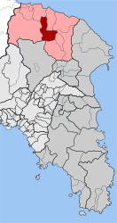 | |
| Coordinates: 38°14′N 23°48′E / 38.233°N 23.800°ECoordinates: 38°14′N 23°48′E / 38.233°N 23.800°E | |
| Country | Greece |
| Administrative region | Attica |
| Regional unit | East Attica |
| Municipality | Oropos |
| • Municipal unit | 30.195 km2 (11.658 sq mi) |
| Elevation | 220 m (720 ft) |
| Population (2011)[1] | |
| • Municipal unit | 1,049 |
| • Municipal unit density | 35/km2 (90/sq mi) |
| Time zone | EET (UTC+2) |
| • Summer (DST) | EEST (UTC+3) |
| Postal code | 190 11 |
| Area code(s) | 22950 |
| Vehicle registration | ZB-ZY |
Malakasa (Greek: Μαλακάσα) is a village and former community of East Attica in Greece. Since the 2011 local government reform it is part of the municipality Oropos, of which it is a municipal unit.[2] The municipal unit has an area of 10.450 km2.[3] The municipal unit Malakasa consists of the villages Malakasa (pop. 514 in 2011), Milesi (425) and Sfendali (110).
Malakasa is situated on the northern edge of the Parnitha mountain range and 9 km south of the South Euboean Gulf coast. It is 29 km north of Athens. Motorway 1 (Athens - Thessaloniki) passes south of the town. The Greek National Road 79 links Malakasa with Nea Palatia on the coast. Sfendali has a station on the railway from Athens to Thessaloniki.
Historical population
| Year | Village population | Community population |
|---|---|---|
| 1981 | 884 | - |
| 1991 | 654 | 1,168 |
| 2001 | 622 | 1,405 |
| 2011 | 514 | 1,049 |
References
- ↑ "Απογραφή Πληθυσμού - Κατοικιών 2011. ΜΟΝΙΜΟΣ Πληθυσμός" (in Greek). Hellenic Statistical Authority.
- ↑ Kallikratis law Greece Ministry of Interior (Greek)
- ↑ "Population & housing census 2001 (incl. area and average elevation)" (PDF) (in Greek). National Statistical Service of Greece.
External links
- GTP Travel Pages (Municipality) (in English and Greek)
- dhmoi.gr - Malakassa
 |
Oropioi | Markopoulo Oropou | Kalamos | |
| Avlonas | |
Kapandriti | ||
| ||||
| | ||||
| Acharnes | Afidnes | Polydendri |
This article is issued from Wikipedia - version of the 11/28/2016. The text is available under the Creative Commons Attribution/Share Alike but additional terms may apply for the media files.