Makardaha
| Makardaha মাকড়দহ | |
|---|---|
| Census Town | |
 Makardaha Location in West Bengal, India | |
| Coordinates: 22°37′N 88°14′E / 22.62°N 88.24°ECoordinates: 22°37′N 88°14′E / 22.62°N 88.24°E | |
| Country |
|
| State | West Bengal |
| District | Howrah |
| Population (2011) | |
| • Total | 8,713 |
| Languages | |
| • Official | Bengali, English |
| Time zone | IST (UTC+5:30) |
| Lok Sabha constituency | Sreerampur |
| Vidhan Sabha constituency | Domjur |
| Website |
howrah |
Makardaha is a census town in Domjur (community development block) under Domjur police station in Sadar subdivision of Howrah district in the Indian state of West Bengal.[1] The place has attained some renown as the house of the deity Makarchandi and on account of the excellent academic performance of the students of the local school.
Geography
Makardaha is located at 22°37′N 88°14′E / 22.62°N 88.24°E.[2]
Saraswati River used to flow past the village.[3]
Demographics
As per 2011 Census of India Makardaha had a total population of 8,713 of which 4,428 (51%) were males and 4,285 (49%) were females. Population below 6 years was 756. The total number of literates in Makardaha was 7,048 (88.58 % of the population over 6 years).[4]
Makardaha was part of Kolkata Urban Agglomeration in 2011 census.[5]
As of 2001 India census,[6] Makardaha had a population of 6,730. Males constitute 51% of the population and females 49%. Makardaha has an average literacy rate of 79%, higher than the national average of 59.5%: male literacy is 82%, and female literacy is 75%. In Makardaha, 9% of the population is under 6 years of age.
Transport
Makardaha is 13.50 kilometres (8.39 mi) from Howrah Station.[7] It is part of the Kolkata Suburban Railway railway system.
It is on the Howrah–Munsirhat–Domjur road.[3]
Culture
The temple of Makarchandi is the main attraction here. The original temple is believed to have been built by Srimanta Sadagar, who received the command of the goddess in a dream while sailing along the once mighty Saraswati River. Three pieces of stone lying in the present temple complex are believed to be the remains of the old temple. The present temple, along with a Shiva temple, natmandap etc., was built in 1743 by Ramkanta Kunduchoudhury, zamindar of Mahiari. The temple with a height of about 40 feet (12 m) was renovated by the Birla Trust. A fair is organised on the occasion of Panchamdol.[3]
References
- ↑ "District-wise list of stautory towns". Census Commission of India. Retrieved 28 January 2009.
- ↑ "Yahoo maps of Makardaha". Yahoo maps. Retrieved 29 November 2008.
- 1 2 3 Santra, Tarapada and Bandopadhyay, Amiya Kumar, Howrah Jelar Purakirti (in Bengali), p. 110, Government of West Bengal
- ↑ "C.D. Block Wise Primary Census Abstract Data(PCA)". 2011 census: West Bengal – District-wise CD Blocks. Registrar General and Census Commissioner, India. Retrieved 11 May 2016.
- ↑ "Provisional Population Totals, Census of India 2011" (PDF). Constituents of Urban Agglomeration Having Population Above 1 Lakh. Census of India 2011. Retrieved 11 May 2016.
- ↑ "Census of India 2001: Data from the 2001 Census, including cities, villages and towns (Provisional)". Census Commission of India. Archived from the original on 2004-06-16. Retrieved 2008-11-01.
- ↑ "Distances in kilometers between stations" (PDF). Indian Railways. Retrieved 7 February 2009.
Cities, towns and locations in Howrah District | |
|---|---|
| Cities, municipal and census towns | |
| Locations other than cities and towns | |
| Related topics |
|
| Bankura | 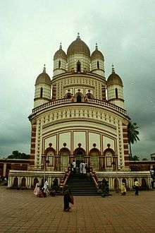 | |
|---|---|---|
| Bardhaman |
| |
| Birbhum |
| |
| Hooghly | ||
| Howrah | ||
| Jalpaiguri | ||
| Kolkata | ||
| Nadia |
| |
| North 24 Parganas |
| |
| Medinipur | ||
| Centres | ||