Makalu
| Makalu | |
|---|---|
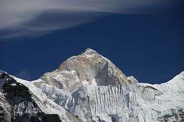 Makalu from the southwest | |
| Highest point | |
| Elevation |
8,485 m (27,838 ft) [1] Ranked 5th |
| Prominence | 2,386 m (7,828 ft) |
| Isolation | 17 kilometres (11 mi) |
| Listing |
Eight-thousander Ultra |
| Coordinates | 27°53′21″N 87°05′19″E / 27.88917°N 87.08861°ECoordinates: 27°53′21″N 87°05′19″E / 27.88917°N 87.08861°E |
| Geography | |
 Makalu Location in Nepal, on the border with China | |
| Location | Khumbu, Nepal / Tibet, China |
| Parent range | Mahalangur Himalaya |
| Climbing | |
| First ascent | May 15, 1955 by Lionel Terray and Jean Couzy |
| Easiest route | snow/ice climb |
Makalu (Nepal: मकालु; China: Makaru) is the fifth highest mountain in the world at 8,485 metres (27,838 ft). It is located in the Mahalangur Himalayas 19 km (12 mi) southeast of Mount Everest, on the border between Nepal and China. One of the eight-thousanders, Makalu is an isolated peak whose shape is a four-sided pyramid.
Makalu has two notable subsidiary peaks. Kangchungtse, or Makalu II (7,678 m) lies about 3 km (2 mi) north-northwest of the main summit. Rising about 5 km (3.1 mi) north-northeast of the main summit across a broad plateau, and connected to Kangchungtse by a narrow, 7,200 m saddle, is Chomo Lonzo (7,804 m).
Climbing history
The first climb on Makalu was made by an American team led by William Siri in the spring of 1954. The expedition was composed of Sierra Club members including Allen Steck, and was called the California Himalayan Expedition to Makalu.[2] They attempted the southeast ridge but were turned back at 7,100 m (23,300 ft) by a constant barrage of storms. A New Zealand team including Sir Edmund Hillary was also active in the spring, but did not get very high due to injury and illness. In the fall of 1954, a French reconnaissance expedition made the first ascents of the subsidiary summits Kangchungtse (October 22: Jean Franco, Lionel Terray, Sardar Gyaltsen Norbu and Pa Norbu) and Chomo Lonzo (October 30(?): Jean Couzy and Terray).[3]
Makalu was first climbed on May 15, 1955 by Lionel Terray and Jean Couzy of a French expedition led by Jean Franco. Franco, G. Magnone and Sardar Gyaltsen Norbu summitted the next day, followed by Bouvier, S. Coupe, Leroux and A. Vialatte on the 17th. This was an amazing achievement at the time to have the vast majority of expedition members summit, especially on such a difficult peak. Prior to this time, summits were reached by 1-2 people at most with the rest of teams providing logistical support before turning around and heading home. The French team climbed Makalu by the north face and northeast ridge, via the saddle between Makalu and Kangchungtse (the Makalu-La), establishing the standard route.[3]
Notable ascents

- 1955 North Face to Northeast Ridge FA by Lionel Terray and Jean Couzy of France.[3]
- 1970: Southeast Ridge FA of ridge attempted by the Americans in 1954 was made by Y. Ozaki and A. Tanaka from Japan on May 23.
- 1971: The very technical West Pillar route was climbed in May by Frenchmen B. Mellet and Y. Seigneur.[3]
- 1975: South Face - an expedition led by Aleš Kunaver reached the top of Makalu up its steep southern side, becoming the first Slovenes to summit an eight-thousander. The first amongst them was Stane Belak. This was the third ascent of an eight-thousand meter peak by a great mountain face and the highest peak successfully summitted without supplementary oxygen (Marjan Manfreda).[4]
- 1980: The second ascent of the West Pillar was completed in May by John Roskelley (summit), Chris Kopczynski, James States and Kim Momb, without Sherpa support and without bottled oxygen.[5]
- 1981: On 15 October renowned Polish climber Jerzy Kukuczka ascended Makalu via a new route up the north-western side and north crest. Kukuczka climbed solo, in Alpine style, without supplemental oxygen.
- 1982 : On 10 October Polish climber Andrzej Czok ascended Makalu via West face till 8000m and north-western ridge, Camp IV was reached by two more climbers - Janusz Skorek and Andrzej Machnik but when first peak attempt failed, only Czok decide to try one more time.
- 1988: Frenchman Marc Batard climbed in one day (after camps were set up) to the summit via the West Buttress on April 27.[6]
- 1989: Direct South Face, solo new start by Frenchman Pierre Beghin to 1975 Yugoslav route.[7]
- 1990: First female ascent, Kitty Calhoun via the West Pillar route[8]
- 1997: After seven failed attempts between 1977 and 1996, the West face was finally conquered. A Russian expedition led by Sergey Efimov brought Alexei Bolotov, Yuri Ermachek, Dmitri Pavlenko, Igor Bugachevski and Nikolai Jiline to the summit. This ascent won the 1997 Piolet d'Or,
- 2006: On or about January 27 the French mountaineer Jean-Christophe Lafaille disappeared on Makalu while trying to make the first winter ascent.[9]
- 2008: Brazilian Waldemar Niclevicz and Irivan Burda arrived on May 11, 2008 to the top of Makalu
- 2009: Makalu was first climbed in winter on February 9, 2009 by Italian Simone Moro and Kazakh Denis Urubko.[10][11] It was the final Nepali eight-thousander to be climbed in winter conditions. Moro had previously made the first winter ascent of Shishapangma in winter 2005 with Pole Piotr Morawski.
Makalu is one of the harder eight-thousanders, and is considered one of the most difficult mountains in the world to climb. The mountain is notorious for its steep pitches and knife-edged ridges that are completely open to the elements. The final ascent of the summit pyramid involves technical rock/ice climbing.

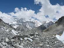
Makalu-Barun Valley
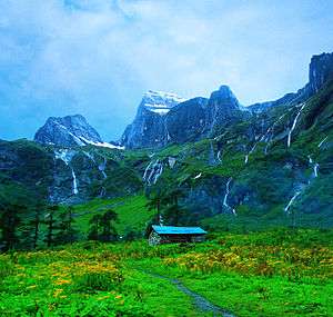
Makalu-Barun Valley is a Himalayan glacier valley situated at the base of Makalu in the Sankhuwasabha district of Nepal. This valley lies entirely inside the Makalu Barun National Park.
Barun Valley provides stunning contrasts, where high waterfalls cascade into deep gorges, craggy rocks rise from lush green forests, and colorful flowers bloom beneath white snow peaks. This unique landscape shelters some of the last pristine mountain ecosystems on Earth. Rare species of animals and plants flourish in diverse climates and habitats, relatively undisturbed by human kind.
View
References
- ↑ The height is often given as 8,481 m or 8,485 m.
- ↑ Daniel Duane (September–October 2005). "Career Climber". Sierra Magazine. Sierra Club. Archived from the original on July 14, 2007.
- 1 2 3 4 Baume, Louis C. (1979). Sivalaya. Seattle, WA, USA: The Mountaineers. pp. 74–75. ISBN 0-916890-71-6.
- ↑ (Slovene) http://www.gore-ljudje.net/novosti/35160/
- ↑ Roskelley, John (1993). Stories Off The Wall. Seattle, WA, USA: The Mountaineers. pp. 137–152. ISBN 0-89886-609-X.
- ↑ Batard, Marc (1989). "Makalu West Buttress, One-Day Solo Ascent". American Alpine Journal. New York, NY, USA: American Alpine Club. 31 (63): 188. ISBN 0-930410-39-4.
- ↑ Beghin, Pierre (1990). "Cold Sweat on Makalu". American Alpine Journal. New York, NY, USA: American Alpine Club. 32 (64): 1–6. ISBN 0-930410-43-2.
- ↑ Krakauer, Jon (June 1993). "What's a Nice Southern Girl Doing in a Place Like This?". Outside. Retrieved 2016-04-06.
- ↑ "Jean-Christophe Lafaille obituary". The Independent. 2006-02-09. Archived from the original on 2008-01-20. Retrieved 2007-10-27.
- ↑ "Simone Moro and Denis Urubko: Makalu first winter ascent". PlanetMountain.com. Retrieved 2009-02-10.
- ↑ "Simone Moro and Denis Urubko make winter history on Makalu". MountEverest.net. Retrieved 2009-03-01.
Further reading
- Franco, Jean, Makalu : 8470 metres (27,790 feet) : the highest peak yet conquered by an entire team, J. Cape, 1957.
- Terray, Lionel (1963). Conquistadors of the Useless. Victor Gollancz Ltd. pp. 323–335. ISBN 0-89886-778-9.
External links
| Wikimedia Commons has media related to Makalu. |
- Makalu on SummitPost
- Makalu on Himalaya-Info.org (German)
- Makalu on Peakware
- Ascents and fatalities statistics