Main Line (Long Island Rail Road)
| LIRR Main Line | |
|---|---|
 At the Grand Avenue overpass | |
| Overview | |
| Type | Commuter rail |
| System | Long Island Rail Road |
| Status | Operational |
| Locale | Long Island, New York, USA |
| Termini |
Long Island City Greenport |
| Stations | 29 passenger, 1 employee-only |
| Services | |
| Operation | |
| Owner | Long Island Rail Road |
| Operator(s) | Long Island Rail Road |
| Technical | |
| Track gauge | 4 ft 8 1⁄2 in (1,435 mm) |
| Electrification |
750 V (DC) third rail (west of Ronkonkoma) |
The Main Line is a rail line owned and operated by the Long Island Rail Road in the U.S. state of New York. It begins in Long Island City and runs along the middle of Long Island about 95 miles (153 km) to Greenport. A mile east of Long Island City (east of Hunterspoint Avenue) the four tracks of the East River Tunnels join the two tracks from Long Island City; most Main Line trains use those tunnels rather than running to or from Long Island City.
Continuing east, five branches split from the Main Line; in order from west to east, they are:
- Port Washington Branch (at WOOD Interlocking in Woodside, Queens)
- Hempstead Branch (at QUEENS Interlocking along the Queens / Nassau County border)
- Oyster Bay Branch (at NASSAU Interlocking, east of Mineola station)
- Port Jefferson Branch (at DIVIDE Interlocking, east of Hicksville station)
- Central Branch (at BETH Interlocking, east of Bethpage station) – a single non-electrified track with no stations, connecting the Main Line to the Montauk Branch
Public timetables refer to the Main Line east of Hicksville as the Ronkonkoma Branch.
Trains on the Main Line between Long Island City and Ronkonkoma are governed by Automatic Block and Interlocking Signals and by Automatic Train Control (known as Automatic Speed Control by the LIRR). East of Ronkonkoma to Greenport trains operate in non-signalled or "Dark Territory", with all train movements governed by train orders and timetable authority.[1]
Route description and current train service
The Main Line has two tracks from just east of Long Island City to Harold Interlocking (HAROLD, 0.6 miles (0.97 km) northwest of the Woodside station), where the four track Northeast Corridor from Penn Station in Manhattan joins the Main Line after passing through the East River Tunnels.[2] East of HAROLD,[ua 1] the four-track Main Line runs adjacent to the two-track Port Washington Branch until, 0.7 miles (1.1 km) southeast of the Woodside station, the Port Washington Branch turns northeastward. The Main Line continues southeast with four tracks to JAY Interlocking where it meets the Atlantic Branch and Montauk Branch at the west end of Jamaica station. Eight platform tracks and two bypass tracks pass Jamaica station, along with a few yard tracks and two former freight tracks on the south side that can be used by trains bypassing Jamaica. At HALL Interlocking[ua 2] just east of the station there are eight through tracks: two usually westward tracks for Main Line and Montauk trains, two Atlantic Branch tracks that are about to duck under and turn southeast, two usually eastward Main Line/Montauk tracks, and the two former freight tracks on the south side of Hall tower.
Just east of there, Montauk Branch trains get their own two tracks in the center of the four Main Line tracks until the Montauk tracks fly over[ua 3] the other tracks and head southeast. At QUEENS Interlocking, just inside Nassau County between the Queens Village and Bellerose stations, the four-track Main Line splits into the two-track Main Line and the two-track Hempstead Branch; the four tracks continue parallel to Floral Park station where the Hempstead Branch curves away southward. The two-track Main Line continues east to Mineola where the two track Oyster Bay Branch begins and curves to the north. The line continues east from Mineola to Hicksville where the two track Port Jefferson Branch begins and curves to the north. To FARM Interlocking (just east of Farmingdale station), the Main Line has two tracks, then is single track with passing sidings to Greenport except for a three-mile stretch of double track from west of Deer Park to east of Brentwood. The Main Line was electrified between Hicksville and Ronkonkoma in 1987, requiring construction of high platforms along that stretch. LIRR plans to eventually complete double track to Ronkonkoma as part of the Ronkonkoma Branch Double Track Project. Phase I of construction, which will double track the five mile stretch between Central Islip and Ronkonkoma stations, began in April 2014.
The Main Line west of Jamaica to Harold Interlocking is the only line that can reach the East River Tunnels, so all trains bound for Penn Station use it. The portion between HAROLD and the Long Island City station is used by trains originating or terminating at Hunterspoint Avenue and LIC.

East of Jamaica station, the Main Line is used by all trains on the Hempstead Branch, the Oyster Bay Branch (diverging east of Mineola), the Port Jefferson Branch (diverging east of Hicksville), and the Ronkonkoma Branch (terminating at Ronkonkoma, the easterly limits of the line's electrification). Some Montauk Branch trains use the Main Line on their way to Babylon via the Central Branch, diverging east of Bethpage.
Only a few diesel shuttle trains, informally known as scoots, operate between Ronkonkoma and Greenport.
History
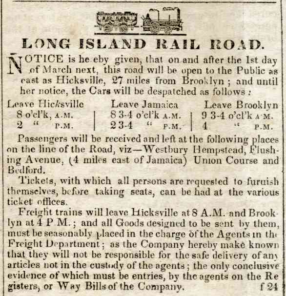
The Main Line opened beyond Jamaica to Hicksville on March 1, 1837; shortly afterwards, the Panic of 1837 severely curtailed construction. It was extended to Farmingdale on October 15, 1841, Deer Park on March 14, 1842, Brentwood on June 24, Central Islip on July 14, and Yaphank on June 26, 1844. An opening excursion to Greenport was operated on July 27, 1844, and revenue service began over the full line on July 29.[3][4][5][6]
The line was electrified in stages throughout the early 20th Century. Electrification between Long Island City and Jamaica began on September 8, 1910. Prior to this segment however, the line was electrified from to Queens Village and Belmont Park in October 2, 1905, and then to Floral Park, in May 26, 1908. Hempstead Branch stations southeast of Floral Park were electrified on the same date, but stations along the Main Line east of Floral Park to Mineola were electrified by October 1926. The Oyster Bay Branch, which left the main line at Mineola was partially electrified in June 1934, up north to East Williston station. The line was electrified to Hicksville, and then north along the Port Jefferson Branch to Huntington in 1970, and finally electrification was extended from Hicksville to Ronkonkoma in 1987.[7]
Major infrastructure improvements
Second track between Farmingdale and Ronkonkoma
In 2012, the MTA approved a project to build a second track between Ronkonkoma and Farmingdale, a well anticipated event since the electrification of the rail line in the 1980s.[8] Currently, the only areas east of Farmingdale with two tracks are between Deer Park and Brentwood stations (including those stations), at Central Islip station, and finally at Ronkonkoma itself. This construction will take place on land already owned by the LIRR (acquired during the 1980s electrification of this segment) so no land acquisition is required. It will include upgrades to switches, grade crossings, and station facilities.[8] The project will be done in two phases:
- Phase 1: Constructing the second electrified track to the North of the current one along the 4-mile stretch from Ronkonkoma to Central Islip, followed by a continuation of it with the track being constructed South of the current one in between Central Islip and Brentwood. This is currently underway and should be completed by mid to late 2016.[9][10]
- Phase 2: Construction of the second electrified track will continue with the new track being laid down South of the current one from West of Deer Park through Wyandanch, past Pinelawn station to the East end of FARM Interlocking at Republic. Phase 2 will commence once Phase 1 is completed and should be completed by late 2018 to 2019. Additional construction includes rehabilitation of grade crossings, demolition of pedestrian bridges, and a second platform at Wyandanch (the station currently has only one track and platform).[9][11]
The project officially got underway in August 2015, and one year later thanks to a NTC (New Track Construction) machine, a few weekends that saw no service due to grading, the second track was officially laid between Ronkonkoma and Central Islip with some work still to be done. In addition a few grade crossings were closed for two days to add the second track to the crossings. As far as Phase II, in August 2016 workers started to clear brush and make space East of Deer Park near Wyandanch.
The benefits of the project include increased operational flexibility, increased reverse-peak service between Farmingdale and Ronkonkoma, and increased off-peak service between Hicksville and Ronkonkoma - operating half-hourly instead of just hourly - as well as increased resilience for the system, as this additional capacity will allow the Main Line to better serve as a substitute for South Shore lines in case of a disturbance caused by extreme weather.[8]
Mid-Suffolk Yard
In 2015, the MTA conducted environmental studies to expand the existing rail yard in Ronkonkoma. This expansion, called the Mid-Suffolk Yard, will add 11 new tracks, increasing the number of total tracks from 12 at present to 23.[12] The expansion will use space already owned by the MTA located immediately to the south of the existing rail yard and north of MacArthur Airport. The increase in storage space will allow the MTA to increase peak-hour service once East Side Access is complete and service to Grand Central begins. The project is budgeted for $76.6 million, and the MTA expects to finish construction by late 2018.[13] Other locations along the line considered for a new electric yard but rejected include Deer Park, Central Islip, and Yaphank. Reasons given include the cost of land acquisition, the fact that the Deer Park option would impact several grade crossings, duplicate employee facilities and would not benefit customers east of Deer Park, the fact that the proposed Central Islip site (Connetquot River State Park) is State parkland, and the high cost of electrification and station upgrades between Ronkonkoma and Yaphank.[14]
Possible reopening of Republic Station
The MTA has expressed interest in reopening Republic station, located between Farmingdale and Pinelawn, which closed in 1987 as part of electrification between Hicksville and Ronkonkoma. At the time, the station only had about a dozen riders daily, which didn't make it very cost-effective to upgrade the station to support electric railcars.
However, within the last decade, there has been an increased amount of commercial and residential development along Route 110 near the station, which has led to the MTA looking into re-opening Republic station.
The reopened station would serve the Route 110 corridor, a major north-south commercial route.[15] The station was deferred from the MTA's 2010-2014 budget due to budgetary issues, but revived in 2012.[16][17] The MTA budgeted $5 million in 2015 to design a new station and carry out environmental studies, although construction itself has not been funded yet.[18][19] The rebuilt station will have two new 12-car platforms, and ADA-compliant ramps.
Signalling between Ronkonkoma and Yaphank
The 46 miles between Ronkonkoma and Greenport is one of the few dark territory areas on the Long Island Rail Road that does not have signals. The MTA budgeted $29 million in 2015 to add signals along the 10-mile segment from Ronkonkoma to Yaphank. This upgrade will install signals, track circuits, and automatic speed control (ASC).[20]
Third track between Queens Village and Hicksville
To accommodate an expected increase in Long Island Rail Road ridership once the East Side Access project to Grand Central Terminal is completed and to expand local and reverse peak service, the Metropolitan Transportation Authority has proposed to build a third Main Line track from Queens Village to Hicksville in the future.[21][22] Components of the project include purchasing properties in the track's right of way, eliminating grade crossings (in conjunction with NYSDOT), relocating existing stations, and reconfiguring Mineola Station. The project has been stalled by fierce opposition from the villages of Floral Park, New Hyde Park, and Garden City,[23][24][25] which say the construction and the resulting increased train service will reduce the quality of life in their neighborhoods. These villages support station improvements and the elimination of grade crossings in lieu of third track expansion; however, the MTA has long insisted that a third track is a necessary component of LIRR's East Side Access expansion.[26] In March 2015, LIRR president Patrick Nowakowski declared that the LIRR would not proceed with the project without the support of the local communities.[27]
Small segments of the third track have been built already or will be built, however. One segment is between Merillon Avenue and Mineola, built in the vicinity of Herricks Road during the grade crossing elimination project that took place in 1998.[28] Another segment will be built as part of the upcoming station renovation at Hicksville. This construction will connect Track 1 at Hicksville station to the North Siding track located about 3,000 feet west of the station. This short segment, when completed, will essentially serve as the eastern end of the future third track; it will also allow for a slight increase in peak-hour service.[29][30] The MTA has also left provisions for a third track in construction of other infrastructure along the line, such as the Mineola Intermodal Center located adjacent to Mineola station, Mineola Blvd Bridge, Roslyn Road Underpass in Mineola, and the replacement Ellison Avenue Bridge over the Main Line in Westbury.[31][32][33][34]
In January 2016, Governor Andrew Cuomo announced a transportation improvement plan which included several million dollars in funding to restart third track development.[35][36] Governor Cuomo said that unlike previous third track proposals, his plan involves building the third track within existing LIRR right of way, which will reduce the number of existing homes and businesses affected by installation of the third track.[37] While previous proposals would have affected around 250 properties, 80 of which were homes, Governor Cuomo's proposal would only require taking property from 50 properties in total, including around 20 homes.[37] This reduction in properties affected be accomplished by building a shorter third track than previous proposals, resulting in a 9.8-mile (15.8 km) three-track segment instead of the previously planned 11.5-mile (18.5 km) segment.[35][38]
Stations
Hempstead Branch trains run on separate tracks east of Queens Village (and, east of Floral Park, split to the south), Oyster Bay Branch trains split off after Mineola, and Port Jefferson Branch trains split off after Hicksville. Montauk Branch trains that use the Main Line and Central Branch split off after Bethpage, but only some stop at Mineola and Hicksville east of Jamaica.
| Zone | Station name | Miles (km) from NYP[39] |
Ronkonkoma Local |
Port Jefferson Local |
Date opened |
Date closed |
Connections / Notes |
|---|---|---|---|---|---|---|---|
| 1[lower-alpha 1] | Pennsylvania Station |
0.0 (0.0) | ● | ● | 1910 | | |
| Long Island City |
-[lower-alpha 3] | ♦ | ♦ | 1854 | |||
| Hunterspoint Avenue | -[lower-alpha 3] | ♦ | ♦ | 1860 | |||
| Woodside |
4.9 (7.9) | ● | ● | 1869[40] | |||
| Winfield | 1864 | 1929 | |||||
| Port Washington Branch diverges | |||||||
| Grand Street | 1913 | 1925 | |||||
| Rego Park | 1928 | 1962 | |||||
| Matawok | 1922 | 1925 | |||||
| Forest Hills |
8.5 (13.7) | ¤ | ¤ | 1906 | |||
| Hopedale | 1875 | c. 1884 | |||||
| Kew Gardens |
8.8 (14.2) | ¤ | ¤ | 1879 | Originally Maple Grove, then Kew | ||
| Westbridge[41] | 1916 | 1939 | Originally High Bridge | ||||
| Dunton | 1897 | 1939 | |||||
| 3 | Jamaica |
10.8 (17.4) | ● | ● | 1836 | Montauk, Oyster Bay, Port Jefferson, Ronkonkoma, and West Hempstead Branches | |
| Atlantic Branch diverges | |||||||
| Union Hall Street | 1890 | 1976 | Originally New York Avenue | ||||
| Canal Street | 1853[42] | 1899 | |||||
| Hillside | c. 1909 May 15, 1911 |
1911 1966 |
|||||
| Babylon and Montauk Branches diverge | |||||||
| Hillside Facility | No passengers[lower-alpha 4] | 1991 | Employee-only station | ||||
| Rockaway Junction, also called Woodhull Park[43] | 1875 or 1890[44] | c. 1905 | |||||
| Willow Tree[45] | March 1, 1837 | June 1872 | |||||
| Hollis | 13.4 (21.6) | | | ¤ | 1885 | Originally East Jamaica | ||
| Bellaire | 1837[46] | 1972 | Originally Flushing Avenue, then Brushville, then Interstate Park, then Brushville Road | ||||
| Queens Village | 15.0 (24.1) | | | ¤ | 1881 | |||
| Belmont Park Branch diverges | |||||||
| Queens / Nassau county line | |||||||
| 4 | |||||||
| Bellerose | | | | | 1898 | Hempstead Branch only | |||
| Hempstead Branch diverges | |||||||
| Floral Park | 16.7 (26.9) | | | ¤ | c. 1870 | Originally Plainfield, then Stewart Junction, then Hinsdale, then East Hinsdale | ||
| New Hyde Park |
18.0 (29.0) | | | ● | 1845 | Originally Hyde Park | ||
| Merillon Avenue |
19.1 (30.7) | | | ¤ | 1837 | Originally Clowesville, then Garden City | ||
| Mineola |
20.3 (32.3) | ¤ | ● | 1837[46] | Originally Hempstead, then Branch or Hempstead Branch | ||
| Oyster Bay Branch diverges | |||||||
| 7 | Carle Place |
22.2 (35.7) | | | ● | 1842[47] | Originally Carll Place | |
| Westbury |
23.2 (37.3) | | | ● | 1837[46] | |||
| New Cassel | November 1875 | March 1876 | |||||
| Hicksville |
26.6 (42.8) | ● | ● | 1837[46] | |||
| Port Jefferson Branch diverges Main Line is solely the Ronkonkoma Branch |
|||||||
| Grumman | 28.5 (45.9) | Through to Port Jefferson via Huntington |
1942 | 1985 | |||
| Bethpage |
29.7 (47.8) | ● | c. 1854[48] | Originally Jerusalem, then Central Park | |||
| Bethpage Junction | 1873 | ||||||
| Central Branch diverges | |||||||
| Farmingdale |
32.0 (51.5) | ● | 1841[49][50] | ||||
| Nassau / Suffolk county line | |||||||
| 9 | |||||||
| Republic | 33.0 (53.1) | 1940 | 1987 | ||||
| Pinelawn |
34.2 (55.0) | ¤ | c. 1890 | Originally Melville | |||
| Wyandanch |
36.5 (58.7) | ● | 1875 | Originally West Deer Park, then Wyandance | |||
| Edgewood | 1892 | 1914 | |||||
| Deer Park |
40.2 (64.9) | ● | 1842[51][52] | ||||
| Pilgrim State Hospital | c. 1931 | May 21, 1978 | |||||
| Thompson | 42.2 (67.9) | 1842[53] | 1869 | ||||
| Pineaire | 1915 | 1986 | |||||
| 10 | Brentwood |
42.9 (69.0) | ● | 1870 | Originally Modern Times | ||
| Suffolk | 44.7 (71.9) | 1842[54] | 1873 | ||||
| Central Islip |
45.4 (73.1) | ● | 1873 | ||||
| Central Islip State Hospital | |||||||
| Nichols Road | |||||||
| Lakeland |
50.2 (80.8) | 1843 | 1883 | Originally Lake Road | |||
| Ronkonkoma |
50.3 (81.0) | ● | 1883 | Eastern end of electrified service; originally Lake Ronkonkoma | |||
| Hermanville | 50.6 (81.4) | 1850 | |||||
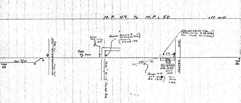
| Holbrook | 51.6 (83.0) | 1907 | 1962[55] | ||||
| Holtsville | 54.2 (87.2) | 1843 | 1998 | Originally Waverly[56] | |||
| Medford (limited service) |
55.9 (89.0) | ● | 1844[57] | ||||
| Bartlett's | 58.7 (94.5) | 1844 | 1880 | Originally Bellport | |||
| Fire Place | 1844[57] | 1845 | |||||
| 12 | Yaphank (limited service) |
60.4 (97.2) | ● | 1844 | Originally Milleville | ||
| Carman's River | 1844[57] | 1845 | |||||
| Upton Road | 1918 | 1922 | |||||
| Camp Upton | 1917 | 1922 | |||||
| Wampmissic | 65.1 (104.6) | c. 1847–1848 | |||||
| Manorville | 67.0 (107.8) | 1844 | c. 1968 | Originally St. George's Manor, then Manor | |||
| Calverton | 71.1 (114.4) | 1852 1880 |
1858 c. 1958 |
Originally Hulse Turnout, then Baiting Hollow | |||
| 14 | Riverhead (limited service) |
75.1 (120.9) | ● | 1844 | |||
| Aquebogue | June 1892 | July 1967 | |||||
| Jamesport | 80.2 (129.1) | 1844 | 1985 | ||||
| Laurel | 81.7 (131.5) | 1967 | |||||
| Mattituck (limited service) |
84.2 (135.5) | ● | 1844 | ||||
| Cutchogue | 87.2 (140.3) | 1844 | 1962 | ||||
| Peconic | 90.2 (145.2) | 1844 | 1970 | Originally Hermitage | |||
| Southold (limited service) |
91.9 (147.9) | ● | 1844 | ||||
| Greenport (limited service) |
96.1 (154.7) | ● | 1844 | ||||
| |||||||
| |||||||
Coordinates
References
- ↑ "Blogger". thelirrtoday.com. (registration required (help)).
- ↑ The tunnels and the track to Penn Station are not owned by LIRR, but by Amtrak.
- ↑ "PRR Chronology, 1837" (PDF). (98.8 KiB), June 2004 Edition
- ↑ "PRR Chronology, 1841" (PDF). (60.7 KiB), May 2004 Edition
- ↑ "PRR Chronology, 1842" (PDF). (70.6 KiB), May 2004 Edition
- ↑ "PRR Chronology, 1844" (PDF). (41.4 KiB), May 2004 Edition
- ↑ "LIRR Branch Notes". trainsarefun.com.
- 1 2 3 "Long Island Rail Road Double Track Project" (PDF). mta.info. Retrieved April 10, 2015.
- 1 2 "Double Track' Information Center Opens Today at Ronkonkoma Station as Part of LIRR Public Outreach". mta.info. January 16, 2013. Retrieved April 10, 2015.
The first phase includes an environmental review and, after completion of that review, a design of the entire project and construction of a four mile segment between Ronkonkoma and Central Islip. This phase is already completely funded and tentatively scheduled for completion by late 2016. Phase two – which requires $297 million and is not yet funded - will stretch a second track from Central Islip all the way to Farmingdale by the end of 2018.
- ↑ "Double Track Project - Phase 1" (PDF). mta.info. Retrieved April 10, 2015.
- ↑ "MTA 2015-2019 Capital Program" (PDF). mta.info. Retrieved October 31, 2015.
- ↑ "Mid-Suffolk Yard". mta.info.
- ↑ "Mid-Suffolk Yard Schedule". mta.info. Retrieved November 2, 2015.
- ↑ "Mid-Suffolk Yard Alternatives Analaysis" (PDF). mta.info. Retrieved November 2, 2015.
- ↑ "Connect Long Island: Double Track Main Line & TODs" (PDF). Transportation Research Forum. April 3, 2014. Retrieved July 7, 2015.
- ↑ Castillo, Alfonso A. (April 26, 2010). "Plans for Republic Airport LIRR station put on hold". Newsday. Retrieved July 6, 2015.
- ↑ Hinko, Christy (June 1, 2012). "Senators Announce $138 Million To Advance New Republic Train Station". Farmingdale Observer. Retrieved July 6, 2015.
- ↑ "MTA 2015-2019 Capital Program, page 88" (PDF). Retrieved November 2, 2015.
- ↑ "MTA 2015-2019 Capital Program, page 204" (PDF). Retrieved November 2, 2015.
- ↑ "MTA 2015-2019 Capital Program, page 96" (PDF). Retrieved November 2, 2015.
- ↑ "MTA - Planning Studies". Metropolitan Transportation Authority. Archived from the original on March 6, 2014.
- ↑ "Main Line Corridor Improvements Project Presentation" (PDF). Metropolitan Transportation Authority. Retrieved January 7, 2016.
- ↑ Stephanie Mariel Petrellese (November 11, 2005). "Floral Park Mayor To Address LIRR Expansion". The Garden City News. Retrieved December 23, 2006.
- ↑ Carisa Keane (June 24, 2005). "Residents: MTA/LIRR Needs to Get on Right Track". New Hyde Park Illustrated News. Retrieved December 23, 2006.
- ↑ Stephanie Mariel Petrellese (December 15, 2006). "Village Meets With LIRR On "Third Track" Project". The Garden City News. Retrieved December 23, 2006.
- ↑ Nardiello, Carolyn (September 16, 2008). "Third-Track Plan Isn't Dead, L.I.R.R. Insists". The New York Times. Retrieved July 31, 2012.
- ↑ Castillo, Alfonso A. (March 3, 2015). "3rd track plan conditional on community support, LIRR chief says". Newsday. Retrieved October 20, 2015.
- ↑ Robert Gearty (April 22, 1998). "END'S NEAR FOR A KILLER LIRR X'ING". New York Daily News. Retrieved November 2, 2015.
- ↑ "Governor Cuomo Announces Final Design for Revitalized Hicksville Station". Metropolitan Transportation Authority. February 24, 2015. Retrieved November 2, 2015.
- ↑ "LIRR finalizes Hicksville Station design; includes East Side Access work". RT&S. February 24, 2015. Retrieved January 7, 2016.
- ↑ "$24.3 MILLION LIRR ROAD CROSSING ELIMINATION PROJECT IN MINEOLA COMPLETED". New York State Department of Transportation. December 31, 2008. Retrieved November 4, 2015.
- ↑ "National Steel Bridge Alliance 2009 Bridge Prize Competition" (PDF). Retrieved November 4, 2015.
- ↑ "Application for Transportation Investment Generating Economic Recovery (TIGER) Funds Ellison Avenue Bridge Reconstruction, page 3" (PDF). Metropolitan Transportation Authority. Retrieved November 2, 2015.
- ↑ "40,000 Customers Facing Delays This Weekend, Oct. 24-25, as LIRR Installs a New Bridge in Westbury". Metropolitan Transportation Authority. October 22, 2015. Retrieved November 2, 2015.
- 1 2 Fitzsimmons, Emma G. (January 5, 2016). "Cuomo Revives Long-Stalled Plan to Add Track to L.I.R.R.". The New York Times. p. A18. Retrieved January 7, 2016.
- ↑ Third Main Line Track project web site
- 1 2 Madore, James T. (January 5, 2016). "Andrew Cuomo tells Long Island Association he'll push LIRR third track, LI Sound tunnel". Newsday. Retrieved January 7, 2016.
- ↑ "LIRR Main Line Expansion Will Ease Commuting and Attract Businesses and Jobs" (Press release). Metropolitan Transportation Authority. January 5, 2016. Retrieved January 7, 2016.
- ↑ Station pages linked from LIRR Stations
- ↑ Vincent F. Seyfried, The Long Island Rail Road: A Comprehensive History, Part Two: The Flushing, North Shore & Central Railroad, © 1963
- ↑ "WESTBRIDGE". arrts-arrchives.com.
- ↑ ‹The template Cite BDE is being considered for deletion.› "Travel". Brooklyn Daily Eagle. Brooklyn, NY. June 16, 1853. p. 4.
- ↑ "HILLSIDE STATION". arrts-arrchives.com.
- ↑ ‹The template Cite BDE is being considered for deletion.› "Rapid Transit Extension". Brooklyn Daily Eagle. Brooklyn, NY. June 24, 1890. p. 1.
- ↑ "CABIN 10 JAMAICA". arrts-arrchives.com.
- 1 2 3 4 Brooklyn Advocate, Long Island Rail Road, February 1837
- ↑ ‹The template Cite BDE is being considered for deletion.› "Long Island Railroad Company". Brooklyn Daily Eagle. Brooklyn, NY. May 28, 1842. p. 3.
- ↑ "RAILROADS". New York Times. April 13, 1854. p. 7. Retrieved April 7, 2008.
- ↑ "The Long Delay at Hicksville". Newsday.
- ↑ "Brooklyn Eagle v1, #1 (LIRR timetable)". Brooklyn Eagle. October 26, 1841. This is the very first edition of the paper. (Whether "late Bethpage" is meant to indicate 1> a flag stop at the community near Merritts Road, or 2> that the area near the Farmingdale LIRR station had lately been called Bethpage, or 3> that the Merrits Road community had been a temporary stop until the Farmingdale station was completed has not yet been determined.)
- ↑ ‹The template Cite BDE is being considered for deletion.› "untitled". Brooklyn Daily Eagle. Brooklyn, NY. March 14, 1842. p. 2.
- ↑ ‹The template Cite BDE is being considered for deletion.› "Long Island Railroad Company". Brooklyn Daily Eagle. Brooklyn, NY. March 16, 1842. p. 3.
- ↑ ‹The template Cite BDE is being considered for deletion.› "Long Island Railroad". Brooklyn Daily Eagle. Brooklyn, NY. June 29, 1842. p. 2.
- ↑ ‹The template Cite BDE is being considered for deletion.› "untitled". Brooklyn Daily Eagle. Brooklyn, NY. August 6, 1842. p. 2.
- ↑ Holbrook Station @ Ronkonkoma MP 49-50; October 1957(TrainsAreFun.com)
- ↑ May 13, 1912, Photo @ Ron Ziel collection (Unofficial LIRR History Website)
- 1 2 3 ‹The template Cite BDE is being considered for deletion.› "Long Island Railroad Co". Brooklyn Daily Eagle. Brooklyn, NY. June 24, 1844. p. 2.
External links
- "Mainline (The LIRR Today)". (registration required (help)).
| Wikimedia Commons has media related to: |
| Main routes |   | ||||||
|---|---|---|---|---|---|---|---|
| Branch services | |||||||
| Freight operations |
| ||||||
| Defunct branches | |||||||
| Acquired railroads | |||||||
| Other | |||||||