Mahantango Formation
| Mahantango Formation Stratigraphic range: Middle Devonian, ~387 Ma | |
|---|---|
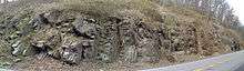 Outcrop of the Mahantango on Rt. 522, Fulton County, Pennsylvania | |
| Type | Geological formation |
| Unit of | Hamilton Group |
| Sub-units | See: Description |
| Underlies | Harrell Shale |
| Overlies | Marcellus Formation |
| Lithology | |
| Primary | Shale |
| Other | Limestone, Siltstone |
| Location | |
| Region |
Appalachian Basin of eastern North America |
| Extent | New York to Maryland |
| Type section | |
| Named for | Mahantango Creek |
The Devonian Mahantango Formation is a mapped bedrock unit in Pennsylvania, New Jersey, New York and Maryland. It is named for the North branch of the Mahantango Creek in Perry and Juniata counties in Pennsylvania. It is a member of the Hamilton Group, along with the underlying the Marcellus Formation Shale.[1] South of Tuscarora Mountain in south central Pennsylvania, the lower members of this unit were also mapped as the Montebello Formation.[2]
Description
The Mahantango is defined as a gray, brown, and olive siltstone and shale,[3] characterized by coarsening-upward cycles.[1] It is typically found conformally overlying the Marcellus Formation, and underlying the Tully Limestone (where present).[4]
The Mahantango has been divided into four members:[5]
- Tully Limestone: a fossiliferous calcaerous shale. The Tully is a conspicuous formation, which separates the Mahantango from the Hamilton Group.[4]
- Sherman Ridge: Olive gray, fossiliferous, claystone and siltstone with interbedded fine sandstone coarsening upward.
- Montebello Sandstone: Olive gray, fossiliferous, coarse to fine-grained sandstone, interbedded with siltstone and claystone, in coarsening upward cycles.
- Fisher Ridge (also described as the Dalmatia and Turkey Ridge): silty claystone, siltstone, and very fine-grained sandstone.
The Sherman Ridge and Fisher Ridge are ridge-formers.[6]
In south-central Pennsylvania, the Mahantango includes the Clearville, Frame, Chaneysville, and Gander Run Members.

Depositional environment
The Mahantango represents a terrestrial to marine transition zone that went through many transgressive-regression sequences. The fine-grained rocks represent a shallow sea environment and accounts for many of the fossils. Coarser grained sediments represent near-shore environments, beaches, or possibly delta lobes. These environments were tide-dominated and often had violent storms. The Montebello Sandstone member is an example of a storm dominated rock unit. Brachiopod fossils are scattered in massive sandstone beds throughout the rock unit, while the Sherman Ridge member is more laminated with fossilized ripple marks often indicating tidal current directions.[7]
Fossils
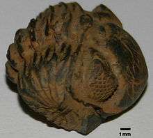
There are numerous marine fossils found in the Mahantango including Brachiopods, Crinoids, Trilobites, Bivalves, and Bryozoans.
Age
Relative age dating of the Mahantango places it in the Middle Devonian period, being deposited between 392 and 385 (±3) million years ago. It rests conformably atop the Marcellus Formation shale. Its upper contact is also conformable to the Trimmers Rock Formation and Harrell Shale.[8]
See also
References
- 1 2 "Explanation of Geologic Units" (PDF). Pennsylvania Geological Survey. Retrieved 2008-01-26.
- ↑ Conlin, Richard R.; Hoskins, Donald M. Geologic Map of the Mifflintown Qd. (Map). 1:24,000. Cartography by United States Geological Survey. Pennsylvania Geological Survey, Fourth Series. A126.
- ↑ Berg, T.M., Edmunds, W.E., Geyer, A.R. and others, compilers, (1980). Geologic Map of Pennsylvania: Pennsylvania Geologic Survey, Map 1, scale 1:250,000.
- 1 2 3 Milici, Robert C.; Swezey, Christopher S. (2006). "Assessment of Appalachian Basin Oil and Gas Resources: Devonian Shale–Middle and Upper Paleozoic Total Petroleum System" (PDF). United States Geological Survey. Retrieved 2008-04-05.
- ↑ MacLachlan, D.B., Hoskins, D.M., Payne, D.F., (1995). Bedrock Geology of the Freeburg 7.5 minuet Quadrangle, Snyder County, Pennsylvania. ORF 95-04, The Pennsylvania Geologic Survey, Harrisburg, PA.
- ↑ "Paleozoic Stratigraphic Column of Central Pennsylvania" (pdf). Bucknell University. Retrieved 2008-05-26.
- ↑ Prave, A.R., Duke, W.L., Slattery, W. (1996). A depositional model for storm- and tide-dominated prograding siliciclastic shorelines from the Middle Devonian of the central Appalachian foreland basin, USA. Sedimentology, 43, 611-629.
- ↑ Berg, T.M., et al., (1983). Stratigraphic Correlation Chart of Pennsylvania: G75, Pennsylvania Geologic Survey, Harrisburg, Pennsylvania.
External links
| Wikimedia Commons has media related to Mahantango Formation. |