Magic Roundabout (Swindon)
| Magic Roundabout | |
|---|---|
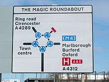 Sign approaching the Magic Roundabout from the south on the B4289 | |
| Location | |
| Swindon, England | |
| Coordinates: | 51°33′46.2″N 01°46′17.3″W / 51.562833°N 1.771472°WCoordinates: 51°33′46.2″N 01°46′17.3″W / 51.562833°N 1.771472°W |
| Roads at junction: |
Fleming Way Drove Road Shrivenham Road |
| Construction | |
| Type: | Roundabout |
| Constructed: | 1972[1] |
| Map | |
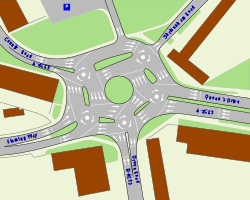 | |
The Magic Roundabout in Swindon, England, was constructed in 1972[1] and consists of five mini-roundabouts arranged around a sixth central, anti-clockwise roundabout. Located near the County Ground, home of Swindon Town F.C., its name comes from the popular children's television series The Magic Roundabout. In 2009 it was voted the fourth scariest junction in Britain, in a poll by Britannia Rescue.[2]
History
Concept
The roundabout was constructed according to the design of Frank Blackmore,[3] of the British Transport and Road Research Laboratory. Traffic flow around the larger, inner roundabout is anticlockwise, and traffic flows in the usual clockwise manner around the five mini-roundabouts and the outer loop.
The roundabout
The complex junction offers multiple paths between feeder roads. The outer circle carries traffic in a clockwise direction, like a normal roundabout (in places where traffic drives on the left hand side of the road), and less proficient users may choose to use only the outer circle. The inner circle carries traffic in a counterclockwise direction, and more proficient users may choose to use the alternative paths.[4]
Virtually the same overall configuration has been in place for 44 years.
When the roundabout complex was first opened, the mini-roundabouts were not permanently marked out and could be reconfigured while the layout was fine tuned. A police officer was stationed at each mini roundabout during this pilot phase to oversee how drivers coped with the unique arrangement.
The roundabout is built over a section of the old Wilts and Berks Canal – Swindon wharf. A narrow, stone bridge built c. 1810, which is a grade II listed building,[5] carried the old Saxon way known as Drove Road over the canal half a mile east of the town centre. Its site became covered by Drove Roundabout, which was later redeveloped as the Magic Roundabout. A wharf occupied one edge and the area was known as The Marsh. The Wilts and Berks Canal Trust are currently in negotiations with Swindon Council to include in the New Swindon Regeneration Framework plans to restore the canal through the town centre. The restoration would utilise the route of the North Wilts Canal and not the main West Vale route that the Magic Roundabout sits over. The North Wilts Canal was a separate branch which exited the town northwards through Moredon.

A calendar is produced each year by the UK Roundabout Appreciation Society depicting the town's finest examples.
The official name of the roundabout used to be County Islands, but it was changed in the late 1980s to match its popular name. It inspired the song "English Roundabout", a pop song by the Swindon band XTC, which was recorded for their 1982 album English Settlement. It is believed that young Australian veterinarians working in Swindon in the mid 1980s popularised the term after one of their cohort, Miss Peters (a notoriously poor driver) continually struggled with its "magic".
In 2005, it was voted the worst roundabout in a survey by a UK insurance company.[6] In September 2007, the Magic Roundabout was named as one of the World's Worst Junctions by a UK motoring magazine.[7] In December 2007, BBC News reported a survey identifying The Magic Roundabout as one of the "10 Scariest Junctions in the United Kingdom";[8] however, the roundabout provides a better throughput of traffic than other designs and has an excellent safety record, since traffic moves too slowly to do serious damage in the event of a collision.[9]
In 2010, the National Cooperative Highway Research Program concluded that the roundabout reduces injurious crashes by three quarters.[10][11]
The roundabout in Drove Bridge hasn't been the only Magic Roundabout in Swindon; the roundabout at Bruce Street Bridges was until recently a Magic Roundabout. It was converted into a conventional roundabout in 2016,[12] but with many exceptions to highway code priorities, which compromised safety. As a result, it is now planned to be converted back.[13]
British YouTuber Tom Scott made a video where he talks about the roundabout and explains why there haven't been any accidents there. He filmed at the roundabout itself.
See also
- Magic Roundabout (Colchester)
- Magic Roundabout (Hemel Hempstead)
- Magic Roundabout (High Wycombe)
- Denham Roundabout
References
- 1 2 "Swindon's 'iconic' Magic Roundabout turns 40". BBC News. 26 September 2012. Retrieved 9 June 2014.
- ↑ "Britain's scariest roads revealed". BBC News. 27 November 2009. Retrieved 27 November 2009.
- ↑ "Frank Blackmore: traffic engineer and inventor of the mini-roundabout". The Times. London. 14 June 2008. Retrieved 15 June 2008.
- ↑ "A counterflow roundabout". Archived from the original on 2014-03-01.
Tourists should follow the red path; keep in the Outer Circle all the way round and leave the yellow "Pro Driver Path" to the locals, who have roundabouts in their blood and know where they are going.
- ↑ "Canal Bridge, 300m north-east of the County, or Magic Roundabout". Images of England. Retrieved 27 November 2006.
- ↑ Brits vote on the best and worst roundabouts, 20 December 2005, retrieved 18 January 2008
- ↑ Worst 10 Junctions in the World
- ↑ 10 Scariest Junctions in the UK
- ↑ "The Magic Roundabout". CBRD. Retrieved 14 September 2016.
- ↑ Marshall, Aarian The Brilliant Sorcery of England’s 7-Circle Magic Roundabout Wired. August 3, 2016
- ↑ NCHRP Report 672 - Roundabouts: An Informational Guide U.S. Department of Transportation, Federal Highway Commission. August 3, 2016
- ↑ http://www.swindon.gov.uk/info/20031/roads_parking_and_transport/499/great_western_way_highway_improvements/2
- ↑ http://www.swindonadvertiser.co.uk/news/14326884.Drivers_speak_of_confusion_over_new_Bruce_Street_Bridges_road_layout/
External links
| Wikimedia Commons has media related to: |
- The Magic Roundabout at CBRD (Chris's British Road Directory)
- BBC Wiltshire Video: 1972 Points
- Magic Roundabout Show Web Site for the TV Show Magic Roundabout
- BBC Wiltshire History of the Magic Roundabout
- Driving over the Magic Roundabout video on YouTube
- Magic Roundabout, Swindon Web
- The Magic Roundabout at Swindon
- GPS Drawing tour around Magic Roundabout
- Google Maps satellite image view