Maghera
| Maghera | |
| Irish: Machaire Rátha | |
 Maghera Town Centre |
|
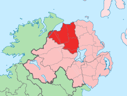
 Maghera |
|
| Population | 3,711 (2001 Census) |
|---|---|
| District | Mid-Ulster |
| County | County Londonderry |
| Country | Northern Ireland |
| Sovereign state | United Kingdom |
| Post town | MAGHERA |
| Postcode district | BT46 |
| Dialling code | 028 |
| Police | Northern Ireland |
| Fire | Northern Ireland |
| Ambulance | Northern Ireland |
| EU Parliament | Northern Ireland |
| UK Parliament | Mid Ulster |
| NI Assembly | Mid Ulster |
|
|
Coordinates: 54°50′38″N 6°40′23″W / 54.844°N 6.673°W
Maghera (pronounced /ˌmɑːhəˈrɑː/ MAH-hə-RAH, from Irish: Machaire Rátha, meaning "plain of the ringfort") is a town in County Londonderry, Northern Ireland. Its population was 2,876 in 1991 and had risen to 3,711 in the 2001 Census. It is situated within Mid-Ulster District, as well as the civil parish of Maghera, which it was named after, and the former barony of Loughinsholin.
History
The Annals of Ulster say that the seat of the Cenél nEoghain was at Ráth Luraig in Maghera.
On 12 July 1830, Orange Order marches led to clashes between Orangemen and Ribbonmen in Maghera and Castledawson. Several Catholic homes were then burnt by Protestants following these clashes.[1]
The Troubles
Maghera suffered significant violence during the Troubles. In total, 14 people were killed, half of them members of the security forces and a further two as a result of family membership of the Ulster Defence Regiment. The Provisional Irish Republican Army were responsible for ten of the deaths.
Demography
Maghera is classified as an intermediate settlement by the NI Statistics and Research Agency (NISRA) (i.e. with population between 2,250 and 4,500 people). On Census day (29 April 2001) there were 3,711 people living in Maghera. Of these:
- 28.6% were aged under 16 years and 13.3% were aged 60 and over
- 49.3% of the population were male and 50.7% were female
- 72.4% were from a Catholic background and 27.1% were from a Protestant background
- 3.9% of people aged 16–74 were unemployed.
For more details see: NI Neighbourhood Information Service
Places of interest
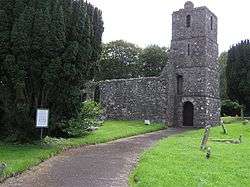
Notable buildings in Maghera include St Lurach's Church, which was founded in the year 500AD, originally as a monastery. The town of Maghera grew up around this church. The importance of the monastery was such that Maghera was a bishop's seat in the 12th and 13th centuries.[2] However, the Church was raided by the Vikings and fell into disrepair and is now maintained by the Environmental Heritage Service. Within the ruins, as an inset to the west wall is a sculpture of the crucifixion, which is thought to date from the 10th century – making it one of earliest surviving representations of the crucifixion in Ireland. St Lurach is also the saint of the town.[3]
Transport
Maghera railway station opened on 18 December 1880, shut for passenger traffic on 28 August 1950 and shut altogether on 1 October 1959.[4]

People from Maghera
- Charles Thomson, who emigrated to the United States where he became secretary of the Continental Congress, was from Maghera.
- Children's author Eve Bunting was born in Maghera; she later emigrated to the United States.
- Robert Hawthorne who won a Victoria Cross during the Indian Mutiny was from Maghera.
- Dr Henry Cooke, a noted theologian, was born at Maghera.
- James Lenox-Conyngham Chichester-Clark and his grandfather, James Johnston Clark, both MPs for County Londonderry, were born at Largantogher House.
- William Shiels (3 December 1848 – 17 December 1904), Australian colonial politician and 16th Premier of Victoria, was born at Maghera.
Churches
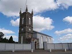
In St Patrick's Roman Catholic church there is a headstone remembering the large number of people who died in the parish during the Famine. In the local Church of Ireland parish of St. Lurach's there is a large inscribed bronze plate dedicated to the memory of the local men and women who died in the Great War. The town also has a Presbyterian church.
Schools
There are three primary and one secondary school in Maghera.
Primary schools
- St Mary's Primary School, Glenview
- Maghera Controlled Primary School
- St Patrick's Primary School, Glen
Secondary school
- St. Patrick's College, a co-educational college.
Former secondary school
- Maghera High School, which had an intake mainly from the local Protestant population, was shut in 2009 after a lengthy campaign by many locals to save it. Most of the remaining pupils were transferred to nearby Magherafelt High School.
Sport
- The local Gaelic football club is Watty Graham's Gaelic Athletic Club.
- The local soccer team is Maghera Strollers F.C.
- The nearest golf driving range is at Tobermore.
- The local leisure centre is Maghera Leisure Centre, on the Coleraine Road.
- The local Cycling Club is Carn Wheelers
- The local Cricket Club is Maghera Cricket Club.
References
- ↑ "Parades and Marches – Chronology 2: Historical Dates and Events". Conflict Archive on the Internet. Retrieved 28 January 2010.
- ↑ TG4 documentary
- ↑ TG4 documentary
- ↑ "Maghera station" (PDF). Railscot – Irish Railways. Retrieved 28 September 2011.
External links
| Wikimedia Commons has media related to Maghera. |