Magdalena Contreras

La Magdalena Contreras (Spanish pronunciation: [maɣðaˈlena konˈtɾeɾas]) is one of the 16 delegaciones (boroughs) into which Mexico's Federal District is divided. It had a 2010 census population of 239,086 inhabitants, and is the third-least populous of Mexico City's boroughs. It lies at an elevation of 2,365 m. above sea level.[1] It is named after two historically important communities, La Magdalena Atlitic, one of four communities with pre Hispanic roots, and Colonia Contreras, an area noted for its textiles mills until the 20th century. The northern end of the borough is urbanized with the rest, with its mountains and ravines, designated as a conservation zone. However, urban sprawl is putting pressure on these areas, with the borough government promoting ecotourism as a way to preserve the area’s forests and other natural resources. The largest ecotourism park is Los Dinamos, canyons and ravines cut by streams and fresh water springs which eventually form the Río Magdalena, Mexico City’s only remaining free flowing river.
History

The borough takes its name from the La Magdalena Atlitic and the Contreras neighborhood.[2]
Human settlements in the area date to between 500 and 200 years C.E., or the latter Pre Classic period. These settlements were mostly located in the Contreras area, and were under the control of Cuicuilco .[3][4] After Cuicuilco was destroyed by an eruption the higher elevations of this area was dominated by the Otomi and the Chichimecas, who together were known as the Nahuatlacas, a hunting-gathering society. The Tepanecs eventually came to dominate the area, making it part of the Coyoacán dominion. With the rise of the Aztecs, the Tepanecs were conquered and the name Atlitic "stone that drinks water" was given to the area, named after a large rock which rose above a small lake.[3] Four settlements date from the pre Hispanic period, San Bernabé Ocotepec, San Nicolás Totolapan, La Magdalena Atlitic and San Jeronimo Aculco.[4]

After the Spanish conquest of the Aztec Empire, the area was under the authority of the Dominicans, who established a town and church dedicated to Mary Magdalene, changing the name of the area to Magdalena (de) Atlitic. In 1543, Jerónimo de León established the first water-powered machinery here to create a saw mill, the first to take advantage of the waters of the Río Magdalena.[3] The Contreras family established a factory in the location that bears their name in the 17th century.[5] At the end of the 18th century, a group of Spanish industrialists founded a textile factory, which caused the economy and population to rise.[3] By the end of the 19th century, the river was powering four textile factories called El Águila Mexicana, Tizapán, Santa Teresa and Loreto.[3] These factories produced wool, cotton and cashmere thread and cloth of various types and by the end of the century, had the use of the Mexico City-Cuernavaca rail line for shipping.[5] However, from the colonial period through most of the 19th century, the area was poor, and populated by farm and textile laborers.[4]
The modern borough has its origins in the reorganizations of the Federal District of Mexico City at the beginning of the 20th century. There were several reorganizations from a former municipality system, settling to the current formation in 1927, by presidential decree.[6]
At the end beginning of the 20th century, there was a power struggle as part of the Mexican Revolution with the establishment of the Club Democrático Antireelectionista Vicente Guerrero formed in 1911 to fight against the power of local strongmen.[4]
The Mexico City-Cuernavaca rail line continued to operate through most of the 20th century, with a train called the "501" noted for carrying famous passengers between the two destinations. The line was officially shut down in 1997. The Contreras station was converted into a park.[4][5]
The latter 20th century is marked by population growth, especially in the borough’s north end. In 1963, an extension of the Anillo Periférico ring road was constructed through the borough, prompting the development of housing projects for the city’s growing population starting in the 1970s. These developments include Santa Teresa, Pedregal II, Pueblo Nuevo, Potrerillo, El Rosal, El Tanque and El Toro, heading west from the roadway.[3] In 1900, the area was completely rural, with a population of only 8,150 people, most in the town of La Magdalena. It began growing starting in the 1940s to just over 40,000 in 1960, but from then until 1990 the population reached over 195,000. Population growth continues but at a slower pace: 222,000 by 2000 and 229,000 in 2005.[4][7] There is limited space for housing projects due to the geography of the area, but population growth has prompted illegal settlements in conservation areas and even in steep ravines where landslides are a danger.[3][4]
Geography and environment

Magdalena Contreras is one of Federal District of Mexico City’s sixteen boroughs, located in the southwest of this entity. It is bordered by the boroughs of Álvaro Obregón and Tlalpan, with the State of Mexico to the west.[6] It has a territory of 7,458.43 hectares or 62.2km2, accounting for 5.1% of the Federal District.[4][6] It has an average altitude of 2,510 meters above sea level. The borough is divided into forty seven official neighborhoods called colonias.[4] The oldest of these are La Magdalena Contrereas, San Jerónimo Aculco, San Bernabé Ocotepec and San Nicolás Totolapan.[6]
The territory is located in the southwest of the Valley of Mexico, along the lower eastern slopes of the Sierra de las Cruces, a volcanic mountain range.[6] The geography of the borough stretches from foothills to lower mountains of the range, which are separated by ravines and canyons.[6] Major elevations include Cerro Panza (3,600), Nezehuiloya (3,760), Pico Acoconetla (3,400), Cerro Palmitas (3,700), Cerro Palmas (3,789), Piedras Encimadas (3,200), El Aguajito (2,350), Tarumba (3,470), Cerro del Judío (2,770), Cerro Sasacapa (3,250) and Cerro San Miguel (3,630) .[6] Principle canyons and ravines include Tlalpuente, Cainotitas, Atzoma and Tejocote, located in the center of the borough.[4]
.jpg)
The ravines and canyons are carved by streams and run off from freshwater springs. Some of these flow year round and others only during the summer rainy season. The most important springs are Pericos, Mal Paso, Apapxtla, Las Ventanas, Cieneguillas, Los Cuervos and San Miguel. There are two major flows of water the Río Magdalena and the Río Eslava.[6] The Río Magdalena is the only still free flowing river in the Federal District. It begins on the slopes of the Cerro La Palma, in the Cuajimalpa borough. Some of the water is captured at a section of the Los Dinamos park to be treated at a plant, but the rest flows down to the floor of the Valley.[4][6] The borough has little in the way of structured drainage of wastewater and rainwater. Much wastewater flows openly, which has contaminated local streams and the Río Magdalena. The problem is serious enough in the urbanized area to affect the population’s health, as the wastewater affects the supply of drinking water.[8]
There are three main climates found in the borough. The urbanized part is temperate and semi moist. Conservation areas between 2,900 and 3,500 meters above sea level are semi-cold and semi moist and those areas above 3,700 have a semi-cold and moist. All areas receive most of their rainfall during the summer rainy season, especially in July. This precipitation can often take the form of hail, with fog common as well in both summer and in November and December, but snow is rare.[4][6]
| Monte Alegre | ||||||||||||||||||||||||||||||||||||||||||||||||||||||||||||
|---|---|---|---|---|---|---|---|---|---|---|---|---|---|---|---|---|---|---|---|---|---|---|---|---|---|---|---|---|---|---|---|---|---|---|---|---|---|---|---|---|---|---|---|---|---|---|---|---|---|---|---|---|---|---|---|---|---|---|---|---|
| Climate chart (explanation) | ||||||||||||||||||||||||||||||||||||||||||||||||||||||||||||
| ||||||||||||||||||||||||||||||||||||||||||||||||||||||||||||
| ||||||||||||||||||||||||||||||||||||||||||||||||||||||||||||
Wildlife and native flora are mostly restricted to the southern two thirds of the borough where the conservation areas are.[4] The vegetation of this conservation area is an important source for oxygenation in the Valley of Mexico.[3] Vegetation varies by altitude. Tree species include oaks, holm oaks and pines. Bushes, brush and other vegetation is mostly deciduous as well as plants from the legume and cactus families. A number of ravines and some of the higher altitudes have species adapted to wetter climes including Alnus jorullensis, Salix bonpladiana, Fraxinus uhdei, Buddlei cordata, Pronus capuli and Taxodium mucronatum. In the pre Hispanic period, fauna was highly varied; however, most of these species such as wildcats, wolves, coyotes, anteaters and many others are no longer found, having been forced out by human settlement and habitat loss. Smaller mammals such as rabbits and squirrels still remain, especially in the higher elevations. Also remaining are various types of birds such as hummingbirds, carpenter birds and more, along with various lizards, snakes and amphibians.[6]
The borough has important ecological and tourist centers but these are facing degradation from urban sprawl .[3][8] The territory is 73% under conservation, with 18% regularized urban space. Three and a half percent has illegal settlements.[4] The illegal settlements are the most problematic for the borough, with most environment damage occurring in or near them. One significant problem is the illegal construction of residences on the steep slopes of ravines, for both environmental and safety reasons. The illegal settlements have also generation a large number of illegal dumps of solid and liquid waste, especially in ravines, which pollute the water supply.[8] Many of these settlements are built on steep slopes in or near ravines. The borough states that there are 106 areas of construction, about 1,000 residences, at high risk of landslides during the rainy season.[9][10] Efforts to combat these problems include relocating those in illegal residences and developing ecotourism and other programs with those who own still rural areas of the borough.[8]
Socioeconomics and culture
The borough is mostly residential in the northern third and mostly rural agricultural and conservation area in the south. The major population centers are found in the lower elevations in the central section of the borough.[6]
For both environmental and economic reasons, ecotourism is an important aspect of the borough economy.[11] The borough government has promoted this development, especially over the past twenty years, encouraging major landholders to develop ecotourism parks and other measures.[4] It established a tourism corridor, mostly focused on the older communities and natural areas.[12] Magdalena Atlitic was declared a Barrio Magico, with a "tourism market" located just outside the entrance to Los Dinamos.[5][13] It is also the site of the Feria de la Trucha y la Quesadilla (Trout and Quesadilla Fair) established in 2010, to encourage the area’s reputation for ecology. In addition to trout and quesadillas, the event also has pulque, music, dance, and exhibitions of agriculture, handcrafts and other products.[13][14]
The borough now has several major ecotourism areas. The largest of these is Los Dinamos Park, part of the Bosques de la Cañada de Contreras conservation area. It has an area of 2,429 hectares that encompass a series of canyons formed by streams that eventually empty in the Río Magdalena. The longest of these canyons is twelve meters. The park has over twenty six km of hiking paths which connect with those of San Nicolás Totolapan as well as some vertical canyon slopes for climbing. There are also waterfalls up to 3.5 meters high as clean fresh water springs. The park also contains the remains of several former textile factories which ran on hydroelectricity.[11] The Los Dinamos park contains 2,392 hectares. The park receives about 3,000 visitors a week.[2]

The ejido of San Nicolás Totolapan has two main ecotourism areas, one called the Parque Ecoturístico and the other called Valle de Monte Alegre with a total area of 1,700 hectares. These offer restaurant services, campgrounds, horseback riding, rock climbing, ATV rentals, hiking, sports fishing and more. It also has a large rainbow trout farm. The ejido is located in the south of the borough, on the northwest slope of the Ajusco Volcano.[2][11] The San Bernabé Ocotepec Ecotourism Park is located on the Cajetes and Meyuca mountains next to the community of the same name. It has 337.1 hectares of pine and oyamel fir forests, established in 1998 to block the advance of urban sprawl. It has rock climbing, camping, picnicking and a lookout point over Mexico City.[2][11] The Mazatepetl Eco-archeological Park is located on the San Bernabé Ocotepec ejido on a large hill called Cerro del Judío. It contains a restored pyramid at the top of the hill originally constructed between 1200 and 1380 by the Otomi. Mazatepetl is one of oldest stone constructions in the Valley of Mexico.[2][11] The El Potrero Ecological Park is located in Los Dinamos at an area called Llano de Acopilco. It has rappelling, hiking, camping, archery and cabins.[11]
Some of the area’s rural character is still preserved in the observances of religious festivals. The day of the Cross (May 3) is a popular festival in the borough, especially in the La Cruz neighborhood and the Cerro de Judío. During Holy Week, the custom of erecting altars in honor of the Virgin of Sorrows is still observed. There is a traditional passion play depicting the passion and crucifixion of Christ during the week, with the main event on Good Friday at the Cerro de Judío.[15] A newer one is held at Los Dinamos by a youth experimental theatrical group called Vivanco.[16] In addition, it is traditional to spend Holy Saturday at Los Dinamos.[15] Holy Week events have drawn up to 80,000 spectators for both the events and holidays at Los Dinamos.[16] In addition, the area has a major annual pilgrimage to Chalma during this week.[15] Another major traditional observance is Day of the Dead .[15] These observances have drawn up to 90,000 people to the borough, mostly to the cemeteries of San Bernabé, San Jerónimo and San Francisco.[17]
Communities

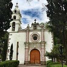
The four oldest communities in the borough are La Magdalena Atlitic, San Nicolás Totolapan, San Jerónimo Aculco and San Barnabé Ocotepec, all of pre Hispanic origin. The modern community of La Magdalena Atlitic is centered on a church which was founded in the 16th century as a hermitage.[5][18] The current structure dates to 1760. In 1932, it was named a national monument. The church has a Baroque facade with raised patterns, fronted by a stone paved atrium with has a fountain with an image of the Archangel Michael. The main portal is flanked by Doric pilasters holding up an arch and a cornice to the choir window.[18] At the base of the arches over the main altar inside, there are feather designs, unique in Mexico.[5]

The town of San Nicolás Totolapan is centered on the Plaza Cívica Benito Juárez.[19] Its church was founded in 1535 over a former pre Hispanic ceremonial center during evangelization dedicated to Saint Nicholas. It has as simple facade and a Baroque bell tower, surrounded by gardens that contains a stone with inscriptions.[18] San Jerónimo Aculco has a plaza called the Plaza Cívica Lidice, named after a Czech town attacked the Nazis in 1942. It contains a Rosedal de Paz (Rose Garden of Peace) and mural called "Campos de Luz y Muerte" (Fields of Light and Death) by Ariosto Otero.[19] The town of San Jerónimo Aculco dates back to the Toltec period. Its church was built in the 16th century by the Franciscans and maintains its open chapel and original baptismal font. Its facade is Baroque with sculpted sandstone. Its atrium cross dates to the 18th century. Its interior was redone in 1971. The San Baranbé Ocotepec church was built in the 16th century as part of evangelization efforts and dedicated to Barnabas. Its main altar is Baroque and there are archeological remains in its atrium.[18]
History and population growth have led to other communities being established in the area. In the colonial period up until the 19th century, the main industry here was textiles, with factories taking advantage of power generated by rivers and springs here. One major area for these factories is the area now known as Colonia Contreras. The grounds of the former El Águila textile mill are now the Foro Cultural (Cultural Forum), inauguraged in 1979. Remains of the mill’s installations, such as its smokestack still remain, but it is now a wooded area with an auditorium, gallery, offices, workshops and libraries.[5][20] Near the Foro is the Purísima Concepción Church. It was founded in the 16th century, but the current structure was built in the 17th by the Contreras family, owners of the El Águila mill and offered masses to textile workers.[18] It was the original home of the Señor de Contreras, property of Tomás de Contreras, to which miracles have been attributed. The life-sized wood carving today is found at the former El Carmen monastery in San Ángel .[4] The stone faced building attached to the church was the former residence of the Contreras hacienda today it is the Casa de Bellas Artes (Fine Arts House) which offers classes in dance, painting, music and more. Juventino Rosas stayed here and composed a waltz called Sobre las olas.[5][18] The area’s former rail station, Estación Ferrocarril de Cuernavaca, is now a park. It contains a large mural by Ariosto Otero called El viaje del siglo veinte (Voyage of the 20th Century) which features the "501" train, which carried famous passengers such as Diego Rivera, Tin Tan and Lilia Prado.[5]
Although named for the Magdalena and Contreras areas, the borough’s main institutions are in Colonial Barranca Seca. These include the civic plaza, the municipal building and the Centro Cultural La Magdalena Contreras, which is in a former movie theater from the 1940s.[18][19] Other notable modern communities include the Unidad Habitacional de Servicios Sociales, which was opened in 1960,[19] Ampliación Lomas de San Bernabé, El Tanque and La Malinche.[4]
Education
Public high schools of the Instituto de Educación Media Superior del Distrito Federal (IEMS) include:[21]
- Escuela Preparatoria Magdalena Contreras "Ignacio Manuel Altamirano"
Private schools:
- Colegio Williams Campus San Jerónimo[22]
- Green Hills School South Campus[23]
- Vermont School Plantel San Jerónimo[24][25]
References
- ↑ 2010 census tables: INEGI
- 1 2 3 4 5 "Magdalena Contreras" (in Spanish). Mexico City: Secretaria de Turismo, Distrito Federal. Retrieved July 10, 2013.
- 1 2 3 4 5 6 7 8 9 "Historia" [History] (in Spanish). Mexico City: Borough of Magdalena Contreras. Retrieved July 10, 2013.
- 1 2 3 4 5 6 7 8 9 10 11 12 13 14 15 16 17 "La Magdalena Contreras". Enciclopedia de Los Municipios y Delegaciones de México Distrito Federal (in Spanish). Mexico: INAFED. 2010. Retrieved July 10, 2013.
- 1 2 3 4 5 6 7 8 9 "Santa María Magdalena Atlitic" (in Spanish). Mexico City: Mexico Desconocido magazine. Retrieved July 10, 2013.
- 1 2 3 4 5 6 7 8 9 10 11 12 "Geografía" [Geography] (in Spanish). Mexico City: Borough of Magdalena Contreras. Retrieved July 10, 2013.
- ↑ "Demografía" [Demographics] (in Spanish). Mexico City: Borough of Magdalena Contreras. Retrieved July 10, 2013.
- 1 2 3 4 "Problemática Ambiental" [Environmental Problems] (in Spanish). Mexico City: Borough of Magdalena Contreras. Retrieved July 10, 2013.
- ↑ "Detectan 106 puntos de riesgo por deslaves en Contreras" [Detect 106 risk areas for landslides in Contreras] (in Spanish). Mexico City: El Universal. April 9, 2013. Retrieved July 10, 2013.
- ↑ "Lluvias afectan 1,000 viviendas en Magdalena Contreras" [Rains affect 1,000 residences in Magdalena Contreras] (in Spanish). Mexico City: El Financiero. June 10, 2013. Retrieved July 10, 2013.
- 1 2 3 4 5 6 "Ecoturismo" [Ecotourism] (in Spanish). Mexico City: Borough of Magdalena Contreras. Retrieved July 10, 2013.
- ↑ "Contará Magdalena Contreras con un Barrio Mágico" [Magdalena Contreras will have a Magical Neighborhood] (in Spanish). Mexico City: NOTIMEX. July 8, 2011.
- 1 2 "Magdalena Contreras, se convertirá en un polo turístico a nivel nacional e internacional" [Magdalena Contreras, will convert into a national and international tourist attraction] (in Spanish). Mexico City: Diario Crítico. March 26, 2013. Retrieved July 10, 2013.
- ↑ "La delegación Magdalena Contreras inició en la Cañada de Contreras,... [Derived headline]" [Magdalena Contreras borough began in the Contreras Canyon] (in Spanish). Mexico City: NOTIMEX. March 26, 2010.
- 1 2 3 4 "Festividades" [Festivities] (in Spanish). Mexico City: Borough of Magdalena Contreras. Retrieved July 10, 2013.
- 1 2 "Escenificarán dos Vía-Crucis en la delegación Magdalena Contreras" [Will have two passion plays in the Magdalena Contreras borough] (in Spanish). Mexico City: NOTIMEX. March 28, 2009.
- ↑ "Atenderá La Magdalena Contreras a 90 mil personas por Día de Muertos." [90,000 people will visite Magalena Contreras for Day of the Dead] (in Spanish). Mexico City: NOTIMEX. October 19, 2008.
- 1 2 3 4 5 6 7 "Iglesias Representativas" [Representative Churches] (in Spanish). Mexico City: Borough of Magdalena Contreras. Retrieved July 10, 2013.
- 1 2 3 4 "Plazas Civicas" [Town squares] (in Spanish). Mexico City: Borough of Magdalena Contreras. Retrieved July 10, 2013.
- ↑ "Centros culturales" [Cultural centers] (in Spanish). Mexico City: Borough of Magdalena Contreras. Retrieved July 10, 2013.
- ↑ "Planteles Magdalena Contreras." Instituto de Educación Media Superior del Distrito Federal. Retrieved on May 28, 2014.
- ↑ "CAMPUS." Colegio Williams. Retrieved on April 15, 2016. "Campus San Jerónimo Presa Reventada No. 53 Col. San Jerónimo Lídice Deleg. La Magdalena Contreras México D.F., C.P. 10400"
- ↑ "Planteles." Green Hills School. Retrieved on April 18, 2016. "Plantel Sur - San Jerónimo Dirección: Av. San Bernabé No. 960 Col. San Jerónimo Lídice México D.F. C.P. 10200 "
- ↑ Home page. Vermont School. Retrieved on April 18, 2016. "Plantel San Jerónimo Secundaria y Preparatoria[...]Av. San Francisco 109 San Jerónimo C.P. 10500, México D.F."
- ↑ Catalogo de Instituciones Con Estudios Incorporados a la Unam 2005-2006. Autonomous University of Mexico. p. 202.
External links
- (Spanish) Delegación Magdalena Contreras Official site
Coordinates: 19°20′00″N 99°12′50″W / 19.33333°N 99.21389°W