Madisonville, Tennessee
| Madisonville, Tennessee | |
|---|---|
| City | |
|
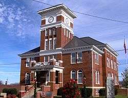
Monroe County Courthouse in Madisonville | |
 Madisonville, Tennessee Location within the state of Tennessee | |
| Coordinates: 35°31′14″N 84°21′46″W / 35.52056°N 84.36278°WCoordinates: 35°31′14″N 84°21′46″W / 35.52056°N 84.36278°W | |
| Country | United States |
| State | Tennessee |
| County | Monroe |
| Founded | 1822[1] |
| Incorporated | 1866[2] |
| Named for | James Madison |
| Area | |
| • Total | 5.8 sq mi (15 km2) |
| • Land | 5.8 sq mi (15 km2) |
| • Water | 0.0 sq mi (0 km2) |
| Elevation | 994 ft (303 m) |
| Population (2010) | |
| • Total | 4,577 |
| • Density | 677.4/sq mi (261.5/km2) |
| Time zone | Eastern (EST) (UTC-5) |
| • Summer (DST) | EDT (UTC-4) |
| ZIP code | 37354 |
| Area code(s) | 423 |
| FIPS code | 47-45320[3] |
| GNIS feature ID | 1326391[4] |
Madisonville is a city in and the county seat[5] of Monroe County, Tennessee, United States. The population was 3,939 at the 2000 census and 4,577 at the 2010 census. It is the location of Hiwassee College.
Geography
Madisonville is located at 35°31′11″N 84°21′49″W / 35.51972°N 84.36361°W (35.520691, -84.362905).[6] It is situated along U.S. Route 411 just east of its junction with State Route 68, near the center of Monroe County. The Unicoi Mountains rise prominently to the southeast.
According to the United States Census Bureau, Madisonville has a total area of 5.8 square miles (15 km2), all land.
Demographics

| Historical population | |||
|---|---|---|---|
| Census | Pop. | %± | |
| 1870 | 324 | — | |
| 1920 | 850 | — | |
| 1930 | 926 | 8.9% | |
| 1940 | 965 | 4.2% | |
| 1950 | 1,487 | 54.1% | |
| 1960 | 1,812 | 21.9% | |
| 1970 | 2,614 | 44.3% | |
| 1980 | 2,884 | 10.3% | |
| 1990 | 3,033 | 5.2% | |
| 2000 | 3,939 | 29.9% | |
| 2010 | 4,577 | 16.2% | |
| Est. 2015 | 4,783 | [7] | 4.5% |
| Sources:[8][9] | |||
As of the census[3] of 2000, there were 3,939 people, 1,671 households, and 1,066 families residing in the town. The population density was 677.4 people per square mile (261.3/km²). There were 1,806 housing units at an average density of 310.6 per square mile (119.8/km²). The racial makeup of the town was 93.42% White, 3.96% African American, 0.25% Native American, 0.33% Asian, 0.13% Pacific Islander, 0.79% from other races, and 1.12% from two or more races. Hispanic or Latino of any race were 2.01% of the population.
There were 1,671 households out of which 27.6% had children under the age of 18 living with them, 46.4% were married couples living together, 13.8% had a female householder with no husband present, and 36.2% were non-families. 32.0% of all households were made up of individuals and 12.9% had someone living alone who was 65 years of age or older. The average household size was 2.26 and the average family size was 2.86.
In the town the population was spread out with 23.0% under the age of 18, 9.6% from 18 to 24, 27.6% from 25 to 44, 22.6% from 45 to 64, and 17.2% who were 65 years of age or older. The median age was 36 years. For every 100 females there were 89.7 males. For every 100 females age 18 and over, there were 85.6 males.
The median income for a household in the town was $29,250, and the median income for a family was $31,918. Males had a median income of $31,504 versus $23,828 for females. The per capita income for the town was $16,468. About 13.3% of families and 18.8% of the population were below the poverty line, including 26.8% of those under age 18 and 14.0% of those age 65 or over.
History
The City of Madisonville originally began as the town of Tellico, and prior to that a Cherokee village of the same name. The Calhoun Treaty and resulting Hiwassee Purchase of 1819 opened the area for white settlement. Madisonville was founded in the early 1820s as a county seat for Monroe County, which had been formed in 1819. The town was initially known as "Tellico," but its name was changed to "Madisonville" in 1830 in honor of U.S. President James Madison in accordance with a petition from the residents presented by state representative James Madison Greenway.[10] Madisonville was incorporated on May 16, 1850.
Airport
The Monroe County Airport is a county-owned, public-use airport located two nautical miles (3.7 km) northwest of the central business district of Madisonville.[11]
Education
Hiwassee College is located just north of the Madisonville city limits. Madisonville is also home to a satellite campus of Cleveland State Community College.
The Monroe County Schools System serves Madisonville, they include:
- Madisonville Primary School,
- Madisonville Intermediate School,
- Madisonville Middle School
- Sequoyah High School.
Sequoyah was formed by the consolidation of Vonore High School and Madisonville High School in 1995.
Notable natives
- Isaac Cline - Meteorologist born nearby.
- Sue K. Hicks - Scopes Trial attorney and influence for the ballad, "A Boy Named Sue"
- Estes Kefauver - U.S. Congressman and Senator who ran for Vice President as Adlai Stevenson's running mate in 1956.
- Sharon Gail Lee - Tennessee Supreme Court Justice
- Tod Sloan - Major League Baseball Outfielder
- EmiSunshine - Singer / Songwriter
References
- ↑ Austin Foster, Counties of Tennessee (Genealogical Publishing Company, 2009), p. 30.
- ↑ Tennessee Blue Book, 2005-2006, pp. 618-625.
- 1 2 "American FactFinder". United States Census Bureau. Retrieved 2008-01-31.
- ↑ "US Board on Geographic Names". United States Geological Survey. 2007-10-25. Retrieved 2008-01-31.
- ↑ "Find a County". National Association of Counties. Retrieved 2011-06-07.
- ↑ "US Gazetteer files: 2010, 2000, and 1990". United States Census Bureau. 2011-02-12. Retrieved 2011-04-23.
- ↑ "Annual Estimates of the Resident Population for Incorporated Places: April 1, 2010 to July 1, 2015". Retrieved July 2, 2016.
- ↑ "Census of Population and Housing: Decennial Censuses". United States Census Bureau. Retrieved 2012-03-04.
- ↑ "Incorporated Places and Minor Civil Divisions Datasets: Subcounty Resident Population Estimates: April 1, 2010 to July 1, 2012". Population Estimates. U.S. Census Bureau. Retrieved 11 December 2013.
- ↑ "History of Madisonville." TNGenNet.org. Retrieved: 29 December 2007.
- ↑ FAA Airport Master Record for MNV (Form 5010 PDF). Federal Aviation Administration. Effective 8 April 2010.
External links
Municipalities and communities of Monroe County, Tennessee, United States | ||
|---|---|---|
| Cities | ||
| Towns | ||
| Unincorporated communities |
| |
| Footnotes | ‡This populated place also has portions in an adjacent county or counties | |