Macomb, Oklahoma
| Macomb, Oklahoma | |
|---|---|
| Town | |
| Nickname(s): "Queen City of South Pottawatomie County" [1] | |
 Location of Macomb, Oklahoma | |
| Coordinates: 35°8′52″N 97°0′30″W / 35.14778°N 97.00833°WCoordinates: 35°8′52″N 97°0′30″W / 35.14778°N 97.00833°W | |
| Country | United States |
| State | Oklahoma |
| County | Pottawatomie |
| Area | |
| • Total | 0.1 sq mi (0.2 km2) |
| • Land | 0.1 sq mi (0.2 km2) |
| • Water | 0.0 sq mi (0.0 km2) |
| Elevation | 1,001 ft (305 m) |
| Population (2010) | |
| • Total | 32 |
| • Density | 320/sq mi (160/km2) |
| Time zone | Central (CST) (UTC-6) |
| • Summer (DST) | CDT (UTC-5) |
| ZIP code | 74852 |
| Area code(s) | 405 |
| FIPS code | 40-45500[2] |
| GNIS feature ID | 1095077[3] |
Macomb is a town in Pottawatomie County, Oklahoma, United States. The population was 32 at the 2010 census. This was a decline of 47.5 percent from 61 at the 2000 census.[4]
History
The present town of Macomb began as a community named Burnett on the land allotment owned by on State Highway 59B. when the Atchison, Topeka and Santa Fe Railway Burnett, entrepreneurs from Burnett, moved to the current site. A post office, originally designated as McComb, opened at the new site on May 29, 1903. The post office and the town had been named for a Santa Fe engineer named Macomb. The names of the town and post office were changed to Macomb on July 16, 1915, to correct the spelling.[1]
By the end of 1904, the town newspaper, McComb Herald, claimed the population was 350 and coined the nickname, "Queen City of South Pottawatomie County." [1] The 1910 census reported a population of only 166. The 1920 census showed 281 residents. Hard times came when a prolonged drought caused the cotton crops to fail. In 1930, there were only 197 inhabitants. People moved away from the area; the 1950 census reported 123 residents. The number fell to 61 by the 2000 census.[1]
Geography
Macomb is located at 35°8′52″N 97°0′30″W / 35.14778°N 97.00833°W (35.147841, -97.008391).[5] It is 10 miles (16 km) southwest of Tecumseh on State Highway 59B.[1]
According to the United States Census Bureau, the town has a total area of 0.1 square miles (0.26 km2), all of it land.
Demographics
| Historical population | |||
|---|---|---|---|
| Census | Pop. | %± | |
| 1910 | 166 | — | |
| 1920 | 281 | 69.3% | |
| 1930 | 197 | −29.9% | |
| 1940 | 201 | 2.0% | |
| 1950 | 123 | −38.8% | |
| 1960 | 76 | −38.2% | |
| 1970 | 41 | −46.1% | |
| 1980 | 58 | 41.5% | |
| 1990 | 64 | 10.3% | |
| 2000 | 61 | −4.7% | |
| 2010 | 32 | −47.5% | |
| Est. 2015 | 33 | [6] | 3.1% |
As of the census[2] of 2000, there were 61 people, 26 households, and 20 families residing in the town. The population density was 610 people per square mile. There were 26 housing units at an average density of 294.3 per square mile (111.5/km²). The racial makeup of the town was 85.2% White, 1.6% African American, 9.8% from other races, and 3.3% from two or more races. Hispanic or Latino of any race were 9.8% of the population.
There were 20 households out of which 45.0% had children under the age of 18 living with them, 50.0% were married couples living together, 20.0% had a female householder with no husband present, and 15.0% were non-families. 10.0% of all households were made up of individuals and 5.0% had someone living alone who was 65 years of age or older. The average household size was 3.05 and the average family size was 3.18.
In the town the population was spread out with 31.1% under the age of 18, 4.9% from 18 to 24, 27.9% from 25 to 44, 24.6% from 45 to 64, and 11.5% who were 65 years of age or older. The median age was 31 years. For every 100 females there were 125.9 males. For every 100 females age 18 and over, there were 121.1 males.
The median income for a household in the town was $30,735, and the median income for a family was $34,583. Males had a median income of $25,000 versus $18,125 for females. The per capita income for the town was $15,006. There were 9.2% of families and 12.4% of the population living below the poverty line, including 37.5% of under eighteens and none of those over 64.
References
- 1 2 3 4 5 Bessie Cope, "Macomb." , Encyclopedia of Oklahoma History and Culture. Accessed May 23, 2015.
- 1 2 "American FactFinder". United States Census Bureau. Retrieved 2008-01-31.
- ↑ "US Board on Geographic Names". United States Geological Survey. 2007-10-25. Retrieved 2008-01-31.
- ↑ CensusViewer:Population of the City of Macomb, Oklahoma
- ↑ "US Gazetteer files: 2010, 2000, and 1990". United States Census Bureau. 2011-02-12. Retrieved 2011-04-23.
- ↑ "Annual Estimates of the Resident Population for Incorporated Places: April 1, 2010 to July 1, 2015". Retrieved July 2, 2016.
- ↑ "Census of Population and Housing". Census.gov. Retrieved June 4, 2015.
External links
Municipalities and communities of Pottawatomie County, Oklahoma, United States | ||
|---|---|---|
| Cities | 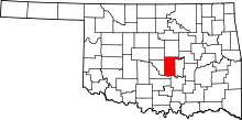 | |
| Towns | ||
| CDP | ||
| Other unincorporated communities |
| |
| Ghost towns | ||
| Footnotes | ‡This populated place also has portions in an adjacent county or counties | |