Macgregor, Australian Capital Territory
| Macgregor Canberra, Australian Capital Territory | |||||||||||||
|---|---|---|---|---|---|---|---|---|---|---|---|---|---|
 | |||||||||||||
| Population | 5,506 (2011 census)[1] | ||||||||||||
| • Density | 1,280/km2 (3,320/sq mi) | ||||||||||||
| Established | 1972 | ||||||||||||
| Postcode(s) | 2615 | ||||||||||||
| Area | 4.3 km2 (1.7 sq mi) | ||||||||||||
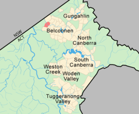
| District | Belconnen | ||||||||||||
| Territory electorate(s) | Ginninderra | ||||||||||||
| Federal Division(s) | Fenner | ||||||||||||
| |||||||||||||
Macgregor is a residential suburb in the Belconnen district of Canberra, located within the Australian Capital Territory, Australia. It was gazetted on 9 September 1971. It lies next to the suburbs of Dunlop, Latham and Holt on the western side of Belconnen, with Florey Drive the boundary to the east, Ginninderra Drive on the north, and Southern Cross Drive on the south.
The suburb of Macgregor is named after Sir William MacGregor, Governor of Queensland 1909-14 and first Chancellor of the University of Queensland, 1911. Streets are named after members of the Australian medical professions.[2]
Facilities and location
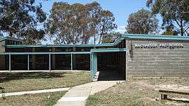
Macgregor has a primary school and neighbourhood oval. The main road in the suburb is Osburn Drive, which passes by a shop (formerly a pertrol station) and an area that was formerly a small shopping centre — this has now been demolished and redeveloped into Kings swimming pool.
Macgregor is primarily situated on Mount Goodwin (612 metres (2,008 ft)). Ginninderra Creek runs through the middle of the suburb for 1.4 kilometres (0.87 mi).
Political representation
For the purposes of Australian federal elections for the House of Representatives, Macgregor is in the Fenner.[3]
For the purposes of Australian Capital Territory elections for the ACT Legislative Assembly, Macgregor is in the Ginninderra electorate.[4]
Geology
Silurian age Deakin Volcanics purple rhyodacite covers the suburb.[5]
Gallery
-
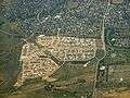
Aerial view from the west showing the new part.
-
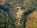
Sewage is handled nearby at the treatment works.
References
- ↑ Australian Bureau of Statistics (31 October 2012). "Macgregor (State Suburb)". 2011 Census QuickStats. Retrieved 24 January 2014.
- ↑ "Suburb Name search results". ACT Environment and Sustainable Development. Retrieved 11 February 2014.
- ↑ "Profile of the electoral division of Fenner (ACT)". Current federal electoral divisions. Australian Electoral Commission. 8 February 2016. Retrieved 29 May 2016.
- ↑ "Electorates 2012 election". Electorates. ACT Electoral Commission. 5 July 2012. Retrieved 17 December 2013.
- ↑ Henderson G A M and Matveev G, Geology of Canberra, Queanbeyan and Environs 1:50000 1980.
Coordinates: 35°12′39″S 149°00′55″E / 35.21083°S 149.01528°E