Maasland
| Maasland | |||
|---|---|---|---|
| Town | |||
|
Maasland | |||
| |||
 Maasland Location within the Netherlands | |||
| Coordinates: NL 51°56′7″N 4°16′10″E / 51.93528°N 4.26944°E | |||
| Country | Kingdom of the Netherlands | ||
| Constituent country |
| ||
| Province | South Holland | ||
| Municipality Gemeente | Midden-Delfland | ||
| Time zone | CET (UTC+1) | ||
| • Summer (DST) | CEST (UTC+2) | ||
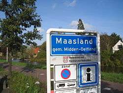


Maasland (population: 6,844) is a town in the western Netherlands, in the province of South Holland. It lies in the municipality (gemeente) of Midden-Delfland and covers an area of 24.42 km² (of which 0.64 km² water).
The first signs of a community started back in 925 when the area became part of the county of Graaf Dirk II and a church was built. After severe floodings during the 12th century, the Maasdijk was rebuilt and the town centre relocated to its current site. In 1241 the German Teutonic Knights drew on the territory of Maasland.
In 1450 the 'Poldermolen' (translation: Poldermill) was built in Maasland (see picture).
During the war between Spain and the Netherlands a huge area of the Netherlands was flooded which was part of the strategy of Willem van Oranje. In 1574, these floodings affected Maasland, and once again the town was flooded. It took a couple of years before the town was rebuilt and in 1614 part of the town Maasland (which included the Maeslandsluys) gained independency and is known as Maassluis.
Until the new townhall was built in 1874 meetings of the city council meetings were held in the tavern 'de Pynas'.
In the late 20th century the town of Maasland and its surrounding communities were governed as the municipality (gemeente) of Maasland, with most governmental functions based in the town.
In 2004, the town of Maasland became part of the municipality (gemeente) of Midden-Delfland upon the merger of the municipality of Maasland and the municipality of Schipluiden.[1]
Places of interest
- The 'Oude Kerk' (translation: Old Church (founded circa 1400), burned down during the celebrations for freedom after World War II. Restored in 1954.
- Tavern 'de Pynas', which is still a café.
- Museum 'de Schilpen', an eighty-year-old grocery store in its original state. Now a museum.
- The 'Two Mills'
In the News
- According to Elsevier (a Dutch magazine) Maasland was the wealthiest town in the Netherlands during 2004.
- In August 2004 the KNMI (Dutch institute for Weather forecasting) reported an extreme high level of rainfall in the Netherlands. In the month August 325mm of rainfall was registered by the weatherstation in Maasland, the highest since the KNMI started measuring the rainfall in 1900.[2]
Famous people from Maasland
- Michiel Smit, far-right politician
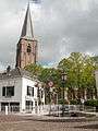 Maasland, churchtower (de Oude Kerk)
 Maasland, windmill: de Dijkmolen
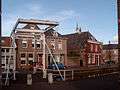 Maasland, drawbridge
 Maasland, the central canal
References
- ↑ Ad van der Meer and Onno Boonstra, Repertorium van Nederlandse gemeenten, KNAW, 2006.
- ↑ Zomer van 2004, Nat en Vrij warm, KNMI News
External links
- Official website
- J. Kuyper, Gemeente Atlas van Nederland, 1865-1870, "Maasland". Map of the former municipality, around 1868.
- Maasland and Midden-Delfland Mooi Dichtbij portal
Coordinates: 51°56′N 4°16′E / 51.933°N 4.267°E