Ma'loula
| Ma'loula ܡܥܠܘܠܐ معلولا | |
|---|---|
| Town | |
|
Overview of Ma'loula | |
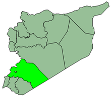
 Ma'loula Location in Syria | |
| Coordinates: 33°50′39″N 36°32′48″E / 33.84417°N 36.54667°E | |
| Country |
|
| Governorate | Rif Dimashq Governorate |
| District | Al-Qutayfah District |
| Nahiyah | Ma'loula |
| Elevation | 1,500 m (4,900 ft) |
| Population (2004 census)[1] | |
| • Total | 2,762 |

Ma'loula, Maaloula, or Ma'lula (Aramaic: ܡܥܠܘܠܐ, Maʿlūlā; Arabic: معلولا Maʿlūlā) is a town in the Rif Dimashq Governorate in Syria. The town is located 56 km to the northeast of Damascus and built into the rugged mountainside, at an altitude of more than 1500 m. It is known as one of three remaining villages where Western Aramaic is still spoken, the other two being the nearby villages Jubb'adin and Al-Sarkha (Bakhah).
Etymology
Maʿlūlā is from the Aramaic word maʿʿəlā (ܡܥܠܐ), meaning 'entrance'. Until recently, the town was dominated by speakers of Western Neo-Aramaic.
Climate
| Climate data for Ma'loula | |||||||||||||
|---|---|---|---|---|---|---|---|---|---|---|---|---|---|
| Month | Jan | Feb | Mar | Apr | May | Jun | Jul | Aug | Sep | Oct | Nov | Dec | Year |
| Average high °C (°F) | 4 (39) |
5 (41) |
7 (45) |
11 (52) |
15 (59) |
19 (66) |
22 (72) |
24 (75) |
18 (64) |
14 (57) |
10 (50) |
5 (41) |
12.8 (55.1) |
| Average low °C (°F) | −3 (27) |
−2 (28) |
0 (32) |
4 (39) |
8 (46) |
12 (54) |
14 (57) |
16 (61) |
12 (54) |
8 (46) |
4 (39) |
−1 (30) |
6 (42.8) |
| Average snowy days | 9 | 6 | 3 | 1 | 0 | 0 | 0 | 0 | 0 | 0 | 2 | 7 | 28 |
| Source #1: World Meteorological Organization,[2] Hong Kong Observatory (sun 1961–1990)[3] | |||||||||||||
| Source #2: BBC Weather (record highs and lows)[4] | |||||||||||||
Population
According to the Syria Central Bureau of Statistics, Ma'loula had a population of 2,762 in the 2004 census.[1] However, during summer, it increases to about 10,000, due to people coming from Damascus for holidays.[5] Half a century ago, 15,000 people lived in Ma'loula.[6]
Religiously, the population consists of both Christians (mainly members of the Greek Orthodox Church of Antioch and the Melkite Greek Catholic Church) and Muslims. For the Muslim inhabitants, the legacy is all the more remarkable given that they were not Arabised, unlike most other Syrians who like them were Islamised over the centuries but also adopted Arabic and shifted to an Arab ethnic identity.[7]
Language
With two other nearby towns al-Sarkha (Bakhah) (Arabic: (الصرخه (بخعة) and Jubb'adin (Arabic: جبّعدين), Ma'loula is the only place where one of the Western Aramaic languages is still spoken, which it has been able to retain amidst the rise of Arabic due to its distance from other major cities and its isolating geological features. However, modern roads and transportation, as well as accessibility to Arabic-language television and print media - and for some time until recently, also state policy - have eroded that linguistic heritage.
As the last remaining places where Western Neo-Aramaic is still spoken, the three villages represent an important source for anthropological linguistic studies regarding first century Western Aramaic. According to scholarly consensus, the language of Jesus was also a Western Aramaic dialect; more specifically the Galilean variety of Jewish Palestinian Aramaic. Despite frequent misstatements in the media,[8] however, the Neo-Aramaic spoken in Ma'loula, Bakhah and Jubb'adin is not identical to the dialect which Jesus of Nazareth spoke, since it underwent significant changes since the first century AD.
Monasteries
There are two important monasteries in Ma'loula: the Eastern Catholic Mar Sarkis and Greek Orthodox Mar Thecla.
Mar Sarkis
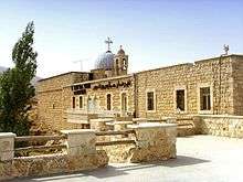
One of the oldest surviving monasteries in Syria. It was built on the site of a pagan temple, and has elements which go back to the fifth to sixth century Byzantine period.[9] Mar Sarkis is the Arabic name for Saint Sergius, a Roman soldier who was executed for his Christian beliefs. This monastery still maintains its solemn historical character.
Mar Sarkis has two of the oldest icons in the world, one depicting the Last Supper.
Mar Taqla

This monastery holds the remains of Thecla, which the second-century Acts of Paul and Thecla accounts a noble virgin and pupil of St. Paul. According to later legend not in the Acts, Taqla was being pursued by soldiers of her father to capture her because of her Christian faith. She came upon a mountain, and after praying, the mountain split open and let her escape through. The town gets its name from this gap or entrance in the mountain. However, there are many variations to this story among the residents of Ma'loula.
Other monasteries
There are also the remains of numerous monasteries, convents, churches, shrines and sanctuaries. There are some that lie in ruins, while others continue to stand, defying age. Many pilgrims come to Ma'loula, both Muslim and Christian, and they go there to gain blessings and make offerings.

War in Syria
Ma'loula became the scene of battle between Al-Qaeda linked jihadist Al-Nusra Front and the Syrian Army in September 2013.[10]
Syrian rebels took over the town on October 21. Around 13 people were killed, with many more wounded.[11]
On October 28, government forces recaptured the town.[11]
Ma'loula was taken over by al-Nusra Front opposing the Syrian government again on December 3, 2013. The Front, took 12 nuns as hostages,[12] the nuns were moved between different locations and ended up in Yabroud and stayed for three months, officials from Qatar and Lebanon negotiated a deal for their release, the negotiations produced an agreement on a prisoner exchange under which around 150 Syrian women detained by the government were also freed,[13] the nuns were freed on the 9th of March 2014, they stated that they were treated well by their captors.[14][15]
On 14 April 2014, with the help of Hezbollah, the Syrian Army once more took control of Ma'loula. This government success was part of a string of other successes in the strategic Qalamoun region, including the seizure of the former rebel bastion of Yabroud in the previous month.[16][17]
Sister city
See also
References
- 1 2 General Census of Population and Housing 2004. Syria Central Bureau of Statistics (CBS). Rif Dimashq Governorate. (Arabic)
- ↑ "World Weather Information Service – Aleppo". World Meteorological Organization. Retrieved 10 November 2012.
- ↑ "Climatological Information for Aleppo, Syria". Hong Kong Observatory. Retrieved 10 November 2012.
- ↑ "Average Conditions Ma'loula, Syria". BBC Weather. Retrieved 10 November 2012.
- ↑
- ↑ Sly, Liz (2003-03-12). "Language of Jesus clings to life". Chicago Tribune.
- ↑ Provence, Michael (2005). The Great Syrian Revolt and the Rise of Arab Nationalism. University of Texas Press. p. 123. ISBN 0-292-70680-4.
- ↑ Black, Ian (2009-04-14). "Endangered Aramaic language makes a comeback in Syria". The Guardian. London.
- ↑ Ross Burns, The Monuments of Syria, I. B. Taurus, 3rd edition 2009, p. 193.
- ↑ "Syria rebels withdraw from ancient Christian town of Maaloula". BBC News. September 6, 2013.
- 1 2 http://barnabasfund.org/UK/Islamists-besiege-two-Christian-villages-in-Syria-13-people-killed.html
- ↑ http://www.ibtimes.co.uk/articles/527153/20131203/syria-abducted-nuns-islamist-rebels-maaloula-christians.htm
- ↑ http://edition.cnn.com/2014/03/09/world/meast/syria-nuns-freed/ ,CNN nuns agreement
- ↑ http://www.reuters.com/article/2014/03/09/us-syria-crisis-nuns-idUSBREA280EL20140309 , Reuters nuns freed
- ↑ http://www.bbc.com/news/world-middle-east-26510202 ,bbc Nuns treated well
- ↑ http://news.yahoo.com/syria-army-retakes-christian-town-maalula-090238420.html
- ↑ "BBC News - Syria rebels driven from Christian town of Maaloula". BBC News. Retrieved 25 October 2014.
External links
| Wikimedia Commons has media related to Maalula. |
- A web site dedicated to Ma'loula
- New York Times article on Aramaic language in Ma'loula and other villages in Syria
- Syrian village clings to Aramaic language at Al Jazeera English
- An episode from Australian program, Foreign Correspondent, about Ma'loula.
- The dialect of Ma'lula. Grammar, vocabulary and texts. (1897–1898) By Jean Parisot (in French): Parts 1, 2, 3 at the Internet Archive.
- Samples of spoken Ma'loula Aramaic at the Semitisches Tonarchiv (Semitic Audio Archive)
Coordinates: 33°50′39″N 36°32′48″E / 33.84417°N 36.54667°E