Maqne
| Maqne مقنة Maakne | |
|---|---|
 Maqne Location in Lebanon | |
| Coordinates: 34°4′40″N 36°12′31″E / 34.07778°N 36.20861°ECoordinates: 34°4′40″N 36°12′31″E / 34.07778°N 36.20861°E | |
| Country |
|
| Governorate | Beqaa Governorate |
| District | Baalbek District |
| Time zone | EET (UTC+2) |
| • Summer (DST) | +3 (UTC) |
| Alternate name | Maakne I, Tell Maakne |
|---|---|
| Location | Beqaa Valley, Lebanon |
| Type | Surface site & Tell |
| Part of | Type site |
| History | |
| Periods | Shepherd Neolithic, Early Bronze Age, Ancient Rome |
| Site notes | |
| Excavation dates | 1957 |
| Archaeologists | M. Billaux, Maurice Tallon, Henri Fleisch |
| Condition | ruins, |
| Public access | Yes |
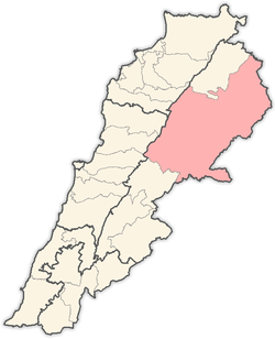
Maqne or Maakne (Arabic: مقنة) is a town and municipality in the Baalbek District of the Beqaa Governorate, Lebanon.[1]
Maqne I
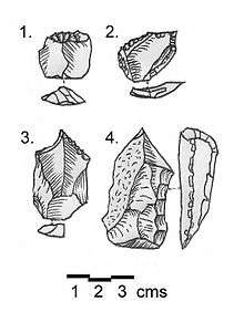
Along with Qaa, Maqne I or Maakne I is a type site of the Shepherd Neolithic industry. The surface site was discovered in 1957 by M. Billaux and the materials found were studied by Henri Fleisch and Maurice Tallon. Findings were published by Fleisch in 1966.[2] The site is located 1 kilometre (0.62 mi) south of the town, east of the road that leads from Baalbek to Homs. The Shepherd Neolithic assemblage found resembled that collected from Qaa and was spread over a sterile area of consolidated Neogene alluvial conglomerates. Lorraine Copeland commented that the industry could be found in no particular concentration around a wide area of the northern Beqaa valley. M. Billaux observed that the worked Shepherd Neolithic flints were of far superior quality than the brittle, unworkable flint conglomerates in the area. He suggested that these flints were imported onto the Beqaa plains from somewhere else.[1]
The Shepherd Neolithic industry can be defined firstly by being small and thick in size, with flakes commonly ranging from 2.5 centimetres (0.98 in) to 4 centimetres (1.6 in), the thickness distinguishing them from geometric microliths. Their second characteristic is the limited number of forms that the tools take, apart from cores being transverse racloirs on small flakes, strong-pointed borers, denticulated or notched thick, short blades and end-scrapers. It was thirdly characterized by a lack of known typology, with only occasional use of Levallois technique. It was determined to be definitely later than the Mesolithic but without any usual forms from the Upper Paleolithic or pottery Neolithic. Henri Fleisch tentatively suggested the industry to be Epipaleolithic and suggested it may have been used by nomadic shepherds.[1] The Shepherd Neolithic has largely been ignored and understudied following the outbreak of the Lebanese civil war.
Tell Maqne
Tell Maqne or Tell Maakne is located in a cemetery 200 metres (660 ft) east of the road between El Ain and Baalbek. It is a mound of grey soil on top of a cliff that overlooks a ravine of the north Nahle that can be accessed by a road to the east of the village. The tell was found by Lorraine Copeland in the August 1966, who collected a variety of cores, scrapers, blades and burins, all with a white patina. Various groups of pottery were found dispersed and broken up around the area. A collection of Early Bronze Age sherds was made that included chevrons and combed impressions resembling similar pieces found at Bchemoun. Another type of pottery found was a thin, yellow and brown washed type considered similar to the "Smeared Wash" type found by Robert John Braidwood at Amuq. Fragments of inverted-rim platters were also discovered with a reddish black burnish. Other sherds were found with a vibrant red or orange burnish that had small, round handles. Another group of pottery found was of a very rough type, made with chaff-holes and large, coarse grits. Other pottery found indicated Roman and later occupations.
Maurice Tallon did not consider that the tumuli to be found on the nearby plains was prehistoric.[3]
References
- 1 2 3 L. Copeland; P. Wescombe (1966). Inventory of Stone-Age Sites in Lebanon: North, South and East-Central Lebanon, p. 44 & 74. Impr. Catholique. Retrieved 29 August 2011.
- ↑ Fleisch, Henri., Notes de Préhistoire Libanaise : 1) Ard es Saoude. 2) La Bekaa Nord. 3) Un polissoir en plein air. BSPF, vol. 63, 1966.
- ↑ Tallon, M., Tumulus et Mégalithes du Hermel et de la Beqa Nord. Mélanges de l'Université Saint Joseph, Volume 31, fasc. 3, p. 91, 1959.
External links
- Maqneh, Localiban
Capital: Baalbek | ||
| Towns and villages |
|  |
| Other | ||