Ma'alul
| Ma'alul | |
|---|---|
|
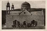
A restored church in Ma'lul in July 2010 | |
 Ma'alul | |
| Arabic | معلول |
| Name meaning | from personal name[1] |
| Also spelled | Ma'lul, Maalul, Maaloul, Mahlul |
| Subdistrict | Nazareth |
| Coordinates | 32°41′44.12″N 35°14′22.18″E / 32.6955889°N 35.2394944°ECoordinates: 32°41′44.12″N 35°14′22.18″E / 32.6955889°N 35.2394944°E |
| Palestine grid | 172/233 |
| Population | 690 (1945) |
| Area |
4,698 dunams 4.7 km² |
| Date of depopulation | 15 July 1948[2] |
| Cause(s) of depopulation | Military assault by Yishuv forces |
| Current localities | Migdal HaEmek, Kfar HaHoresh, Timrat,[3][4] and an Israeli military base |

Ma'alul (Arabic: معلول) was a village, made up primarily of Palestinian Christians, that was depopulated and destroyed by Israel during the 1948 Arab-Israeli war. Located six kilometers west of the city of Nazareth,[5] many of its inhabitants became internally displaced refugees, after taking refuge in Nazareth[6] and the neighbouring town of Yafa an-Naseriyye.[7] Despite having never left the territory that came to form part of Israel, the majority of the villagers of Maalul, and other Palestinian villages like Andor and Al-Mujidal, were declared "absentees", allowing for the confiscation of their land under the Absentees Property Law.[8]
Today, much of the former village's lands are owned by the Jewish National Fund.[9] All that remains of its former structures are two churches, a mosque and a Roman era mausoleum, known locally as Qasr al-Dayr ("Castle of the monastery").[5]
History
In 1850, Rabbi Joseph Schwartz identified Ma'alul with the Biblical town of Nahalal.[10][11]
Ottoman era
Incorporated into the Ottoman Empire in 1517, Ma'alul appeared in the census of 1596, located in the nahiya ("subdistrict") of Tiberias under the liwa' ("district") of Safad with a population of seventy-seven. It paid taxes on a number of crops, including wheat and barley, as well as goats and beehives.[12][13] Pierre Jacotin called the village Matoun on his map from 1799.[14]
Ma'alul, and the neighbouring towns and villages of Nazareth, Mejdal, Yafa, Jebatha and Kneffis paid taxes to the monks of Nazareth, who bought the right to collect these taxes from the Ottoman authorities in 1777 for two hundred dollars. Thirty years later, they again purchased this right, though this time for two thousands five hundred dollars, owing to the rise in the price of cereals and ground rents.[15]
By the late nineteenth century, the village was made of adobe bricks, built on a hill, with an estimated population of 280, who cultivated 42 faddans of land. Just outside the village was a magnificent Roman mausoleum, called Qasr al-Dayr.[16]
British Mandate era
According to the British Mandate's 1922 census of Palestine, Ma'alul had 436 inhabitants; 186 Muslims and 250 Christians,[17] where all the Christians were Orthodox.[18]
At the beginning of the twentieth century, the people of Ma'alul were tenants of the Sursuq family of Beirut, absentee landlords who had acquired the village lands earlier. In 1911 the Sursuqs sold all but 2,000 dunams of Ma'alul's land to the Zionist Palestine Land Development Company.[19] The remaining 2,000 dunums were insufficient to support the village's population, so at the request of the Mandate government, the company agreed to lease an additional 3,000 dunams to the villagers until 1927. The villagers had the option to buy this land before the lease expired.[4]
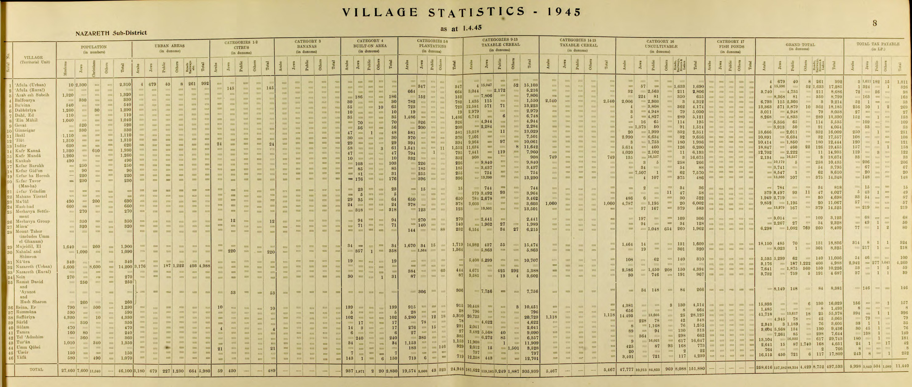
By the 1931 census the population had decreased to 390; 228 Muslims, and 162 Christians, in a total of 90 houses.[20] In 1945 the population of Ma'alul was 690; 490 Muslims and 200 Christians,[21] with a total of 4,698 dunams of land, according to an official land and population survey.[22] Of this, a total of 650 dunams were for plantations and irrigable land, 3,462 for cereals,[23] while 29 dunams were built-up land.[24]
1948, and aftermath
The village was captured by the Israeli army on 15 July 1948 during Operation Dekel. The villagers were forced to leave and the houses destroyed.[4]
In 1949 an Israeli military base was built on village land.[25]
Walid Khalidi describes the remains of Ma'alul in 1992:
The village site is now covered with a pine forest planted by the Jewish National Fund and dedicated to the memory of prominent Jews and some non-Jewish Americans and Europeans. A military base is also on the site. The mosque and two churches still stand, and are used intermittently as cow sheds by the residents of Kibbutz Kefar ha-Choresh. Overlooking Wadi al-Halabi, between the village site and the site of al-Mujaydil, is an Israeli plastics factory. Cactus, olive trees, and fig trees grow on the site, which is strewn with piles of stones. A few tombs in the Muslim cemetery across from the mosque can be seen. The main village site also contains the remains of houses.[26]
Documentary: Ma'loul Celebrates its Destruction
Ma'alul was the object of the 1985 documentary film by Michel Khleifi; Ma'loul Celebrates its Destruction.[27][28]
See also
References
- ↑ Palmer, 1881, p. 113
- ↑ Morris, 2004, p. xvii, village #138. Also gives cause of depopulation.
- ↑ Morris, 2004, p. xx, settlement #12.
- 1 2 3 Khalidi, 1992, p. 347
- 1 2 Ma'lul, Palestine Remembered, retrieved 2008-03-31
- ↑ Rabinowitz, 1997, p. 27
- ↑ Nihad Bokae'e (February 2003), Palestinian Internally Displaced Persons inside Israel:Challenging the Solid Structures (PDF), Badil, archived from the original (PDF) on June 14, 2007
- ↑ Hal Draper (Winter 1957), "Israel's Arab Minority:The Great Land Robbery", New International, XXIII (1): 7–30, retrieved 2008-03-31
- ↑ Merrilee Langenbrunner (December 1, 2002), Mourning the departure of Arab Christians, Catholic New Times, retrieved 2008-03-31
- ↑ Keil, 1865, p. 194
- ↑ Schwarz, 1850, p. 172
- ↑ Hütteroth and Abdulfattah, 1977, p. 189. Quoted in Khalidi, p. 346.
- ↑ Note that Rhode, 1979, p. 6 writes that the register that Hütteroth and Abdulfattah studied was not from 1595/6, but from 1548/9
- ↑ Karmon, 1960, p. 167
- ↑ De Haas, 1934, p. 361
- ↑ Conder and Kitchener, 1881, SWP I, pp. 274 - 322-335 Quoted in Khalidi, 1992, p. 347
- ↑ Barron, 1923, Table XI, Sub-district of Nazareth, p. 38
- ↑ Barron, 1923, Table XVI, p. 50
- ↑ a total of 16,000 dunams, with 90 families, according to List of villages sold by Sursocks and their partners to the Zionists since British occupation of Palestine, evidence to the Shaw Commission, 1930
- ↑ Mills, 1932, p. 74
- ↑ Department of Statistics, 1945, p. 8
- ↑ Government of Palestine, Department of Statistics. Village Statistics, April, 1945. Quoted in Hadawi, 1970, p. 62
- ↑ Government of Palestine, Department of Statistics. Village Statistics, April, 1945. Quoted in Hadawi, 1970, p. 109
- ↑ Government of Palestine, Department of Statistics. Village Statistics, April, 1945. Quoted in Hadawi, 1970, p. 159
- ↑ Pappe, 2006, p. 216
- ↑ Khalidi, 1992, p. 348
- ↑ Dabashi, Hamid, and Said, Edward (preface) (2006): Dreams Of A Nation: On Palestinian Cinema, Verso Books, London, United Kingdom, ISBN 1-84467-088-0, Chapter 4: Bashir Abu-Manneh: Towards Liberation: Michel Khleifi's Ma'loul and Canticle (p. 58-69)
- ↑ Gertz, Nurith; Khleifi, George (2008): Palestinian Cinema: Landscape, Trauma, and Memory, Indiana University Press. ISBN 0-253-22007-6 p.80-81
Bibliography
| Wikimedia Commons has media related to Ma'alul. |
- Barron, J. B., ed. (1923). Palestine: Report and General Abstracts of the Census of 1922. Government of Palestine.
- Conder, Claude Reignier; Kitchener, Herbert H. (1881). The Survey of Western Palestine: Memoirs of the Topography, Orography, Hydrography, and Archaeology. 1. London: Committee of the Palestine Exploration Fund.
- Department of Statistics (1945). Village Statistics, April, 1945. Government of Palestine.
- De Haas, Jacob (1934). History of Palestine - The Last Two Thousand Years. Macmillan.
- Hadawi, Sami (1970). Village Statistics of 1945: A Classification of Land and Area ownership in Palestine. Palestine Liberation Organization Research Center.
- Hütteroth, Wolf-Dieter; Abdulfattah, Kamal (1977). Historical Geography of Palestine, Transjordan and Southern Syria in the Late 16th Century. Erlanger Geographische Arbeiten, Sonderband 5. Erlangen, Germany: Vorstand der Fränkischen Geographischen Gesellschaft. ISBN 3-920405-41-2.
- Karmon, Y. (1960). "An Analysis of Jacotin's Map of Palestine" (PDF). Israel Exploration Journal. 10 (3,4): 155–173; 244–253.
- Keil, Carl Friedrich (1865). Joshua, Judges, Ruth, tr. by J. Martin. Oxford University.
- Khalidi, Walid (1992). All That Remains: The Palestinian Villages Occupied and Depopulated by Israel in 1948. Washington D.C.: Institute for Palestine Studies. ISBN 0-88728-224-5.
- Mills, E., ed. (1932). Census of Palestine 1931. Population of Villages, Towns and Administrative Areas. Jerusalem: Government of Palestine.
- Morris, Benny (2004). The Birth of the Palestinian Refugee Problem Revisited. Cambridge University Press. ISBN 978-0-521-00967-6.
- Palmer, E. H. (1881). The Survey of Western Palestine: Arabic and English Name Lists Collected During the Survey by Lieutenants Conder and Kitchener, R. E. Transliterated and Explained by E.H. Palmer. Committee of the Palestine Exploration Fund.
- Pappé, Ilan (2006). The Ethnic Cleansing of Palestine. London and New York: Oneworld. ISBN 1-85168-467-0.
- Rabinowitz, Dan (1997). Overlooking Nazareth: The Ethnography of Exclusion in Galilee. Cambridge University Press. ISBN 0-521-56495-6.
- Rhode, Harold (1979). Administration and Population of the Sancak of Safed in the Sixteenth Century. Columbia University.
- Schwarz, Joseph (1850). A Descriptive Geography and Brief Historical Sketch of Palestine. Translated by Isaac Leeser. Macmillan.
External links
- Welcome To Ma'lul
- Survey of Western Palestine, Map 5: IAA, Wikimedia commons
- Ma'lul, at Khalil Sakakini Cultural Center
- Ma3lul photos from Dr. Moslih Kanaaneh
- The Palestinian narrative has won, By Oudeh Basharat, Haaretz, 24.03.2011