Ma'alot-Tarshiha
Ma'alot-Tarshiha
| ||
|---|---|---|
| Hebrew transcription(s) | ||
| • ISO 259 | Maˁlot Taršiḥaˀ | |
| • Translit. | Maʻalot-Tarshiḥa | |
 | ||
| ||
 Ma'alot-Tarshiha | ||
| Coordinates: 33°1′0″N 35°16′15″E / 33.01667°N 35.27083°ECoordinates: 33°1′0″N 35°16′15″E / 33.01667°N 35.27083°E | ||
| Grid position | 175/268 PAL | |
| District | Northern | |
| Founded | 12th century | |
| Government | ||
| • Type | City (from 1996) | |
| • Mayor | Shlomo Bohbot | |
| Area | ||
| • Total | 6,832 dunams (6.832 km2 or 2.638 sq mi) | |
| Population (2015)[1] | ||
| • Total | 21,227 | |
| Name meaning | Teir Shiha: Teir, a fortress. Shih is a fragrant herb.[2] | |
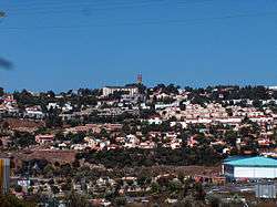
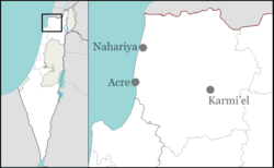
Ma'alot-Tarshiha (Hebrew: מַעֲלוֹת-תַּרְשִׁיחָא; Arabic: معالوت ترشيحا, Maʻālūt Taršīḥā) is a mixed city in the North District in Israel, some 20 kilometres (12 miles) east of Nahariya, about 600 metres (1,969 feet) above sea level. The city was established in 1963 through a municipal merger of the Arab town of Tarshiha and the Jewish town of Ma'alot. In 2015 the city has a population of 21,227.
History
Tarshiha
Excavations of a 4th-century burial cave in the village unearthed a cross and a piece of glass engraved with a menorah.[3]
Crusader sources from the 12th and 13th century refer to Tarshiha as Terschia, Torsia and Tersigha.[4] The King had initiated the settlement of Crusader (Latin, Frankish) people in nearby Mi'ilya ("Castellum Regis"), and from there settlement spread out to Tarshiha.[5] In 1160, Torsia and several surrounding villages were transferred to a Crusader named Iohanni de Caypha (Johannes of Haifa).[6] By 1217, the village was probably inhabited by Crusader ("Frankish") people.[7] In 1220 Joscelin III´s daughter Beatrix de Courtenay and her husband Otto von Botenlauben, Count of Henneberg, sold their land, including Tersyha, to the Teutonic Knights.[8] In 1266, Tarshiha was raided by Crusader troops.[4]
According to popular Arabic etymology, the name may have meant "Artemisia Mountain" in the Canaanite language, where Arabic Tuur for "mountain" and shiiH for Artemisia vulgaris (mugwort, or common wormwood) could be identified, or from Taar shiiHaa ("Shiha flew"), i.e. Shiha Jamaluddin (a legendary hero) rushed to the battlefield to fight the Crusaders.
Ottoman era
Incorporated into the Ottoman Empire in 1517 with the rest of Palestine, the village of Tarshiha was raided by the Lebanese feudal chief, Mansur ibn Furaykh in 1573.[4] The daftar of 1596 show the village to be under the administration of the nahiya of Akka, with a population of 107 households ("khana") and 3 bachelors, all Muslim. The inhabitants paid taxes on "occasional revenues", bees and goats. The village was also taxed for a press, used either of olives or for grapes.[9][10]
In the early eighteenth century, the village was under control of Shaikh Husayn,[11] while later in the Ottoman period it became one of the major cotton-producing villages of Galilee, and the administrative center of the nahiya.[12] Mariti visited the village (which he called Terschia) in 1761, and wrote that it "abounds with water; which adds greatly to the fertility of its cotton plants, its fruit-trees, and above all its tobacco".[13]
V. Guérin, who visited in 1875, found that Tarshiha "consists of four quarters, under the jurisdiction of as many different sheikhs. There are 2,000 Moslems, who have their mosques. The Christians occupy their own quarters: with the exception of a few families they are all United Greeks, and number about 500."[14] In 1881 the Palestine Exploration Fund's Survey of Western Palestine described Tarshiha as: "a very large village, containing about 1,500 Moslems and 300 Christians; there is a fine mosque with minarets newly built, also an old one; the houses are well-built; a new and handsome church has been built in the Christian quarter".[15]
British Mandate era
In the 1922 census of Palestine conducted by the British Mandate authorities, Tarsheha had a population of 1,880 residents; 1,521 Muslims, 358 Christians and 1 Druze,[16] increasing in the 1931 census to a total of 2522; 2047 Muslims and 475 Christians, in a total of 584 houses.[17]
In 1945 the population of Tarshiha was 3,840; 3140 Muslims and 690 Christians.[18][19][20] The total population of Tarshiha combined with Al-Kabri was 5,360 Arabs, with 47,428 dunams of land.[21] Of this, a total of 743 dunums of land in the two places was used for citrus and bananas, 5,301 were plantation and irrigable land, 14,123 for cereals,[22] while 252 dunams were built-up (urban) land.[23]
1947 war
During the 1948 Arab-Israeli War Tarshiha served as the headquarters of Fawzi al-Qawuqji, who headed the Arab Liberation Army. Tarshiha was in the territory allotted to the Arab state under the 1947 UN Partition Plan.[24]
Israeli rule
In the 1948 Arab-Israeli War, the village was captured by the Israel Defense Forces in Operation Hiram. The village was bombed by three Israeli planes on the evening of 28 October. This was followed by a prolonged artillery barrage and a further air raid in the morning with the village defenders and most of the inhabitants retreating north into Lebanon.[25][26] The village was captured by the Israel Defense Forces on October 29.[27] A UN observer reported that on 1 November 1948 the Palestinian villages around Tarshiha were deserted and extensively looted by Israeli forces. The New York Times added that the looting appeared systematic, as Israeli army trucks were used carrying off the looted goods.[28] By December 1948 around 700 villagers, mostly Christians, had returned to the village.[29]
Any Arab who had not registered, as of November 1948, was regarded as illegal and if caught deported. An American Quaker relief worker with the American Friends Service Committee described a raid on Tarshiha on 15 January 1949. All males over sixteen were questioned by a panel of eight Israelis. 33 heads of families and 101 family members, aged 1 year to 79 years, were selected for deportation. They were robbed and expelled via 'Ara to Jenin. A UN observer in Jenin reported that their homes were being re-populated by large numbers of Jewish refugees from Austria.[30] In December 1949 the Israeli Foreign Ministry blocked an IDF plan to clear Tarshiha and five other villages along the Lebanon border of their remaining Arab populations in order to create an 5 to 10 kilometres (3 to 6 miles) Arab-free zone.[31] Arabs in the Galilee remained under Martial Law until 1966.
Ma'alot
Ma'alot was established as a development town for Jewish immigrants from Romania, Iran, Lebanon and Morocco, in 1957. The first homes were built on Har HaRakafot (Cyclamen Hill), known in Arabic as Bab Al-Hauwa ("Gate of the Winds").
Joint Ma'alot-Tarshiha
In 1963, Ma'alot was merged with the larger Tarshiha, and the unified town was renamed to reflect both origins. The inhabitants of Tarshiha hoped that the merger would improve the level of services.
On 15 May 1974, an elementary school in Ma'alot was attacked by terrorists of the Democratic Front for the Liberation of Palestine in what became known as the Ma'alot massacre.[32] Twenty-two teenagers and three teachers from Safed on a class trip were murdered in the attack. They had been sleeping on the floor inside the building.[33] In addition, three Israeli women, one of them seven months pregnant, one four-year-old child, and two men were killed by the same terrorists in the events before the murder of the school children.[34]
Ma'alot-Tarshiha was officially recognized as a city in 1996.
Nearly 700 Katyusha rockets landed in the vicinity of Ma'alot-Tarshiha during the Second Lebanon War. Three Arab residents of the city were killed in a rocket attack.[35]
Demographics and income
In 2001, ethnic and religious makeup of the city was 79.7% Jewish and other non-Arabs, and 20.0% Arab (8.9% Muslim, 9.9% Christian, and 1.0% Druze). In the early 2000s, 52% of the population were Russian immigrants. In 2001, there were 10,100 males and 10,100 females. The population of the city was diverse in age with 35.7% 19 years of age or younger, 15.3% between 20 and 29, 20.4% between 30 and 44, 14.6% from 45 to 59, 3.9% from 60 to 64, and 10.0% 65 years of age or older. The population growth rate in 2001 was 3.0%.
As of 2000, CBS reported there were 6,931 salaried workers and 408 self-employed persons in the city. The mean monthly wage in 2000 for a salaried worker was NIS 4,435, a real change of 7.0% over the course of 2000. Salaried men had a mean monthly wage of NIS 5,652 (a real change of 9.9%) versus NIS 3,073 for women (a real change of 2.0%). The average income for the self-employed was NIS 6,320. There were 559 people who received unemployment benefits, and 1,785 people who received an income guarantee.
Economy
The Iscar plant and industrial parks built in the vicinity of Ma'alot-Tarshiha by Stef Wertheimer are major sources of employment for the city's residents. In 2007, the jobless rate in Ma’alot-Tarshiha was 5.5 percent, compared to 7.9 percent nationally.[36]
Education
In 2001, there were 11 schools and 4,272 students in the city, including 7 elementary schools with an enrollment of 2,000, and 7 high schools with 2,272 students. 58.5% of the city's 12th graders earned a matriculation certificate in 2001. In August 1975, Yeshivat Ma'alot, a Hesder yeshiva, was established, attracting students from all over the world. In recent years the Yeshiva has estimated 300 students per year.
Landmarks and culture
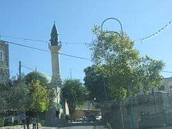
Guérin, after his 1875 visit, wrote that the principal mosque in Tarshiha had been built by Abdullah Pasha, (the Governor of Acre at the time.) He further noted that it was "preceded by a court, then by a porch; surmounted by a cupola, above which springs an elegant minaret."[37] Andrew Petersen, who inspected the mosque in 1993, noted that it was built in "classical Ottoman style with four main elements: a courtyard, an arcade, a domed prayer hall, and a minaret."[38]
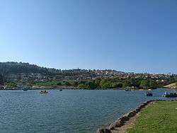
Lake Monfort, an artificial lake to the east of Ma'alot-Tarshiha, has become a local tourist attraction. It was previously known as the Hosen Reservoir. The lake is featured in the city's emblem.
In January 2008, Ma'alot-Tarshiha hosted the Israel International Chess Championship. The tournament, held at the community center, carried a prize of $20,000. The city has also hosted other international events, among them an international fencing tournament.[39] The "Stone in the Galilee" International Sculpture Symposium has been held annually in Ma'alot-Tarshiha since 1991. In this 10-day springtime event, sculptors from Israel and around the world convene at Montfort Lake to create stone sculptures from huge blocks of stone.[40]
In 2009, the non-profit Docaviv established an annual documentary film festival in the city in an effort to bring "high quality cultural activity to the Israeli periphery."[41]
Twin Towns — Sister Cities
References
- ↑ "List of localities, in Alphabetical order" (PDF). Israel Central Bureau of Statistics. Retrieved 16 October 2016.
- ↑ Palmer, 1881, p. 55
- ↑ Hachlili, Rachel (2001). The Menorah, the Ancient Seven-armed Candelabrum: Origin, Form, and Significance. Brill. pp. 108–109. ISBN 9789004120174.
- 1 2 3 Petersen, 2001, p. 293
- ↑ Ellenblum, 2003, pp. 44, fig 1. 68, 95, 213
- ↑ Strehlke, 1869, pp. 2-3, No. 2; Cited in Röhricht, 1893, RRH, p. 89, No. 341; cited in Frankel, 1988, pp. 263, 267
- ↑ Strehlke, 1869, p. 41, no. 49; Cited in Ellenblum, 2003, p. 53
- ↑ Strehlke, 1869, pp. 43- 44, No. 53; cited in Röhricht, 1893, RHH, p. 248, No. 934 (2); cited in Frankel, 1988, p. 263
- ↑ Hütteroth and Abdulfattah, 1977, p. 192. Quoted in Petersen, 2001, pp. 293-4
- ↑ Note that Rhode, 1979, p. 6 writes that the register that Hütteroth and Abdulfattah studied was not from 1595/6, but from 1548/9
- ↑ Cohen, 1973, p. 9. Quoted in Petersen, 2001, p. 294
- ↑ Cohen, 1973, pp. 12, 121. Quoted in Petersen, 2001, p. 294
- ↑ Mariti, 1792, p. 339
- ↑ Guérin, 1880, pp. 63-64, as translated by Conder and Kitchener, 1881, SWP I, p. 149
- ↑ Conder and Kitchener, 1881, SWP I, p. 149
- ↑ Barron, 1923, Table XI, Sub-district of Acre, p. 36
- ↑ Mills, 1932, p. 103
- ↑ Village Statistics The Palestine Government, April 1945, p. 3
- ↑ Khalidi, 1992, p. 19
- ↑ Morris, 1987, p. 239. Gives the population as 4-5,000. 4/5 Muslim.
- ↑ Government of Palestine, Department of Statistics. Village Statistics, April, 1945. Quoted in Hadawi, 1970, p. 41
- ↑ Government of Palestine, Department of Statistics. Village Statistics, April, 1945. Quoted in Hadawi, 1970, p. 81
- ↑ Government of Palestine, Department of Statistics. Village Statistics, April, 1945. Quoted in Hadawi, 1970, p. 131
- ↑ Palestine Plan of Partition (Map). United Nations. Retrieved 2008-10-25.
- ↑ Khalidi, 1992, pp.13,477
- ↑ O'Ballance, Edgar (1956) The Arab-Israeli War. 1948. Faber & Faber, London. pp. 188, 190. Writes of an Arab Liberation Army garrison in the village.
- ↑ "Tour and Signposting in Tarshiha". Zochrot. 2006-11-11. Retrieved 2008-10-25.
- ↑ Khalidi, 1992, p.6
- ↑ Morris, 1987, pp. 194, 225, 239. 100 Muslims and 600 Christians.
- ↑ Morris, 1993, p. 145
- ↑ Morris, 1987, p. 242
- ↑ "Top 10 Worst School Massacres". The List Universe. Retrieved 2008-10-25.
- ↑ "1974: Dozens Die as Israel Retaliates for Ma'alot". BBC. 1974-05-16. Retrieved 2008-10-25.
- ↑ "Bullets, Bombs and a Sign of Hope", TIME, May 27, 1974.
- ↑ Ben Simon, Daniel. "On TV, They Said There Were No Katyushas Left". Haaretz. Retrieved 2008-10-25.
- ↑ Sher, Hanan (November 2007). "$4 Billion Man". 89. Hadassah Magazine. Retrieved 2008-10-25.
- ↑ Guérin, 1880, pp. 63-64, as translated by Conder and Kitchener, 1881, SWP I, p. 149, and cited in Petersen, 2002, p.294
- ↑ Petersen, 2001, p. 294
- ↑ Khoury, Jack (2008-01-17). "12-Year-Old Kfar Sava Girl Defeats 20 Men (In Chess Tournament)". Haaretz. Retrieved 2008-05-28.
- ↑ "Ma'alot". B&B Israel. Retrieved 2008-10-25.
- ↑ "Docaviv (Hebrew)". Docaviv. Retrieved 2012-10-15.
- ↑ "Cooperation Between Israel and the State of Pennsylvania". American-Israeli Cooperative Enterprise. Retrieved 2009-08-04.
Bibliography
| Wikimedia Commons has media related to Ma'alot-Tarshiha. |
- Barron, J. B., ed. (1923). Palestine: Report and General Abstracts of the Census of 1922. Government of Palestine.
- Cohen, A. (1973), Palestine in the Eighteenth Century: Patterns of Government and Administration, Hebrew University, Jerusalem. Cited in Petersen, (2001)
- Conder, Claude Reignier; Kitchener, H. H. (1881). The Survey of Western Palestine: Memoirs of the Topography, Orography, Hydrography, and Archaeology. 1. London: Committee of the Palestine Exploration Fund.
- Ellenblum, Ronnie (2003). Frankish Rural Settlement in the Latin Kingdom of Jerusalem. Cambridge University Press. ISBN 9780521521871.
- Frankel, Rafael (1988). "Topographical notes on the territory of Acre in the Crusader period". Israel Exploration Journal. 38 (4): 249–272.
- Guérin, Victor (1880). Description Géographique Historique et Archéologique de la Palestine (in French). 3: Galilee, pt. 2. Paris: L'Imprimerie Nationale.
- Hadawi, Sami (1970). Village Statistics of 1945: A Classification of Land and Area ownership in Palestine. Palestine Liberation Organization Research Center.
- Hütteroth, Wolf-Dieter; Abdulfattah, Kamal (1977). Historical Geography of Palestine, Transjordan and Southern Syria in the Late 16th Century. Erlanger Geographische Arbeiten, Sonderband 5. Erlangen, Germany: Vorstand der Fränkischen Geographischen Gesellschaft. ISBN 3-920405-41-2.
- Khalidi, Walid (1992). All That Remains: The Palestinian Villages Occupied and Depopulated by Israel in 1948. Washington D.C.: Institute for Palestine Studies. ISBN 0-88728-224-5.
- Mariti, Giovanni (1792). Travels Through Cyprus, Syria, and Palestine; with a General History of the Levant. 1. Dublin: P. Byrne.
- Mills, E., ed. (1932). Census of Palestine 1931. Population of Villages, Towns and Administrative Areas. Jerusalem: Government of Palestine.
- Morris, Benny (1993). Israel's Border Wars, 1949 - 1956. Arab Infiltration, Israeli Retaliation, and the Countdown to the Suez War. Oxford University Press. ISBN 0-19-827850-0.
- Morris, Benny (1987). The Birth of the Palestinian refugee problem, 1947-1949. Cambridge University Press. ISBN 0-521-33028-9.
- Morris, Benny (2004). The Birth of the Palestinian Refugee Problem Revisited. Cambridge University Press. ISBN 0-521-00967-7.
- Palmer, E. H. (1881). The Survey of Western Palestine: Arabic and English Name Lists Collected During the Survey by Lieutenants Conder and Kitchener, R. E. Transliterated and Explained by E.H. Palmer. Committee of the Palestine Exploration Fund.
- Petersen, Andrew (2001). A Gazetteer of Buildings in Muslim Palestine (British Academy Monographs in Archaeology). I. Oxford University Press. ISBN 978-0-19-727011-0. (Tarshiha:293-296)
- Rhode, Harold (1979). Administration and Population of the Sancak of Safed in the Sixteenth Century. Columbia University.
- Robinson, Edward; Smith, Eli (1841). Biblical Researches in Palestine, Mount Sinai and Arabia Petraea: A Journal of Travels in the year 1838. 3. Boston: Crocker & Brewster. (p. 376)
- Röhricht, Reinhold (1893). (RRH) Regesta regni Hierosolymitani (MXCVII-MCCXCI) (in Latin). Berlin: Libraria Academica Wageriana.
- Shammas, Anton (1988), The Retreat from Galilee, Granta 23, Spring 1988. ISBN 014-00-8603-X
- Strehlke, Ernst, ed. (1869). Tabulae Ordinis Theutonici ex tabularii regii Berolinensis codice potissimum. Berlin: Weidmanns.
External links
- Official city website
- Welcome To Tarshiha
- Survey of Western Palestine, Map 3: IAA, Wikimedia commons