Military Ocean Terminal at Bayonne
| Military Ocean Terminal at Bayonne | |
|---|---|
| Bayonne, New Jersey | |
| Site information | |
| Controlled by |
United States Navy (1942-1967) United States Army (1967-1999) |
| Site history | |
| Built | 1939–1942 |
| In use | 1942–1999 |
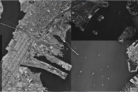
Coordinates: 40°39′49.3″N 74°4′8.7″W / 40.663694°N 74.069083°W Military Ocean Terminal at Bayonne (MOTBY) was a U.S. military ocean terminal located in the Port of New York and New Jersey which operated from 1942 to 1999. The site is on Upper New York Bay south of Port Jersey on the eastern side of Bayonne, New Jersey.[1][2] Since its closure it has undergone maritime, residential, commercial, and recreational mixed-use development. Part of the Hudson River Waterfront Walkway runs along its perimeter.
History
In 1932, a basic plan was initiated to build a port terminal off the east coast of Bayonne into the bay to create additional industrial, maritime, and distribution space. After the plan was completed in 1939, dredging and filling began. At the outbreak of World War II, the United States Navy was looking for a location for a port on the East Coast and became interested in the site for a large dry-dock and supply center. The Bayonne military base was opened by the Navy in 1942 as a logistics and repair base, well connected to the transportation network of the Northeast Corridor. After the war MOTBY became port for part of the Atlantic Reserve Fleet or the Mothball Fleet.
In 1967, the peninsula became a US Army base.[3] It was a large shipping terminal by the standards of the day, and had the largest dry-dock on the eastern seaboard. Once cargo arrived at MOTBY, it could be placed directly into covered warehouses, or onto uncovered, but fully secure staging areas. All types of cargo, from heavy, outsized weapons such as the M1A2 tank and the Patriot missile, to the full range of munitions available to fighting forces could be loaded by Bayonne's specially trained unionized work force using state of the art, dedicated rail lines. Every type of roll-on/roll-off vessel in the Military Sealift Command (MSC) inventory could be accommodated. This capability was used during the Persian Gulf War (2 August 1990 – 28 February 1991) and during operations in Somalia and Haiti. Dozens of military units (men and equipment) were shipped through MOTBY, as was outsized cargo such as M1A2 tanks from as far as Fort Hood, Texas. The facility closed in 1999 under a US Base Realignment and Closure 1995 directive.[4]
Redevelopment plans
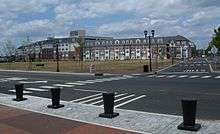
After closure, bids to permanently berth the battleship USS New Jersey, which had been decommissioned at the Atlantic Reserve Fleet from 1948 to 1967, were unsuccessful.[5] The long pier has since been renamed The Peninsula at Bayonne Harbor by the Bayonne Local Redevelopment Authority (BLRA)[6] and is being redeveloped into a mix-used waterfront community of residential, light industrial, commercial, and recreational space. Construction is planned to take place in phases, with one section of housing currently completed.
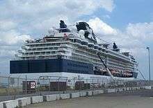
A memorial park for the Tear of Grief, commemorating September 11th, 2001 and the Cape Liberty Cruise Port[7] are located at the end of the long pier. In 2005, eight PCC trolley cars from the Newark City Subway were given to the Bayonne to be rehabilitated and operated along a proposed 2.5-mile (4.0 km) loop to connect to the 34th Street station of the Hudson-Bergen Light Rail.[8]
Much of the HBO prison drama Oz was filmed around MOTBY.[9]
Port Authority purchase
In 2010, the Port Authority of New York and New Jersey purchased 130 acres (0.53 km2) along the waterfront for future use.[10][11] The Port Authority said it would likely not use the land for housing as currently zoned, indicating that additional port facilities would be created.[12] On July 29, the city council approved the sale at a price of $235 million, to be paid out over 24 years, much less than the city had hoped to earn from developing the property for housing. However economic conditions were not favorable to that project, which envisioned 6,700 housing units, and the city needed the cash to balance its budget. The Port Authority planned to develop the property as a container port capable of handling the larger container ships in service after the new, wider Panama Canal opened.[13] Some of these new ships would not fit under the original Bayonne Bridge, preventing them from reaching the large container facilities at Port Newark and Port Elizabeth,[14] however, the roadway on the Bayonne Bridge is being replaced with a higher one, removing the obstacle to shipping. Transhipment of containers to the national rail network from the property would be possible via the National Docks Secondary line using Lehigh Valley Railroad Bridge over Newark Bay,[15][16] to the Long Dock Tunnel through Bergen Hill.
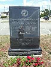
Originally, a condition of the land sale was that the monuments to United States Marines who fought in the Korean War, and the 100-foot (30 m) Tear of Grief would be relocated. However, the move is no longer planned. [17][18]
In 2015, the Bayonne City Council settled lawsuits with the original developers of the property. As part of the settlement, the Port Authority agreed not to develop its land as a container port for 30 years.[19] Residential development of the western and southern portions of the peninsula will go forward, including a pedestrian bridge over Route 440 connecting to the 34th Street HBLR station.[20]
See also
References
- ↑ "History of the Authority". Bayonne Local Redevelopment Authority. Retrieved 2009-05-04.
- ↑ "Cruise Liberty.com - Home". cruiseliberty.com.
- ↑ Strunsky, Steve (February 25, 2001). "CITIES; Bayonne's Terminal Catches Hollywood's Eye". The New York Times.
- ↑ John Pike. "Bayonne Military Ocean Terminal [MOTBY]". globalsecurity.org.
- ↑ http://battleshipnj.netlabs.net/nl-fall98.html
- ↑ "bayonnelra.com". bayonnelra.com.
- ↑
- ↑ Peninsula at Bayonne Harbor development plan, page 17, accessed July 25, 2006
- ↑ Wright, E. Assata. "Getting the film crews back to NJ", The Union City Reporter, February 13, 2011, Pages 5 and 7
- ↑ "Press Release Article". panynj.gov.
- ↑ http://www.seaportsinfo.com/panynj/portfacilities/?page=home
- ↑ "Bayonne board votes to sell land at Harbor to Port Authority". NJ.com.
- ↑ http://www.dredgingtoday.com/2010/06/26/usa-transformation-of-former-military-ocean-terminal-at-bayonne-into-commercial-port/
- ↑ Severson, Kim (December 11, 2010). "A Race to Capture a Bounty From Shipping". The New York Times.
- ↑ NJDOT Web Development Unit. "Liberty Corridor, National Docks Rail Clearance, Phase I Projects, In the Works". state.nj.us.
- ↑ "A SMALL, COSTLY TUNNEL; OPPOSITION AND LITIGATION DOUBLED ITS EXPENSE. Pennsylvania Railroad Company Objected to the National Docks and New-Jersey Hallway Company Passing Under its Tracks in Jersey City to Connect with the West Shore Railroad -- Fought the Tunnel Through All Courts". The New York Times. July 5, 1896.
- ↑ http://www.hudsonreporter.com/view/full_stories_home/8990036/article-Will-open-a-port--not-new-housing-BLRA-sells-waterfront-property-to-Port-Authority-for--235M-?instance=bayonne_story_left_column
- ↑ http://www.hudsonreporter.com/view/full_stories_home/11225780/article--Russian-9-11-monument-will-not-be-moved-?instance=up_to_the_minute_lead_story_left_column
- ↑ Bayonne city council approves settlement of third and last MOT lawsuit, Jonathan Lin, The Jersey Journal, March 20, 2015
- ↑ What's planned for Bayonne's MOT? City officials, developers give an overview, Jonathan Lin,The Jersey Journal, October 19, 2015
| Wikimedia Commons has media related to Military Ocean Terminal at Bayonne. |
External links
- A brief history of MOTBY
- A history of NOTBY
- "SEEK TO DEVELOP JERSEY TERMINAL; Harbor Commission Submits a Plan to Gov. Fielder to Transform the Shore Line.". New York Times. October 8, 1913: 20 889.
- Jersey Journal photo expose MOTBY
Municipalities and communities of Hudson County, New Jersey, United States | ||
|---|---|---|
| Cities | 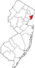 | |
| Borough | ||
| Towns | ||
| Townships | ||