M49 motorway
| |
|---|---|
| Route information | |
| Length: | 5.0 mi (8.0 km) |
| Existed: | 1996 – present |
| Major junctions | |
| North end: | Redwick |
|
M4 motorway M5 motorway | |
| South end: | Lawrence Weston |
| Road network | |

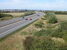
The M49 motorway is a 5-mile (8 km) motorway west of Bristol, England, that forms a link between the M5 motorway at Junction 18, and the Second Severn Crossing, on the M4 motorway at Junction 22. It was constructed in 1996,[1] at the same time as the bridge and is unique as it is only accessible from other motorways.
Original plans provided for an intermediate junction with the A403, to serve an expanded industrial area and Severn Beach, but neither has come to fruition.[2] The M49 is anomalously numbered, as it is entirely to the south of the M4 and should therefore begin with a 3.[3]
Route
The M49 begins at junction 18A of the M5 and then heads roughly north and northwest before it reaches its terminal junction with the M4 at junction 22, just before the Second Severn Crossing. It cuts journey times for traffic to and from Avonmouth docks, Central and southern Bristol and South West England.
Compared to driving via the M4/M5 interchange, using the M49 cuts the distance travelled by 6.2 miles. Having a two-way grade separated roundabout junction with the M4, it also fulfils the dual role of providing a bypass for the busy stretch of the M5 between the Avonmouth Bridge and the M4 in case of that route being shut.
Junctions
Data from driver location signs are used to provide distance and carriageway identifier information.[4]
| M49 motorway junctions | |||||
| miles | km | North-west bound exits (B carriageway) | Junction | South-east bound exits (A carriageway) | |
|---|---|---|---|---|---|
| 0.0 | 0.0 | Bristol, London M4(E) | M4 J22 terminus |
The South West, Avonmouth M49 | |
| South Wales, Cardiff, Newport M4(W) | Start of motorway | ||||
| 5.3 | 8.5 | Start of motorway | Terminus A4, M5 J18 & J18A |
Avonmouth, Bristol, Airport A4 | |
| South Wales, Cardiff, Newport (M4(W)) M49 | The South West, Weston-s-Mare, M5 | ||||
Notes
| |||||
| 1.000 mi = 1.609 km; 1.000 km = 0.621 mi | |||||
Information above gathered from Advanced Direction Signs May 2011
See also
References
- ↑ CBRD Motorway Database – M49
- ↑ Pathetic Motorways – M49
- ↑ Pathetic Motorways – M49
- ↑ "Traffic England Live Traffic Condition Map (selected Popups)". Highways Agency. Retrieved 2009-11-11.
External links
| Great Britain | .svg.png) | |||||||
|---|---|---|---|---|---|---|---|---|
| Northern Ireland | ||||||||
| Former | ||||||||
| Unbuilt | ||||||||
| Proposed | ||||||||
| Related articles | ||||||||
| ||||||||