M275 motorway
| |
|---|---|
| Route information | |
| Length: | 2.0 mi (3.2 km) |
| Existed: | 1976 – present |
| Major junctions | |
| From: | Wymering |
|
M27 motorway | |
| To: | Portsmouth |
| Road network | |

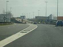
The M275 is a 2-mile (3.2 km) long, dual three-lane motorway in Hampshire, southern England. It is the principal route for entering and leaving Portsmouth. It continues as the A3 into Portsmouth, and meets the M27 at its northern terminus. From the motorway, there are scenic views over Portsmouth harbour, and the Sails of the South between the two carriageways.
The M275 is one of few motorways in England which is not the responsibility of the Highways Agency. It is managed by Portsmouth City Council from the point where the slip roads to the M27 end. The M275 was not built with a full hard shoulder. For its entire length, a narrow verge is maintained, although there is space available for a full width shoulder. Instead, drivers are warned on entry from the A3 and M27 of the lack of hard shoulder, with signs saying "no hard shoulder for 2 miles".
History
The motorway was opened throughout its entire length in 1976. A junction was originally planned for a new development in the Tipner area of Portsmouth, known as the Gateway Project,[1] which was shelved at the time. The junction's construction was abandoned primarily because planners realised that it would breach regulations that there must be a minimum of 1.25 miles (2.01 km) between motorway junctions. Before construction was halted, significant work had been carried out, including four incomplete slip roads with no road surfacing, two bridges above the site for the main roundabout, and realignment of Tipner Lane so that it served the roundabout. In 2001 the Sails of the South was unveiled close to the site of the missing junction. 2005 saw Portsmouth City Council carry out refurbishments to gantry mounted signs on approach to the M27 junction, new signage was stuck over old signage, and was significantly smaller and disproportionate to the previous layout. Incorrect lane illustrations, lack of adequate route information, and increased difficulty to read at a long distance lead to driver frustration and confusion.
In 2005, the Tipner Gateway Project was resurrected along with plans for a junction. As previously, preparatory works have been carried out for the junction. Due to the regulations regarding junction spacing, the speed limit on the main carriageway of the M275 has been reduced to 60 mph (97 km/h), and 50 mph (80 km/h) on the slip roads and from the southern end of Mile End Road to the Kingston Crescent Junction. The latter junction is to be renamed Junction 2, with the new Tipner Junction becoming Junction 1. Most of the road signs have been replaced and the M27/M275 interchange has been remodelled to make it easier for drivers, including splitting one lane into two, although this has meant that some of the overhead gantry signs are now redundant. Completion of the junction was achieved April 2014. The junction is now to Tipner West and a large park and ride site for over 600 cars alongside the junction.
Junctions
| M275 motorway | |||
| Northbound exits | Junction | Southbound exits | Coordinates |
| Southampton, Fareham M27(W) Chichester, Brighton (A27), London (A3(M)) M27(E) |
Terminus (M27 J12) |
Portsmouth (W), Ferries M275 | 50°50′15″N 1°04′59″W / 50.83757°N 1.08293°W |
| Cosham A27 | Start of motorway | ||
| Tipner (W), Park and Ride | J1 | Tipner (W), Park and Ride | |
| Start of motorway | Terminus J2 |
Cruise and Cross Channel Ferries, North End | 50°48′34″N 1°05′12″W / 50.80957°N 1.08670°W |
| Cross Channel Ferries, Hilsea North End, Stamshaw A3 (A27) |
Road continues as A3 to Portsmouth (W), Isle of Wight Ferries and Naval Base | ||
See also
References
External links
| Wikimedia Commons has media related to M275 motorway. |
- Portsmouth City Council – M275 Tipner Scheme
- Portsmouth City Council – M275 Tipner Updates
- Pathetic Motorways – M275
| Great Britain | .svg.png) | |||||||
|---|---|---|---|---|---|---|---|---|
| Northern Ireland | ||||||||
| Former | ||||||||
| Unbuilt | ||||||||
| Proposed | ||||||||
| Related articles | ||||||||
| ||||||||