M-99 (Michigan highway)
| ||||||||||
|---|---|---|---|---|---|---|---|---|---|---|
 | ||||||||||
| Route information | ||||||||||
| Maintained by MDOT | ||||||||||
| Length: | 86.058 mi[1] (138.497 km) | |||||||||
| Existed: | 1940[2][3] – present | |||||||||
| Major junctions | ||||||||||
| South end: |
| |||||||||
|
| ||||||||||
| North end: |
| |||||||||
| Location | ||||||||||
| Counties: | Hillsdale, Calhoun, Jackson, Eaton, Ingham | |||||||||
| Highway system | ||||||||||
| ||||||||||

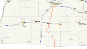
M-99 is a north–south state trunkline highway in the Lower Peninsula of the US state of Michigan. It runs from the Ohio state border, where it connects to State Route 15 (SR 15), north to Lansing, where it terminates at a junction with Interstate 496 (I-496) and the Capitol Loop. The highway mainly serves local communities along the route as it passes through farm lands in the southern part of the state. One segment is routed concurrently with US Highway 12 (US 12) in Jonesville while the northern end runs through urban areas on a street named for Martin Luther King, Jr. in Lansing.
The current highway is the third to carry the M-99 designation. The others were located near Lake Michigan near Muskegon in the Lower Peninsula and Gulliver in the Upper Peninsula in the 1920s and 1930s. The current highway was first designated as parts of M-34 and M-64 in 1919. These numbers were later dropped in favor of an M-9 designation in 1929. For part of 1934, a loop route was designated M-158 in Hillsdale County that was used for a rerouted M-9 in the area. The M-99 designation was applied to the highway in 1940. Since then, the state has completed paving twice; one segment was returned to gravel surface for two years in the 1950s. The southern section in Hillsdale County was rerouted in the 1960s, and sections were converted into divided highways in the late 1970s.
Route description
SR 15 ends at the Michigan state line just north of Pioneer, Ohio, where it becomes M-99. The roadway travels northward from the state line on Pioneer Road, through mostly agricultural areas of Hillsdale County before reaching a junction with M-34 just west of Osseo. The trunkline turns westward on Hudson Road, which curves to the north around Baw Beese Lake just southeast of Hillsdale. M-99 passes through Hillsdale on a northwest course on Broad Street and Carlton Road, passing just a few blocks to the west of Hillsdale College. After leaving town, the road bends to the north as Olds Street as it runs parallel to the St. Joseph River to Jonesville. In that community, M-99 intersects US 12. The two highways run concurrently through Jonesville for less than half a mile (0.8 km) before M-99 returns to its northwesterly course. It leaves the town toward Litchfield continuing parallel to the river.[4][5]

In Litchfield, M-99 enters the town from the southeast, passing near downtown where it meets the northern terminus of M-49. The highway leaves Litchfield heading northwest on Homer Road for a few miles before bending to the north as it crosses into Calhoun County. The trunkline passes through more farmland as it runs toward Homer on Hillsdale Street. In Homer, after passing through a roundabout, M-99 meets up with M-60 and the two highways run concurrently through the town to the northeast. The road briefly splits into a divided highway near the end of the concurrency. M-99 heads north, while M-60 continues eastward. From here, M-99 continues northward on 28 Mile Road toward the city of Albion. After crossing the Kalamazoo River in downtown, M-99 merges with Business Loop I-94 (BL I-94). M-99 continues east concurrently with the business loop on Michigan Avenue passing near Albion College before heading back north to an interchange with I-94 at exit 124; this interchange marks the end of BL I-94 and M-99 continues northward on Eaton Rapids Road.[4][5]
M-99 heads north through farmland to the village of Springport where it turns eastward along Main Street as it passes through the town. The highway continues easterly on Eaton Rapids Road before turning northward to cross into Eaton County. Shortly after crossing the county line, M-50 comes in from the southwest to meet up with M-99. The two highways travel together into Eaton Rapids. Together they form Main Street in the city before they separate on the north side of town. M-50 leaves to the northwest as Dexter Road, and M-99 continues to the northeast as Canal and Michigan streets. For the next few miles, the trunkline splits into a divided highway and runs parallel to the general course of the Grand River. M-99 crosses the river southeast of Diamondale after the opposing directions merge back together as an undivided highway. North of the river crossing, M-99 meets I-96 at the latter's exit 101 on the southern border of Lansing.[4][5]
From I-96, the road continues north through residential neighborhoods into Lansing as Martin Luther King Jr. Boulevard. The highway travels northeasterly through the southern side of the capital city, as far as Jolly Road. There it turns northward through the Old Everett Neighborhood. The street is bordered by commercial properties in this area. M-99 widens into a boulevard south of the intersection with Mount Hope Avenue before crossing the Grand River. North of the river, the highway is bordered by the site of the former Lansing Car Assembly plant,[4][5] which for a century produced Oldsmobiles and other GM cars.[6] M-99 ends at a junction with I-496 just north of the assembly plant area at exit 5; MLK Boulevard continues north from this interchange as the Capitol Loop.[4][5]
M-99 is maintained by the Michigan Department of Transportation (MDOT) like other state highways in Michigan. As a part of these maintenance responsibilities, the department tracks the volume of traffic that uses the roadways under its jurisdiction. These volumes are expressed using a metric called annual average daily traffic, which is a statistical calculation of the average daily number of vehicles on a segment of roadway. MDOT's surveys in 2010 showed that the highest traffic levels along M-99 were the 32,262 vehicles daily north of Mount Hope Avenue in Lansing; the lowest counts were the 2,300 vehicles per day between the state line and the M-34 junction.[7] No section of M-99 has been listed on the National Highway System,[8] a network of roads important to the country's economy, defense, and mobility.[9]
History
Previous designations
When the state highway system was originally signed in 1919,[10] M-99 was designated on a road between the Lake Michigan shoreline and M-11 (now US 31) between Muskegon and Hart.[11] This highway was decommissioned in 1929.[12][13] In 1931, M-99 was designated on a gravel road in the Upper Peninsula from US 2 just east of Gulliver) to Port Inland on Lake Michigan.[14][15] This highway was decommissioned as well in 1939.[2][16]
Current designation
In 1919, the highway that is now M-99 was first signed as M-64 from the Ohio state line to Hillsdale and as M-34 from Hillsdale to the Litchfield area.[11] In 1924, the western terminus of M-34 was extended to Homer where it terminated at M-60.[17][18] Just a few years later, in 1926, the western terminus was truncated, to end at Hillsdale, with the remainder to Jonesville becoming an extension of the M-64.[19]
| |
|---|---|
| Location: | Ohio state line to Lansing |
| Length: | 102.266 mi[1] (164.581 km) |
| Existed: | 1929[12][13]–1940[2][3] |
| |
|---|---|
| Location: | Hillsdale County |
| Length: | 3.285 mi[1] (5.287 km) |
| Existed: | Early–Late 1934[20][21][22] |
In 1929, this version of M-64 was renumbered M-9.[12][13] In 1934, M-9 traveled on Pioneer Road in Hillsdale County, from the Ohio border before turning west on Burt Road, north on Clark Road, west on Montgomery Road then north onto Hillsdale Road. During this time a loop was planned to continue north from the corner of Pioneer and Burt Roads to Montgomery Road where it turned west and met back up with M-9 at Clark Road. This short loop was designated M-158, however later in the year the routing of M-9 was shifted onto the M-158 alignment, eliminating that route.[20][21][22] By the middle of 1936, the highway was extended northward to end in Lansing.[23] The M-9 designation was replaced with M-99 in 1940.[2][3]
By 1947, M-99 was completely paved.[24][25] One segment between Litchfield and Homer was converted back to gravel surface in 1952;[26][27] a change that was reverted two years later.[28][29] By 1960, the former US 12/M-99 concurrency through Albion was redesignated Business US 12 through the city when the I-94/US 12 freeway was completed.[30][31] Within a year, that business loop was redesignated BL I-94 when the US 12 designation was removed from the freeway and applied to the former US 112; at the same time, the US 112/M-99 concurrency in Jonesville became US 12/M-99 as well.[31][32]
A new alignment of M-99 highway was opened from the Ransom area north to Osseo in 1966; the western terminus of M-34 was scaled back to end at the new highway near Osseo and M-99 supplanted M-34 from Osseo to Hillsdale.[33][34] The divided highway section of M-99 was opened north of Eaton Rapids in 1979.[35][36]
Major intersections
| County | Location | mi[1] | km | Destinations | Notes |
|---|---|---|---|---|---|
| Hillsdale | Amboy Township | 0.000 | 0.000 | Ohio state line | |
| Jefferson Township | 12.633 | 20.331 | |||
| Jonesville | 22.895 | 36.846 | Southern end of US 12 concurrency | ||
| 23.234 | 37.391 | Northern end of US 12 concurrency | |||
| Litchfield | 30.187 | 48.581 | |||
| Calhoun | Homer | 38.310 | 61.654 | Western end of M-60 concurrency | |
| Albion Township– Homer Township | 41.520 | 66.820 | Eastern end of M-69 concurrency | ||
| Albion | 47.595 | 76.597 | Western end of BL I-94 concurrency | ||
| Jackson | Parma Township | 50.415 | 81.135 | Western end of BL I-94 concurrency; exit 124 on I-94 | |
| Eaton | Springport Township | 63.364 | 101.974 | Southern end of M-50 concurrency | |
| Eaton Rapids | 69.287 | 111.507 | Western terminus of M-188 | ||
| 69.786 | 112.310 | Northern end of M-50 concurrency | |||
| Ingham | Lansing | 81.407– 81.426 | 131.012– 131.042 | Exit 101 on I-96 | |
| 86.039– 86.058 | 138.466– 138.497 | Northern terminus of M-99 and western terminus of the Capitol Loop; exit 5 on I-496 | |||
1.000 mi = 1.609 km; 1.000 km = 0.621 mi
| |||||
See also
 Michigan Highways portal
References
- 1 2 3 4 Michigan Department of Transportation & Michigan Center for Shared Solutions and Technology Partnerships (2009). MDOT Physical Reference Finder Application (Map). Michigan Department of Transportation. Retrieved May 16, 2012.
- 1 2 3 4 Michigan State Highway Department & Rand McNally (December 1, 1939). Official Michigan Highway Map (Map) (Winter ed.). [c. 1:850,000]. Lansing: Michigan State Highway Department. §§ D8, L11–N11. OCLC 12701143.
- 1 2 3 Michigan State Highway Department & Rand McNally (April 15, 1940). Official Michigan Highway Map (Map) (Spring ed.). [c. 1:850,000]. Lansing: Michigan State Highway Department. § L11–N11. OCLC 12701143.
- 1 2 3 4 5 Michigan Department of Transportation (2011). Pure Michigan: State Transportation Map (Map). c. 1:975,000. Lansing: Michigan Department of Transportation. §§ L11–N11. OCLC 42778335, 786008212.
- 1 2 3 4 5 Google (May 16, 2012). "Overview Map of M-99" (Map). Google Maps. Google. Retrieved May 16, 2012.
- ↑ Martin, Tim (December 24, 2006). "New Factory Is Reshaping GM's Future: A Smaller, State-of-the-Art Auto Plant Has Been Good for the Company and the City of Lansing, Mich.". The Wisconsin State Journal. Madison. Associated Press. ISSN 0749-405X. Retrieved May 16, 2012 – via HighBeam Research.
- ↑ Bureau of Transportation Planning (2008). "Traffic Monitoring Information System". Michigan Department of Transportation. Retrieved May 16, 2011.
- ↑ Michigan Department of Transportation (April 23, 2006). National Highway System, Michigan (PDF) (Map). Scale not given. Lansing: Michigan Department of Transportation. Retrieved October 7, 2008.
- ↑ Natzke, Stefan; Neathery, Mike & Adderly, Kevin (June 20, 2012). "What is the National Highway System?". National Highway System. Federal Highway Administration. Retrieved July 1, 2012.
- ↑ "Michigan May Do Well Following Wisconsin's Road Marking System". The Grand Rapids Press. September 20, 1919. p. 10.
- 1 2 Michigan State Highway Department (July 1, 1919). State of Michigan (Map). Scale not given. Lansing: Michigan State Highway Department. Lower Peninsula sheet. OCLC 15607244.
- 1 2 3 Michigan State Highway Department (May 1, 1929). Official Highway Service Map (Map). [c. 1:810,000]. Lansing: Michigan State Highway Department. OCLC 12701195, 79754957.
- 1 2 3 Michigan State Highway Department & H.M. Gousha (January 1, 1930). Official Highway Service Map (Map). [c. 1:810,000]. Lansing: Michigan State Highway Department. OCLC 12701195, 79754957.
- ↑ Michigan State Highway Department & Rand McNally (May 15, 1931). Official Highway Service Map (Map). [c. 1:840,000]. Lansing: Michigan State Highway Department. § D8. OCLC 12701053.
- ↑ Michigan State Highway Department & Rand McNally (October 1, 1931). Official Highway Service Map (Map). [c. 1:840,000]. Lansing: Michigan State Highway Department. § D8. OCLC 12701053.
- ↑ Michigan State Highway Department & Rand McNally (April 15, 1939). Official Michigan Highway Map (Map) (Summer ed.). [c. 1:850,000]. Lansing: Michigan State Highway Department. § D8. OCLC 12701143.
- ↑ Michigan State Highway Department (May 15, 1924). Official Highway Condition Map (Map). [c. 1:823,680]. Lansing: Michigan State Highway Department.
- ↑ Michigan State Highway Department (October 1, 1924). Official Highway Condition Map (Map). [c. 1:823,680]. Lansing: Michigan State Highway Department.
- ↑ Michigan State Highway Department (December 1, 1926). Official Highway Condition Map (Map). [c. 1:823,680]. Lansing: Michigan State Highway Department.
- 1 2 Michigan State Highway Department & Rand McNally (May 1, 1934). Official Michigan Highway Map (Map). [c. 1:850,000]. Lansing: Michigan State Highway Department. § N11. OCLC 12701143.
- 1 2 Michigan State Highway Department & Rand McNally (July 1, 1934). Official Michigan Highway Map (Map). [c. 1:850,000]. Lansing: Michigan State Highway Department. § N11. OCLC 12701143.
- 1 2 Michigan State Highway Department & Rand McNally (September 1, 1934). Official Michigan Highway Map (Map). [c. 1:850,000]. Lansing: Michigan State Highway Department. § N11. OCLC 12701143.
- ↑ Michigan State Highway Department & Rand McNally (June 1, 1936). Official Michigan Highway Map (Map). [c. 1:850,000]. Lansing: Michigan State Highway Department. §§ L11–N11. OCLC 12701143.
- ↑ Michigan State Highway Department (July 1, 1946). Michigan Official Highway Map (Map). [c. 1:918,720]. Lansing: Michigan State Highway Department. §§ L11–N11. OCLC 12701120, 613361131.
- ↑ Michigan State Highway Department (May 1, 1947). Official Highway Map (Map). [c. 1:918,720]. Lansing: Michigan State Highway Department. § N11. OCLC 12701120, 494733404.
- ↑ Michigan State Highway Department (April 15, 1952). Official Highway Map (Map). [c. 1:918,720]. Lansing: Michigan State Highway Department. § N11. OCLC 12701120.
- ↑ Michigan State Highway Department (October 1, 1952). Official Highway Map (Map). [c. 1:918,720]. Lansing: Michigan State Highway Department. § N11. OCLC 12701120.
- ↑ Michigan State Highway Department (April 15, 1954). Official Highway Map (Map). [c. 1:918,720]. Lansing: Michigan State Highway Department. § N11. OCLC 12701120.
- ↑ Michigan State Highway Department (October 1, 1954). Official Highway Map (Map). [c. 1:918,720]. Lansing: Michigan State Highway Department. § N11. OCLC 12701120.
- ↑ Michigan State Highway Department (1958). Official Highway Map (Map). [c. 1:918,720]. Lansing: Michigan State Highway Department. § M11. OCLC 12701120, 51856742. (Includes all changes through July 1, 1958)
- 1 2 Michigan State Highway Department (1960). Official Highway Map (Map). [c. 1:918,720]. Lansing: Michigan State Highway Department. §§ M11–N11. OCLC 12701120, 81552576. (Includes all changes through July 1, 1960)
- ↑ Michigan State Highway Department (1961). Official Highway Map (Map). [c. 1:918,720]. Lansing: Michigan State Highway Department. §§ M11–N11. OCLC 12701120, 51857665. (Includes all changes through July 1, 1961)
- ↑ Michigan Department of State Highways (1966). Official Highway Map (Map). [c. 1:918,720]. Lansing: Michigan Department of State Highways. § N11. OCLC 12701120.
- ↑ Michigan Department of State Highways (1967). Michigan Water-Winter Wonderland: Official Highway Map (Map). [c. 1:918,720]. Lansing: Michigan Department of State Highways. § N11. OCLC 12701120.
- ↑ Michigan Department of State Highways and Transportation (1979). Michigan, Great Lake State: Official Transportation Map (Map) (1978–79 ed.). c. 1:918,720. Lansing: Michigan Department of State Highways and Transportation. § M11. OCLC 12701177.
- ↑ Michigan Department of Transportation (1980). Michigan, Great Lake State: Official Transportation Map (Map) (1980–81 ed.). c. 1:918,720. Lansing: Michigan Department of Transportation. § M11. OCLC 12701177, 606211521.
External links