Mürtschenstock
For other uses of Fulen, see Fulen (disambiguation). For other uses of Ruchen, see Ruchen (disambiguation). For other uses of Stock, see Stock (disambiguation).
| Mürtschenstock | |
|---|---|
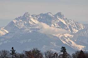 The Mürtschenstock seen from the Pfannenstiel (west side), from left (north) to right (south) the peaks Stock, Fulen, and Ruchen (highest) | |
| Highest point | |
| Peak | Ruchen |
| Elevation | 2,441 m (8,009 ft) |
| Prominence | 601 m (1,972 ft) [1] |
| Coordinates | 47°4′10.4″N 9°8′41.3″E / 47.069556°N 9.144806°ECoordinates: 47°4′10.4″N 9°8′41.3″E / 47.069556°N 9.144806°E |
| Geography | |
 Mürtschenstock Location in Switzerland | |
| Location | Glarus |
| Country | Switzerland |
| Parent range | Glarus Alps |
| Topo map | Swiss Federal Office of Topography swisstopo |
The Mürtschenstock is a mountain massif of the Glarus Alps, overlooking the Walensee in the canton of Glarus. It is composed of several summits, of which the highest (named Ruchen) has an elevation of 2,441 metres above sea level. The two other main summits are the Stock (2,390 m) and the Fulen (2,410 m) .

View of the Mürtschenstock from across the Walensee (north side)
References
External links
 Media related to Mürtschenstock at Wikimedia Commons
- Mürtschenstock on Hikr
This article is issued from Wikipedia - version of the 5/9/2016. The text is available under the Creative Commons Attribution/Share Alike but additional terms may apply for the media files.