Mühlenbecker Land
Mühlenbecker Land is a municipality in the Oberhavel district, in Brandenburg, Germany.
History
The municipality shared its borders partly with the former West Berlin, and so during the period 1961-1990 it was separated from it by the Berlin Wall.
Demography
Development of Population since 1875 within the Current Boundaries (Blue Line: Population; Dotted Line: Comparison to Population Development of Brandenburg state; Grey Background: Time of Nazi rule; Red Background: Time of Communist rule)
Recent Population Development (Blue Line) and Forecasts
Mühlenbecker Land:
Population development within the current boundaries[2]
| Year |
Population |
|
|
|---|
| 1875 | 2 247 |
| 1890 | 2 527 |
| 1910 | 3 514 |
| 1925 | 3 977 |
| 1933 | 5 800 |
| 1939 | 7 336 |
| 1946 | 7 814 |
| 1950 | 7 943 |
| 1964 | 7 459 |
| 1971 | 7 382 |
|
|
| Year |
Population |
|
|
|---|
| 1981 | 6 817 |
| 1985 | 6 703 |
| 1989 | 6 349 |
| 1990 | 6 264 |
| 1991 | 6 197 |
| 1992 | 6 225 |
| 1993 | 6 508 |
| 1994 | 6 474 |
| 1995 | 6 765 |
| 1996 | 6 996 |
|
|
| Year |
Population |
|
|
|---|
| 1997 | 7 844 |
| 1998 | 8 995 |
| 1999 | 9 992 |
| 2000 | 10 458 |
| 2001 | 10 956 |
| 2002 | 11 291 |
| 2003 | 11 878 |
| 2004 | 12 332 |
| 2005 | 12 855 |
| 2006 | 13 213 |
|
|
| Year |
Population |
|
|
|---|
| 2007 | 13 608 |
| 2008 | 13 780 |
| 2009 | 13 888 |
| 2010 | 14 071 |
| 2011 | 14 075 |
| 2012 | 14 293 |
|
|
Detailed data sources are to be found in the Wikimedia Commons.[3]
References


 Lake "Mühlenbecker See"
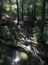
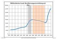 Development of Population since 1875 within the Current Boundaries (Blue Line: Population; Dotted Line: Comparison to Population Development of Brandenburg state; Grey Background: Time of Nazi rule; Red Background: Time of Communist rule)
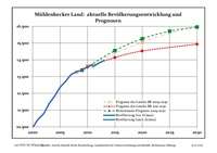 Recent Population Development (Blue Line) and Forecasts