Mörbylånga Municipality
| Mörbylånga Municipality Mörbylånga kommun | ||
|---|---|---|
| Municipality | ||
| ||
 | ||
| Country | Sweden | |
| County | Kalmar County | |
| Seat | Mörbylånga | |
| Area[1] | ||
| • Total | 3,043.42 km2 (1,175.07 sq mi) | |
| • Land | 666.79 km2 (257.45 sq mi) | |
| • Water | 2,376.63 km2 (917.62 sq mi) | |
| Area as of January 1, 2014. | ||
| Population (June 30, 2016)[2] | ||
| • Total | 14,710 | |
| • Density | 4.8/km2 (13/sq mi) | |
| Time zone | CET (UTC+1) | |
| • Summer (DST) | CEST (UTC+2) | |
| ISO 3166 code | SE | |
| Province | Öland | |
| Municipal code | 0840 | |
| Website | www.morbylanga.se | |

Mörbylånga Municipality (Mörbylånga kommun) is a municipality in Kalmar County, in south-eastern Sweden, located on the island of Öland in the Baltic Sea. The seat is located in the town of Mörbylånga, while the largest town is Färjestaden.
The present municipality, making up the southern part of Öland, was formed in 1974. The eighteen original entities (as of 1863) had during the nationwide subdivision reform of 1952 been regrouped into three larger units. Ottenby was amalgamated with Mörbylånga in 1967 and 1974 Torslunda was added.
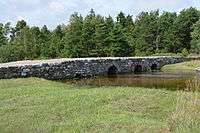
Mörbylånga Municipality contains several ancient remains, just like the northern Öland municipality of Borgholm. All in all, there are about 20 hillforts on Öland. The most notable in southern Öland is the fortress Eketorp.
The entire southern part of the island has been listed as a UNESCO World Heritage Site, basically the whole municipality of Mörbylånga. The reason is that the climate and bedrock has made the area populated and cultivated for several thousands of years. Unlike the geology on the eastern mainland province of Småland there are scarcely any forests on Öland, so people can conduct agriculture.
The southern parts of Öland also contain certain wildlife areas. Many migratory birds halt here on their way north or south. Especially the southernmost outpost, the lighthouse Långe Jan (Tall John) is visited by many birdwatchers every day, as many birds flock here until setting away over the ocean.
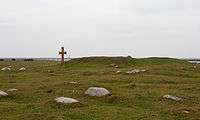
One fourth of the municipality consists of the nature area, Stora Alvaret, a unique alvar nature area containing by many endemic and rare plants not found anywhere else. One can see several kilometers of just plains and the sky.
Localities
There are 9 urban areas (also called a Tätort or locality) in Mörbylånga Municipality.
In the table the localities are listed according to the size of the population as of December 31, 2005. The municipal seat is in bold characters.
| # | Locality | Population |
|---|---|---|
| 1 | Färjestaden | 4,636 |
| 2 | Mörbylånga | 1,784 |
| 3 | Skogsby | 528 |
| 4 | Algutsrum | 499 |
| 5 | Degerhamn | 372 |
| 6 | Vickleby | 310 |
| 7 | Gårdby | 262 |
| 8 | Arontorp | 231 |
| 9 | Kastlösa | 208 |
Mörbylånga and surroundings

_0501.jpg)


References
- ↑ "Statistiska centralbyrån, Kommunarealer den 1 januari 2014" (Microsoft Excel) (in Swedish). Statistics Sweden. Retrieved 2014-04-18.
- ↑ "Folkmängd i riket, län och kommuner 30 juni 2016" (in Swedish). Statistics Sweden. August 17, 2016. Retrieved August 17, 2016.
External links
- Mörbylånga Municipality - Official site
- Southern Öland - Tourism page (in Swedish, English and German)
| Municipalities |  | |
|---|---|---|
| Parks and reserves | ||
| Places of interest | ||
| Churches | ||
Municipalities and seats of Kalmar County | ||
|---|---|---|
| Municipalities | ||
| Municipal seats | ||
Coordinates: 56°31′N 16°23′E / 56.517°N 16.383°E