Métabetchouan–Lac-à-la-Croix, Quebec
| Métabetchouan–Lac-à-la-Croix | |
|---|---|
| City | |
 | |
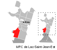 | |
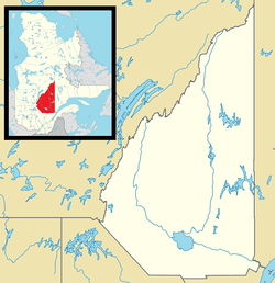 Métabetchouan –Lac-à-la-Croix Location in Lac-Saint-Jean Quebec. | |
| Coordinates: 48°26′N 71°52′W / 48.433°N 71.867°WCoordinates: 48°26′N 71°52′W / 48.433°N 71.867°W[1] | |
| Country |
|
| Province |
|
| Region | Saguenay–Lac-Saint-Jean |
| RCM | Lac-Saint-Jean-Est |
| Settled | 1861 |
| Constituted | January 6, 1999 |
| Government[2] | |
| • Mayor | Lili Simard |
| • Federal riding | Lac-Saint-Jean |
| • Prov. riding | Lac-Saint-Jean |
| Area[2][3] | |
| • Total | 193.80 km2 (74.83 sq mi) |
| • Land | 186.70 km2 (72.09 sq mi) |
| Population (2011)[3] | |
| • Total | 4,097 |
| • Density | 21.9/km2 (57/sq mi) |
| • Pop 2006-2011 |
|
| • Dwellings | 2,053 |
| Time zone | EST (UTC−5) |
| • Summer (DST) | EDT (UTC−4) |
| Postal code(s) | G8G 1A1 |
| Area code(s) | 418 and 581 |
| Highways |
|
| Website |
www metabetchouan |
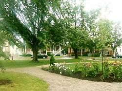
Métabetchouan–Lac-à-la-Croix is a city in Quebec, Canada, in the Saguenay–Lac-Saint-Jean region.
The city consists of the population centres of Métabetchouan, on the shores of Lac Saint-Jean at the mouth of the small Couchepaganiche River, and Lac-à-la-Croix, a few kilometres to the east on Cross Lake.
History

Historically the territory of the indigenous Innu, the first European, Jesuit Jean de Quen, visited the place in 1647, followed by Charles Albanel in 1671, during the meeting of twenty Indian nations. Five years later in 1676, a trading post and mission were established there. But real colonization only began after the proclamation of Métabetchouan Township in 1857, and the first settlers arrived from the South Shore and Bagotville in 1861. That same year, Stanislas Drapeau reported the presence of 154 people including 36 "savages" in Métabetchouan Township.[4][5]
The place was first called Saint-Jérôme, in honour of Jérôme Demers (1774-1853), vicar general of the Bishop of Quebec (1825-1853). In 1870, it was nearly destroyed by a great fire, that only spared some twenty houses. In 1872, the Parish Municipality of Saint-Jérôme was formed, and in 1898, the village itself separated and was incorporated as the Village Municipality of Saint-Jérôme.[5]
As for Lac-à-la-Croix, the first settlers came in 1864, and by 1910, it had some 800 inhabitants. Its parish was established in March 1911 and in December that same year, it was incorporated as the Parish Municipality of Sainte-Croix. In 1953, the village itself separated and formed the Village Municipality of Sainte-Croix, later renamed to Lac-à-la-Croix (French for "Lake at the Cross"). It was named after the adjacent lake where, according to popular thought, a cross that was planted on its shores by François de Crespieul in the 17th century. But this has been proven untrue since missionaries never went through this place. The lake was probably named for having a resemblance to a cross.[6]
In 1975, the Parish and Village Municipalities of Saint-Jérôme merged to form the new City of Métabetchouan, named after the township and the nearby Métabetchouane River. The following year, the Parish Municipality of Sainte-Croix and the Village Municipality of Lac-à-la-Croix also merged to form the Municipality of Lac-à-la-Croix. And on January 6, 1999, the City of Métabetchouan and the Municipality of Lac-à-la-Croix amalgamated to form the new city of Métabetchouan-Lac-à-la-Croix.[5][6]
Demographics
Population trend:[7]
- Population in 2011: 4097 (2006 to 2011 population change: 0.3%)
- Population in 2006: 4084
- Population in 2001: 4198
- Population total in 1996: 4487
- Métabetchouan (ville): 3474
- Lac-à-la-Croix (municipality): 1013
- Population in 1991:
- Métabetchouan (ville): 3379
- Lac-à-la-Croix (municipality): 971
Private dwellings occupied by usual residents: 1,690 (total dwellings: 2,053)
Mother tongue:[8]
- English as first language: 0%
- French as first language: 99.7%
- English and French as first language: 0%
- Other as first language: 0.3%
See also
References
- ↑ Reference number 351939 of the Commission de toponymie du Québec (French)
- 1 2 Ministère des Affaires municipales, des Régions et de l'Occupation du territoire - Répertoire des municipalités: Métabetchouan–Lac-à-la-Croix
- 1 2 "Métabetchouan–Lac-à-la-Croix census profile". 2011 Census data. Statistics Canada. Retrieved 2010-11-09.
- ↑ "Tourisme - Histoire commune" (in French). Ville de Métabetchouan-Lac-à-la-Croix. Retrieved 2010-11-08.
- 1 2 3 "Métabetchouan (Ville)" (in French). Commission de toponymie du Québec. Retrieved 2010-11-08.
- 1 2 "Lac-à-la-Croix (Municipalité)" (in French). Commission de toponymie du Québec. Retrieved 2010-11-08.
- ↑ Statistics Canada: 1996, 2001, 2006, 2011 census
- ↑ "Métabetchouan–Lac-à-la-Croix community profile". 2006 Census data. Statistics Canada. Retrieved 2010-11-09.
External links
![]() Media related to Métabetchouan–Lac-à-la-Croix at Wikimedia Commons
Media related to Métabetchouan–Lac-à-la-Croix at Wikimedia Commons
 |
Lac Saint-Jean | Saint-Gédéon | | |
| Desbiens | |
Hébertville | ||
| ||||
| | ||||
| Saint-André-du-Lac-Saint-Jean | Belle-Rivière |
| Cities | |
|---|---|
| Municipalities | |
| Parishes | |
| Villages | |
| Unorganized territories | |
| |