Målselv
| Målselv kommune Málatvuomi suohkan | |||
|---|---|---|---|
| Municipality | |||
|
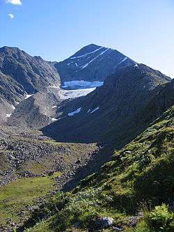
View of the mountain Istind on the Bardu-Målselv border | |||
| |||
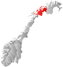
 Målselv within Troms | |||
| Coordinates: 68°58′30″N 19°3′52″E / 68.97500°N 19.06444°ECoordinates: 68°58′30″N 19°3′52″E / 68.97500°N 19.06444°E | |||
| Country | Norway | ||
| County | Troms | ||
| District | Midt-Troms | ||
| Administrative centre | Moen | ||
| Government | |||
| • Mayor (2011) | Helene Rognli (H) | ||
| Area | |||
| • Total | 3,321.72 km2 (1,282.52 sq mi) | ||
| • Land | 3,206.97 km2 (1,238.22 sq mi) | ||
| • Water | 114.75 km2 (44.31 sq mi) | ||
| Area rank | 10 in Norway | ||
| Population (2012) | |||
| • Total | 6,599 | ||
| • Rank | 147 in Norway | ||
| • Density | 2/km2 (5/sq mi) | ||
| • Change (10 years) | -3.7 % | ||
| Demonym(s) | Målselvdøl[1] | ||
| Time zone | CET (UTC+1) | ||
| • Summer (DST) | CEST (UTC+2) | ||
| ISO 3166 code | NO-1924 | ||
| Official language form | Neutral | ||
| Website |
www | ||
|
| |||

Målselv (Northern Sami: Málatvuomi suohkan) is a municipality in Troms county, Norway. The administrative centre of the municipality is the village of Moen. The main commercial centre of the municipality is the Bardufoss area (including Andselv, Andslimoen, and Heggelia. Other villages include Alappmoen, Fossmoen, Holmen, and Skjold. Besides bordering Sweden to the east and the ocean (Malangen fjord) to the northwest, it borders the municipalities of Balsfjord, Storfjord, Bardu, Sørreisa, and Lenvik.
General information
The municipality of Maalselven was established in 1849 when it was separated from the large municipality of Lenviken. The initial population of Maalselven was 2,616. In 1891, some parts of the Målsnes area (population: 30) were transferred to neighboring Malangen. On 1 January 1904, an area with 5 inhabitants was transferred from Balsfjord to Maalselven. The spelling of the name was changed to Målselv in 1918. On 1 July 1925, the eastern district of Øverbygd was separated from Målselv to form a new municipality of its own. This left Målselv with 3,531 residents.
On 1 January 1964, the municipality of Øverbygd (population: 1,232), municipality of Målselv (population: 5,584), the Naveren and Målsnes areas of Malangen (population: 118), and the "Skogli ved Heia" farm in Balsfjord (population: 2) were all merged to form a new, larger municipality of Målselv with a new population of 6,936. On 1 January 1966, the Sørelvmo/Aursfjordbotn area (population: 131) was transferred from Balsfjord to Målselv. Then on 1 January 1972, the "Blomli i Fagerfjell" area of Målselv (population: 63) was transferred to Lenvik.[2]
Name
The municipality is named after the river Målselva. The first element is the genitive case of the old uncompounded name of the Malangen fjord: Malr and the last element is the finite form of elv which means "river". The old name of the fjord is identical with the word malr which means "bag" or "sack" (referring to the shape of the fjord). Prior to 1918, the name was written "Maalselven".[3]
Coat-of-arms
The coat-of-arms is from modern times. They were granted on 1 February 1985. The arms show a white river on a green background. They are a canting that represent the Målselva river which runs through the municipality.[4]
Churches
The Church of Norway has two parishes (sokn) within the municipality of Målselv. It is part of the Indre Troms deanery in the Diocese of Nord-Hålogaland.
| Parish (Sokn) | Church Name | Location of the Church | Year Built |
|---|---|---|---|
| Målselv | Målselv Church | Målselv | 1978 |
| Øverbygd | Øverbygd Church | Øverbygd | 1867 |
| Kirkesnesmoen Chapel | Kirkesnesmoen | 1977 |
Geography
Målselv was settled by farmers from southern Norway, especially Østerdalen from 1788 and onwards. They were attracted by the vast forests and areas of fertile land in the broad Målselvdalen. The valley and municipality take their name from the river Målselva. The river is well known for its salmon, and forms the Målselv waterfall (Norwegian: Målselvfossen), which has been selected as Norway's national waterfall. The Målselva empties into the Malangen fjord north of Olsborg. There are several mountains in the municipality: Njunis (1,713 m or 5,620 ft) is the highest and Istind is popular among hikers. There are many lakes such as Andsvatnet, Finnfjordvatnet, Rostojávri, Lille Rostavatn, and Takvatnet. One of the rarest orchids in Europe, Lysiella oligantha (Norwegian: Sibirnattfiol), is found in Målselv. Øvre Dividal National Park (740 km2 or 290 sq mi) is located in the easternmost part of Målselv, near the border with Sweden.
Image gallery
.jpg) Målselv river and valley
Målselv river and valley The Norwegian Armed Forces has a long history in Målselv
 Heggelia in Målselv
.jpg) Memorial for those killed during WW2 in Målselv
Memorial for those killed during WW2 in Målselv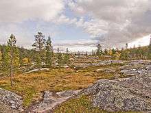 Øvre Dividal national park
 Blåtindan mountain
Climate
Målselv is fairly sheltered from the coastal weather, and has a somewhat inland climate. Mean annual precipitation is 745 millimetres (29.3 in) at Moen, 652 millimetres (25.7 in) at Bardufoss and only 282 millimetres (11.1 in) in the Divi valley, which sits at 282 m (925 ft) above sea level. April through June is the driest period.[5]
There is on average 93 days each winter with daily low -10C or colder, and 28 days with low -20C or colder. The winter season sees on average 68 days with at least 50 cm snow cover on the ground, 126 days with at least 25 cm snow cover, and 179 days with at least 5 cm snow cover. In the warm season there is on average 116 days/ year when the daily average high reaches 10C or warmer and 22 days with daily average high above 20C. Precipitation is fairly moderate, there is on average 75 days/year with at least 3 mm precipitation and 15 days/year with at least 10 mm precipitation. This is based on data from Met.no with 1971-2000 as base period.[6]
| Climate data for Bardufoss (76 m) | |||||||||||||
|---|---|---|---|---|---|---|---|---|---|---|---|---|---|
| Month | Jan | Feb | Mar | Apr | May | Jun | Jul | Aug | Sep | Oct | Nov | Dec | Year |
| Average high °C (°F) | −5.9 (21.4) |
−4.5 (23.9) |
−0.4 (31.3) |
3.8 (38.8) |
9.3 (48.7) |
14.8 (58.6) |
17.4 (63.3) |
15.8 (60.4) |
10.5 (50.9) |
4.3 (39.7) |
−1.7 (28.9) |
−4.7 (23.5) |
4.9 (40.8) |
| Daily mean °C (°F) | −10.4 (13.3) |
−8.9 (16) |
−5.4 (22.3) |
−0.2 (31.6) |
5.6 (42.1) |
10.5 (50.9) |
13.0 (55.4) |
11.5 (52.7) |
6.3 (43.3) |
0.9 (33.6) |
−5.5 (22.1) |
−8.9 (16) |
0.7 (33.3) |
| Average low °C (°F) | −15.1 (4.8) |
−13.7 (7.3) |
−10.9 (12.4) |
−5.1 (22.8) |
1.1 (34) |
6.2 (43.2) |
8.8 (47.8) |
6.9 (44.4) |
2.5 (36.5) |
−2.5 (27.5) |
−9.4 (15.1) |
−13.6 (7.5) |
−3.7 (25.3) |
| Average precipitation mm (inches) | 66 (2.6) |
58 (2.28) |
40 (1.57) |
33 (1.3) |
24 (0.94) |
38 (1.5) |
57 (2.24) |
63 (2.48) |
64 (2.52) |
77 (3.03) |
64 (2.52) |
68 (2.68) |
652 (25.67) |
| Average precipitation days (≥ 1 mm) | 11.2 | 11.4 | 9.3 | 7.8 | 6.8 | 8.9 | 11.7 | 12.7 | 12.9 | 13.7 | 12.0 | 12.5 | 130.9 |
| Source: Norwegian Meteorological Institute[7] | |||||||||||||
Government
All municipalities in Norway, including Målselv, are responsible for primary education (through 10th grade), outpatient health services, senior citizen services, unemployment and other social services, zoning, economic development, and municipal roads. The municipality is governed by a municipal council of elected representatives, which in turn elect a mayor.
Municipal council
The municipal council (Kommunestyre) of Målselv is made up of 25 representatives that are elected to every four years. Currently, the party breakdown is as follows:[8]
| Party Name | Name in Norwegian | Number of representatives | |
|---|---|---|---|
| Labour Party | Arbeiderpartiet | 11 | |
| Progress Party | Fremskrittspartiet | 2 | |
| Conservative Party | Høyre | 4 | |
| Centre Party | Senterpartiet | 4 | |
| Socialist Left Party | Sosialistisk Venstreparti | 1 | |
| Liberal Party | Venstre | 3 | |
| Total number of members: | 25 | ||
Economy
A local newspaper, Nye Troms, covering Målselv, Bardu, and Balsfjord, has its main office in the Olsborg/Moen area. The municipality administration is located at Moen, about 2 kilometres (1.2 mi) east of Olsborg.
Further south along European route E6 is the Bardufoss region, which encompasses the local communities Andselv, Andslimoen, and Heggelia, the latter including the Norwegian army's 6th division. Near Andselv is the Bardufoss Airport and the Bardufoss Air Station of the Royal Norwegian Air Force, including the 337th and 339th Air Force helicopter squadrons. Målselv municipality, together with neighbouring Bardu, has the largest concentration of army bases in the country.
Moving further up the valley, another local community is Rundhaug, and moving eastwards, closer to Øvre Dividal National Park, is the community of Øverbygd, housing two more sub-communities Skjold and Holt. The former also houses the Skjold base for mechanized infantry and combat engineers.
Tourism is a growing industry in Målselv, with the opening of Målselv Fjellandsby, an alpine ski destination. Målselv is also home to Målselvfossen, Norway's national waterfall and a mecca for salmon fishermen. Bardufoss concentration camp was located here during World War II.
References
- ↑ "Navn på steder og personer: Innbyggjarnamn" (in Norwegian). Språkrådet. Retrieved 2015-12-01.
- ↑ Jukvam, Dag (1999). "Historisk oversikt over endringer i kommune- og fylkesinndelingen" (PDF) (in Norwegian). Statistisk sentralbyrå.
- ↑ Rygh, Oluf (1911). Norske gaardnavne: Troms amt (in Norwegian) (17 ed.). Kristiania, Norge: W. C. Fabritius & sønners bogtrikkeri. p. 103.
- ↑ Norske Kommunevåpen (1990). "Nye kommunevåbener i Norden". Retrieved 2008-12-07.
- ↑ "Climate statistics Målselv" (in Norwegian). met.no.
- ↑ "Vanlig Vær Bardufoss" (in Norwegian). met.no. Retrieved 30 December 2013.
- ↑ "eKlima Web Portal". Norwegian Meteorological Institute.
- ↑ "Table: 04813: Members of the local councils, by party/electoral list at the Municipal Council election (M)" (in Norwegian). Statistics Norway. 2015.
External links
 Media related to Målselv at Wikimedia Commons
 The dictionary definition of målselv at Wiktionary
 Troms travel guide from Wikivoyage
- Municipal fact sheet from Statistics Norway
- Picture and information regarding Bardufoss Airport from Avinor